The 12Z WRFGFS and NAM performed well as they forecast precipitation in far SE Arizona. Also, they were both able to predict the morning clouds. As is typical, the model clouds were not as extensive as observed.
 |
| 12Z WRFGFS |
Initializations
There is a cyclonic circulation over eastern Pima county this morning with clouds and some showers in the vicinity. The 700mb chart also shows this feature. All three of the 12Z runs initialized this circulation and much to my surprise, all three have widespread clouds and showers. The WRFRR run has too many showers and storms during the first couple of hours but they did decrease during the morning so it may also be of use today.
The 12Z NAM and GFS have initialized IPW much more accurately in NW Mexico while the RR is still struggling with a wet bias there. Not as bad as previous days though. Overall, in spite of the complex situation, the NAM and GFS have initialized well.
Day 1, July 17
The question for the day is how much heating southern Arizona can get. Even a little may be enough due to the presence of the inverted trough and deep convection is already breaking out in the clear areas over western Pima county. Current cloud trends do show a general decrease in clouds. The temperature forecasts as of 18Z are quite accurate so the models do have a good handle on that so far.
The 12Z WRFNAM has clouds very similar to observed at 18Z while the WRFGFS clouds have thinned too rapidly.
 |
| WRFNAM |
IPW forecasts by all three model runs are accurate as of 16Z. Moisture has slowly increasing as a full gulf surge is underway (as forecast yesterday) and much of Arizona is in the 40mm range by afternoon.
PBL moisture is decent with 10C or wetter air over much of southern Arizona.
Southeasterly mid level wind have increased over southern Arizona as the high center has moved into NM while the IT moves slowly WNW to a position over western Pima this afternoon. Thus steering flow is now sufficient to move storms off of higher terrain.
The CAPE forecast vary quite a bit as the WRFGFS has moderate to high CAPE over SW Arizona. The WRFRR has much less while the WRFNAM is in the middle of the road and has enough CAPE to support deep convection mainly in far southern Arizona. As deep convection is already forming in western Pima, perhaps the WRFGFS is closest to reality.
The afternoon Tucson Skew-t forecast has most of what is needed for storms, except CAPE. PBL is mixed deeply, low level NW winds, mid level SE winds, and SW winds aloft to blow anvils away from storm motion. A cooler PBL plus around -5C at 500mb results in only a couple of hundred J/Kg CAPE.
There is a large difference between the WRFGFS and the other two as the WRFGFS fires off strong/severe storms during the afternoon across central Pima into southern Maricopa. The other two have little or nothing! As activity has already started in that area, perhaps the WRFGFS will be more accurate this afternoon.
 |
| WRFGFS |
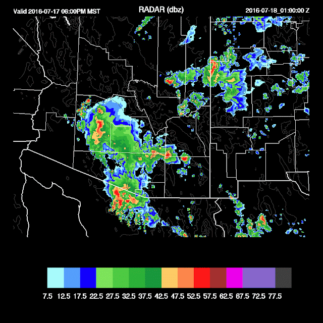
Strong to severe storms continue and move NW across Maricopa county by late in the afternoon. The WRFNAM has a few storms in Pima county at this time while the WRFRR has nothing. So take your pick!
 |
| WRFGFS |
 |
| WRFNAM |
As in Tucson, the late afternoon Phoenix vertical profile has excellent winds and a deeply mixed PBL, but lacks CAPE, but has a bit more than Tucson. Typically it takes outflow intersection for deep convection, but a single strong outflow may be enough. With the moderate inverted V profiles, strong outflows are expected with stronger storms.
The WRFGFS does develop a few storms west of Phoenix with the passage of the outflow boundary and these showers and storms continue into the evening around the Phoenix area.
The WRFNAM develops a few areas of deep convection around Phoenix by 8-9pm but much less than the WRFGFS. My guess is that there will be more than the WRFNAM and less than the WRFGFS. Also, maybe not as early in the evening as the WRFGFS.
Both runs have some activity late across far SE Arizona.
 |
| WRFGFS |
Day 2, July 18
Confidence is automatically low due to the complex and uncertain forecast for Day 1. Debris clouds may again be an issue tomorrow as both model runs have some present, especially over central/western AZ.
The surge weakens somewhat but southerly flow continues to advect in moderate amounts of moisture.
Forecast max CAPE is sufficient to support deep convection over the eastern 1/2 of the state.
Steering flow is very good across eastern Arizona as the high center continues to move towards the central plains.
Deep convection is slow to develop and by late afternoon, scattered strong storms are present over much of eastern Arizona.
The WRFGFS does develop very strong/severe storms over eastern Pima during the evening.


No comments:
Post a Comment
Note: Only a member of this blog may post a comment.