My days of hyping yesterday's event worked out as is was one of the most active days in Arizona in a long time. What was remarkable was the run to run consistency as shown by the Phoenix area temperature plot. This event was actually predicted days in advance and I didn't mention it much until it got within 48 hours to be conservative. The only issue was that WRF is typically unable to forecast the large temperature drops in active situations.

The strong to severe wind forecast verified well too as there were many severe wind reports and many power outages. The call for very strong winds in SW Arizona also verified as there was a gust to 89mph at Gila Bend.
I was really sweating the situation around Phoenix by late afternoon as the IPW crashed to 30mm. The various runs kept it much higher, in the upper 30mm range thus I was quite concerned that deep convection was going to be isolated or maybe nonexistent. The 0Z sounding at Phoenix had only around 300 J/Kg! In spite of that, moisture and surface convergence kicked in and severe storms formed mainly over the southwestern part of the city. As IPW was much lower than predicted, the precipitation forecasts were too high.

Initializations
Widespread activity over much of the state has left behind rain cooled air and out west, clouds. Both Tucson and Phoenix model 2m temperatures are too warm, except for the first 12Z run, the WRFRR. However, the temperatures errors aren't that large so perhaps those errors won't have a large effect. The Phoenix sounding has the 'green onion' shape meaning there is rain cooled air present near the surface.
The eastern 1/2 of the state is mainly clear so some recovery is possible here. Active convection is still underway south of Yuma which is generating widespread clouds over most of southwestern Arizona. Only the NAM was able to initialize clouds well. The RR was especially bad as it has widespread clouds across southern Arizona. The 6Z WRFNAM also looked pretty good so it might be of use today too. A large inverted trough is located over the central GofC with ongoing clouds and storms. It's almost looking like a tropical system. The models seem to of initialized it a bit too far to the south and the Guaymas sounding is missing and could have been of some help better defining the location. Other than that, no obvious cyclonic circulations. Of note on the 300mb plot at 12Z is the area of divergence and difluence over eastern Arizona.
The RR and NAM are a little too wet throughout northern Mexico. Probably not enough to be corrected out. As the morning situation is quite complex, model confidence is only medium today with the WRFNAM and WRFGFS being the favorites.
Day 1
Moisture has increased somewhat over the state due to the ongoing surge. It's a bit hard to tell exactly what the status of the surge is as SW Arizona has ongoing activity and Puerto Penasco and Yuma IPW data is missing. By afternoon, a moderate to strong surge continues to import moisture into Arizona with moderate to high IPW over much of the state.

The model runs have moderate to high CAPE over much of the state except for far eastern Arizona and around Phoenix. Deep convection will likely initiate early over high terrain and be very strong.

Tucson's 12Z sounding was only slightly modified by previous activity and by late afternoon, the forecast skew-t indicates a high amount of CAPE, deeply mixed PBL, and very favorable winds. Based just on this, I'd say a very active day in the Tucson area. Both the WRFGFS and NAM are very similar. The odd man out is the WRFRR as it has limited CAPE as it did not warm nearly as much. (clouds?)

The situation looks very much like yesterday, as by late afternoon, organized convection is moving off the high terrain towards the lower deserts of Maricopa/Pinal/Pima. The WRFGFS is especially active and I'll go with the middle of the road WRFNAM. The WRFRR is nearly devoid of deep convection over southern Arizona.
 |
| WRFNAM |
Thunderstorm outflows again converge over the deserts, driving additional convection. Outflow wind speeds are still strong, but nowhere like what was seen yesterday.

The WRFGFS is much more active with severe storms around Tucson.

The WRF does forecast upper divergence for much of eastern Arizona and that could be partially responsible for the active WRFGFS.

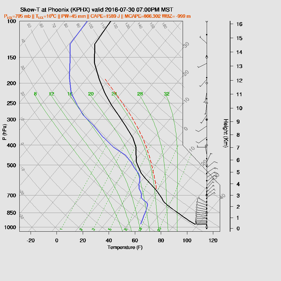
The Phoenix evening skew-t forecast is capped with a shallow mixed layer. Mid-level wind speeds are also weak. CAPE is quite high, but in spite of that, not much activity is expected unless strong outflows intersect to provide the mesoscale needed to lift to the LFC.

It's a different story in the WRFGFS as there is less of an inversion, a wetter airmass, and better NE steering. (and slight upper divergence?)
Outflows intersect over Pinal and Maricopa counties around 8-9pm and fire off deep convection. I think this solution is less likely than the WRFNAM. However, if SE Arizona convection is strong and outflow make their way towards Phoenix, the below could happen.

I'm not bothering with a Day 2 forecast in this complex and uncertain environment.
No comments:
Post a Comment
Note: Only a member of this blog may post a comment.