Previous Day
Eventually, a broken clock is right. Quite a bit of activity formed in and around the Tucson area around sunset producing 1/3 of an inch or more over much of the eastern 1/2 of town and all but one of the 0-6-12Z suite predicted activity. The odd man out was the 15Z WRFRR.

Initializations
Clouds and a few showers were present over far southern Arizona this morning. No inverted troughs or MCVs were seen in either the satellite imagery or the upper air maps. The 300-250mb high is right on top of southern Arizona with an area of divergence. Perhaps that was the cause? I was happy to see that both the NAM and the GFS were able to initialize the clouds fairly well and the WRFGFS even had a few showers during the first few hours of the run.
The RR and GFS had minimal IPW errors while the NAM was somewhat too wet in NW Mexico.
The only issue I can see is the model runs are a bit too warm around the Tucson area as the cooling from the recent precipitation was not initialized too well. However, over the past few hours, observed temperatures are catching up with the model forecasts. Overall, the synoptic/mesoscale situation is straightfoward and the model initializations look good and forecast confidence is high especially as Guaymas is missing this morning.
Day 1, July 27
Finally, steering flow becomes optimal for moving storms from the high terrain into the lower deserts. The high center consolidates over southern Nevada and northeasterly steering flow increases to 10-20 knots over the state.
 Weak southerly flow from the GofC into southern Arizona continues with SE Arizona being especially wet with IPW in the upper 30mm range. As previously forecast, dry air has moved into NE Arizona and surface winds have set up a convergence zone aong the edge of the Rim and White Mountains.

OK, 2 out of three ingredients are there. What about CAPE? It looks like we are 3 for 3 as CAPE is moderate to high south of the Rim into SE Arizona. With maximum heating being realized, it does appear that SE Arizona is primed for a classic 'Rim shot'/Tropical Squall line event.

The WRFNAM forms deep convection over the high terrain of western NM and eastern Arizona during the afternoon and moves rapidly (for Arizona) to the southwest towards Pinal, Pima, and Cochise counties.

These storms produce strong outflows which provide the lift needed for new storms to form ahead of the previous line. Also, low level inflow, while not perpindicular, is still favorable as wind speeds are in the 10-14 knot range from the NW.

The Tucson afternoon vertical profile forecast indicates a deep mixed layer/inverted V, NW winds in the PBL with what looks like a moist 11 g/kg mixing ratio and 10 to 15 knots of NE steering flow. Textbook case for a tropical squall line.

Now comes the bad news. The model runs have widely varying solutions for where the storms develop and move. The WRFRR has very few storms in SE Arizona, which I seriously doubt (but it has been correct recently). The WRFGFS is in the middle and has deep convection and strong outflows mainly into Cochise county.
 The WRFNAM has strong storms in eastern Pima and western Cochise during the early evening.
 The WRFGFS does start to develop isolated deep convection later in the evening from Maricopa county down to eastern Pima county so perhaps if Tucson doesn't get activity earlier, they will later.

It's not clear what will happen in the Phoenix area tonight. (Is it ever?) Both model runs do forecast over 1000 J/Kg of CAPE, enough to support deep convection and favorible shear and steering flow. The unknown is if outflows will come into the area and trigger deep convection and as the WRFGFS shows, some storms do develop later in the evening. The mixed layer is very high thus storms that do form will produce very strong/severe winds.

As the 6Z runs can be accurate, I looked to see what they had to say and they were much more active across the Phoenix area and down into Tucson.

Day 2, July 28
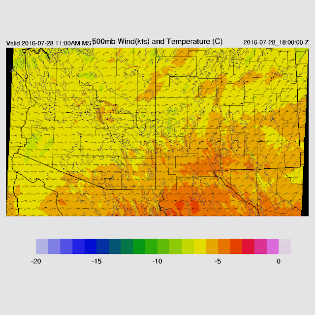
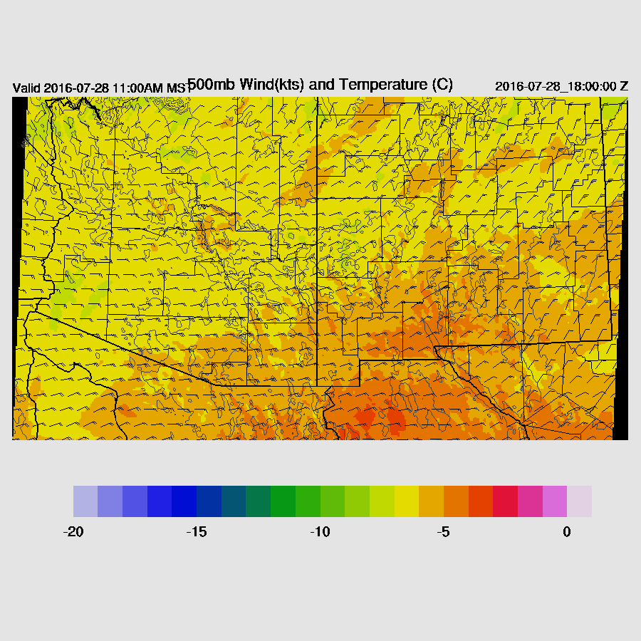
Very good ENE steering flow continues over the state and maybe too much of a good thing over far southern Arizona where speeds approach 30 knots. The WRFNAM also lowers 500 mb temperatures by a degree or two.
A weak and shallow surge continues, but moisture decreases as the drier air to the NE and E starts to work into the southern 1/2 of Arizona. Still, sufficient for storm formation.

CAPE is moderate over much of SE and central Arizona. The WRFNAM is a bit cooler aloft thus it has more CAPE than the WRFGFS.
Less activity is forecast for the Pima/Pinal/Maricopa area, but some storms do make their way into the lower deserts during the late afternoon and into the evening.
Eventually, a broken clock is right. Quite a bit of activity formed in and around the Tucson area around sunset producing 1/3 of an inch or more over much of the eastern 1/2 of town and all but one of the 0-6-12Z suite predicted activity. The odd man out was the 15Z WRFRR.

 |
| 12Z WRFNAM |
Initializations
Clouds and a few showers were present over far southern Arizona this morning. No inverted troughs or MCVs were seen in either the satellite imagery or the upper air maps. The 300-250mb high is right on top of southern Arizona with an area of divergence. Perhaps that was the cause? I was happy to see that both the NAM and the GFS were able to initialize the clouds fairly well and the WRFGFS even had a few showers during the first few hours of the run.
The RR and GFS had minimal IPW errors while the NAM was somewhat too wet in NW Mexico.
The only issue I can see is the model runs are a bit too warm around the Tucson area as the cooling from the recent precipitation was not initialized too well. However, over the past few hours, observed temperatures are catching up with the model forecasts. Overall, the synoptic/mesoscale situation is straightfoward and the model initializations look good and forecast confidence is high especially as Guaymas is missing this morning.
Day 1, July 27
Finally, steering flow becomes optimal for moving storms from the high terrain into the lower deserts. The high center consolidates over southern Nevada and northeasterly steering flow increases to 10-20 knots over the state.


OK, 2 out of three ingredients are there. What about CAPE? It looks like we are 3 for 3 as CAPE is moderate to high south of the Rim into SE Arizona. With maximum heating being realized, it does appear that SE Arizona is primed for a classic 'Rim shot'/Tropical Squall line event.

The WRFNAM forms deep convection over the high terrain of western NM and eastern Arizona during the afternoon and moves rapidly (for Arizona) to the southwest towards Pinal, Pima, and Cochise counties.

These storms produce strong outflows which provide the lift needed for new storms to form ahead of the previous line. Also, low level inflow, while not perpindicular, is still favorable as wind speeds are in the 10-14 knot range from the NW.

The Tucson afternoon vertical profile forecast indicates a deep mixed layer/inverted V, NW winds in the PBL with what looks like a moist 11 g/kg mixing ratio and 10 to 15 knots of NE steering flow. Textbook case for a tropical squall line.

Now comes the bad news. The model runs have widely varying solutions for where the storms develop and move. The WRFRR has very few storms in SE Arizona, which I seriously doubt (but it has been correct recently). The WRFGFS is in the middle and has deep convection and strong outflows mainly into Cochise county.


It's not clear what will happen in the Phoenix area tonight. (Is it ever?) Both model runs do forecast over 1000 J/Kg of CAPE, enough to support deep convection and favorible shear and steering flow. The unknown is if outflows will come into the area and trigger deep convection and as the WRFGFS shows, some storms do develop later in the evening. The mixed layer is very high thus storms that do form will produce very strong/severe winds.

As the 6Z runs can be accurate, I looked to see what they had to say and they were much more active across the Phoenix area and down into Tucson.

Day 2, July 28
Very good ENE steering flow continues over the state and maybe too much of a good thing over far southern Arizona where speeds approach 30 knots. The WRFNAM also lowers 500 mb temperatures by a degree or two.
A weak and shallow surge continues, but moisture decreases as the drier air to the NE and E starts to work into the southern 1/2 of Arizona. Still, sufficient for storm formation.

CAPE is moderate over much of SE and central Arizona. The WRFNAM is a bit cooler aloft thus it has more CAPE than the WRFGFS.
 |
| WRFNAM |
Less activity is forecast for the Pima/Pinal/Maricopa area, but some storms do make their way into the lower deserts during the late afternoon and into the evening.
 |
| WRFNAM |
No comments:
Post a Comment
Note: Only a member of this blog may post a comment.