Previous Day, July 17
The widespread morning and midday clouds and showers kept heating to a minimum across the lower deserts with only a few areas of activity during the afternoon and evening. The WRFGFS was a complete failure and the WRFNAM was pretty good with only slightly too much activity. Both WRFRR runs did not have enough activity. The WRFGFS did do a better job during the evening in far SE Arizona where a small MCS formed. I got 1.05" at my place in Paradise AZ.


Initializations
Morning clouds are mainly present over north central Arizona, associated with the leftover MCV and other areas are clearing rapidly. The NAM cloud initialization was poor as it hardly had any clouds. This might not be too big of a deal as much of the southern 1/2 of AZ is mostly clear. The RR had too many clouds across southern Arizona while the GFS was the most accurate. The model runs are doing fairly well with surface heating and only slightly too cool around the Tucson area.
Other than the central Arizona MCV, no other mid level circulations were noted. There is a large upper inverted trough making it's way to the NW over north central Mexico. This may play a factor later today for southern Arizona as upper flow becomes divergent. All three of the 12Z initializations are missing the Arizona MCV, but that isn't a problem as it's moving away.
The NAM and GFS IPW were initialized well while the RR has a moderate wet bias over far southern Arizona into Mexico. Just based on the initializations, I'd say the GFS is best, followed by the NAM. However, the WRFGFS has been struggling lately with too much activity.
Day 1, July 18
Weak southerly flow continues to advect moisture into the state with just about all areas seeing moderate to high IPW. The Phoenix area is in the upper 40mm range by afternoon.

CAPE is forecast to be moderate over much of the eastern 1/2 of the state with high amounts in SE Arizona thus I'd expect that area to be the most active.

As the upper IT moves slowly to the NW, the eastern 1/3 of the state is under difluence aloft with some divergence seen. This area was partially responsible for the far SE Arizona activity overnight.

The vertical wind profile has a good low level shear and decent mid level steering. Upper winds may blow anvils out in front of storms cutting off heating, though. As upper winds are only 15 knots, perhaps this won't be an issue. Decent moisture and CAPE during the afternoon in and around Tucson may support some deep convection in the area.

The WRFGFS and WRFNAM develop deep convection over the high terrain of SE Arizona and along the Rim/White Mountains during the afternoon. The runs disagree where the most intense and organized storms will be as the WRFNAM has them around the Flagstaff area by late afternoon while the WRFGFS has areas of strong storms across SE Arizona. It looks like storms threaten Tucson during the late afternoon with maybe a few in the valley. Most will remain over the higher terrain.
By evening, both model runs have scattered activity over eastern Arizona into parts of south central Arizona.

The WRFGFS has a moderate amount of CAPE and a deeply mixed PBL at Phoenix during the evening thus deep convection is possible. Mid level winds are weak thus organization may be an issue. The WRFNAM has much less CAPE.

Both model runs do have some shower and storm activity around Phoenix during the evening with the WRFGFS producing some strong storms.
Day 2, July 18
The 500mb high center has moved off into the Great Plains which puts most of Arizona in moderate SE flow. A weak IT is located over southwestern Arizona. I don't know where this feature came from as it seems to of just materialized out of thin air over the past 18 hours. Maybe it's a reflection of the upper IT which is stalled just south of El Paso which continues the weak upper difluence over eastern Arizona.


Moisture remains mostly the same except for far eastern Arizona where slightly drier air has started to work it's way in on southeasterly flow.

CAPE is again sufficient to support deep convection for the eastern 1/3 of the state. It looks like areas west of a Tucson-Flagstaff line will not see much.

There is enough CAPE for Tucson to see some activity during the late afternoon/early evening. Steering winds are favorable for moving storms off of the nearby mountains.

Both models do have a fair coverage of storms over SE Arizona during the late afternoon into the evening with a good chance for Tucson to see some activity.

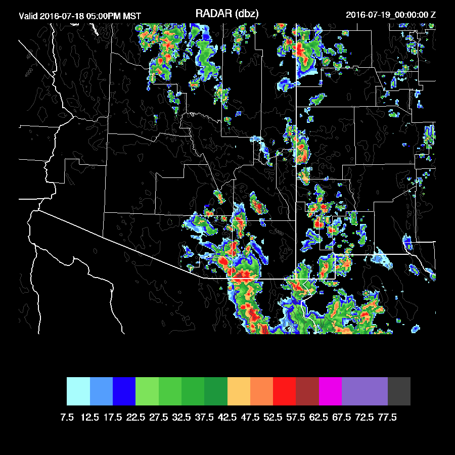
The widespread morning and midday clouds and showers kept heating to a minimum across the lower deserts with only a few areas of activity during the afternoon and evening. The WRFGFS was a complete failure and the WRFNAM was pretty good with only slightly too much activity. Both WRFRR runs did not have enough activity. The WRFGFS did do a better job during the evening in far SE Arizona where a small MCS formed. I got 1.05" at my place in Paradise AZ.


Initializations
Morning clouds are mainly present over north central Arizona, associated with the leftover MCV and other areas are clearing rapidly. The NAM cloud initialization was poor as it hardly had any clouds. This might not be too big of a deal as much of the southern 1/2 of AZ is mostly clear. The RR had too many clouds across southern Arizona while the GFS was the most accurate. The model runs are doing fairly well with surface heating and only slightly too cool around the Tucson area.
Other than the central Arizona MCV, no other mid level circulations were noted. There is a large upper inverted trough making it's way to the NW over north central Mexico. This may play a factor later today for southern Arizona as upper flow becomes divergent. All three of the 12Z initializations are missing the Arizona MCV, but that isn't a problem as it's moving away.
The NAM and GFS IPW were initialized well while the RR has a moderate wet bias over far southern Arizona into Mexico. Just based on the initializations, I'd say the GFS is best, followed by the NAM. However, the WRFGFS has been struggling lately with too much activity.
Day 1, July 18
Weak southerly flow continues to advect moisture into the state with just about all areas seeing moderate to high IPW. The Phoenix area is in the upper 40mm range by afternoon.

CAPE is forecast to be moderate over much of the eastern 1/2 of the state with high amounts in SE Arizona thus I'd expect that area to be the most active.

As the upper IT moves slowly to the NW, the eastern 1/3 of the state is under difluence aloft with some divergence seen. This area was partially responsible for the far SE Arizona activity overnight.

The vertical wind profile has a good low level shear and decent mid level steering. Upper winds may blow anvils out in front of storms cutting off heating, though. As upper winds are only 15 knots, perhaps this won't be an issue. Decent moisture and CAPE during the afternoon in and around Tucson may support some deep convection in the area.

The WRFGFS and WRFNAM develop deep convection over the high terrain of SE Arizona and along the Rim/White Mountains during the afternoon. The runs disagree where the most intense and organized storms will be as the WRFNAM has them around the Flagstaff area by late afternoon while the WRFGFS has areas of strong storms across SE Arizona. It looks like storms threaten Tucson during the late afternoon with maybe a few in the valley. Most will remain over the higher terrain.
 |
| WRFNAM |
 |
| WRFGFS |
By evening, both model runs have scattered activity over eastern Arizona into parts of south central Arizona.

The WRFGFS has a moderate amount of CAPE and a deeply mixed PBL at Phoenix during the evening thus deep convection is possible. Mid level winds are weak thus organization may be an issue. The WRFNAM has much less CAPE.

Both model runs do have some shower and storm activity around Phoenix during the evening with the WRFGFS producing some strong storms.
 |
| WRFGFS |
The 500mb high center has moved off into the Great Plains which puts most of Arizona in moderate SE flow. A weak IT is located over southwestern Arizona. I don't know where this feature came from as it seems to of just materialized out of thin air over the past 18 hours. Maybe it's a reflection of the upper IT which is stalled just south of El Paso which continues the weak upper difluence over eastern Arizona.


Moisture remains mostly the same except for far eastern Arizona where slightly drier air has started to work it's way in on southeasterly flow.

CAPE is again sufficient to support deep convection for the eastern 1/3 of the state. It looks like areas west of a Tucson-Flagstaff line will not see much.

There is enough CAPE for Tucson to see some activity during the late afternoon/early evening. Steering winds are favorable for moving storms off of the nearby mountains.

Both models do have a fair coverage of storms over SE Arizona during the late afternoon into the evening with a good chance for Tucson to see some activity.

No comments:
Post a Comment
Note: Only a member of this blog may post a comment.