The model runs had a fairly good handle on the situation yesterday except for along the border where they were all too early with the deep convection that occurred there. It was the right idea, just 6 hours or so too early!
Initializations
The large northern Sonora MCS continues to dissipate and has caused a very strong outflow to occur over much of southern Arizona. My worry is that the initializations will have a tough time with the cooling that has occurred. The temperature forecasts are running a few degrees above observed so the models are struggling a bit and they may develop deep convection a little too early.

It's difficult to pick out any cyclonic circulations around the SW. The upper air data does show a weak IT located just south of NM while the WV imagery shows another off the northern Baja coast. A MCV is certainly present with the decaying MCS over Sonora and is still obscured by cirrus. All initializations have the two upper inverted troughs while only the RR have the MCS/MCV initialized correctly. The RR outflow into SW Arizona is too strong. Clouds are not an issue today as it is mainly clear across the state.
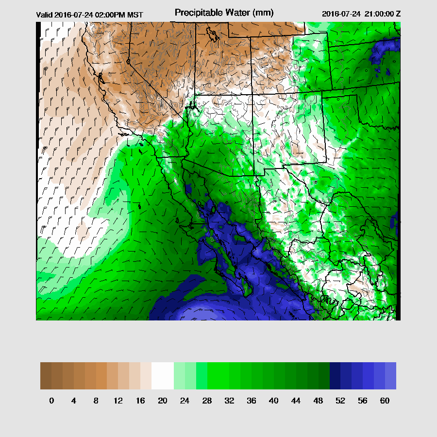
All initializations are struggling around Hermosillo where they are all 3-5mm too wet. Other than that, IPW errors are minimal. Overall, model initializations are good with no clear favorites except to say the the WRFGFS and the WRFNAM to some extent, have had too many storms the last few days. I'm leaning towards the RR runs because of that.
Day 1
A strong outflow surge is underway with strong winds and high dew-points over SW Arizona. In spite of that, the IPW is only around 40mm there thus it's not looking like a deep full gulf surge and more like a strong outflow surge. Other parts of the state have also had increasing moisture as Tucson is up to 40mm. The various runs all have different solutions regarding the surge. The WRFGFS has a full gulf surge underway with SSE winds all the way up the GofC.
 |
| WRFGFS |
The WRFRR 15Z dev version is at the other extreme as it has mainly light and variable winds and has less moisture over the northern end of the GofC. I took a quick look at surface winds using WunderMap and most stations were reporting light southerly winds. My guess is that the WRFRR is correct saying the full gulf surge is weak or even is absent.
 |
| WRFRR |
Even without the support of a full surge, plenty of moisture exists over the state with the classic clockwise curl of the winds and moist PBL associated with a surge event.

All models agree that SE Arizona will have moderate to high CAPE which will support very strong deep convection at some point.

As Bob Maddox mentioned in his discussion, there is a capping inversion present on the 12Z Tucson sounding. Strong outflows or intersecting outflows are going to be needed to trigger deep convection in the lower elevations. Shear profile is good and by afternoon, 15 knots of SE steering is present and is better than it has been. Plus, upper flow is light westerly thus steering anvils away from the storm motion.

Deep convection is slow to develop, but once it gets going, the resulting storms are very strong. Despite their differences, all model runs point to SE Arizona and eastern Arizona as the most active areas late this afternoon.

All runs continue strong/severe storms around SE Arizona into the evening with maybe another MCS forming along the border.
 |
| WRFRR dev |
 |
| WRFNAM |
There is potential for deep convection around the Phoenix area as CAPE is forecast to be at least 1000 J/Kg with some model run as high as 1800. Steering flow is weak and Phoenix will need a strong or intersecting outflows to develop widespread deep convection.

Only the WRFGFS sends moderate outflows into the Phoenix.

It does manage to develops some storms during the late evening in the Phoenix area. However, it's the only run with activity thus the probability is low.

Day 2 will follow later
No comments:
Post a Comment
Note: Only a member of this blog may post a comment.