Previous Day
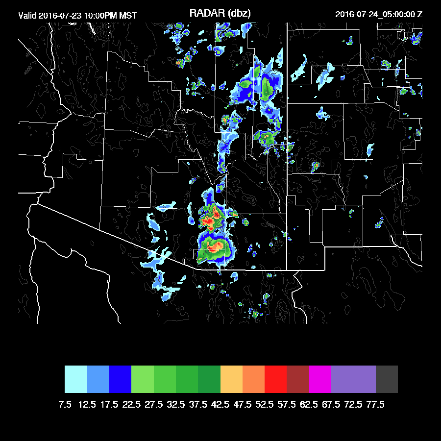
Overall, less activity than the previous day, but again, some isolated areas had very heavy rain.

The WRFNAM and especially the WRFGFS had too much activity. As Bob Maddox also noticed, the WRFGFS has been this way recently. It has also had too much activity for longer term forecasts too. The word must have gotten out about my RR complaints as the 15Z WRFRR dev version was the best. It still missed the isolated heavy precipitation. That's what I get for badmouthing the RR. None of the models picked up on the late night/early morning storms across Pima county.
Initializations
As mentioned above, areas of showers and storms have been moving westward over Pima county this morning. RADAR shows a distinct cyclonic motion associated with the area but I don't see any evidence in the upper air maps. My guess is the Mexican upper IT, now located over far northern Chihuahua was responsible for this activity. Note that Guaymas seems to be reporting regularly at 12Z now and I hope I don't jinx it by saying that! The high center is quite diffuse and is located on an axis from around Flagstaff over to Oklahoma. OKC is reporting a -3C@500mb! Warm air is upstream from us too with temperatures around -4 to -6C and Tucson's 500mb height is 5970m. What a ridge! As mentioned, the upper trough is moving towards SE Arizona and seem initialized well.
Only the RR initialized the clouds over Pima county. However, clouds and showers are dissipating fast and moving west so there should be no issues with that error. Other than that, it's clear in the model initializations and in real life.
The RR and GFS have mainly small errors in their IPW initializations while the NAM is somewhat too wet in northern Mexico and small enough that the correction routine should take care of it. Overall, all the model initializations look good and there is no clear favorite except to be cautious of the WRFGFS because of it's high activity bias recently.
Day 1, July 22
Previous runs have been decreasing moisture for today and that appears to be the case, at least for eastern Arizona. Also, it has been relatively dry across western Arizona and NW Mexico too and that continues with IPW of only 38mm at Hermosillo and down to 25mm at Puerto Penasco recently. However, PP is now trending up and is back to 40mm.

Moderate amounts of moisture continue to be present over much of the state except for SE Arizona where dry air advection from the east is occurring.

Once again, mid-level steering flow is very light from the east while temperatures are not all that good either with -4 to -6C over the area. Much of eastern Arizona does have relatively cool air at 500mb.

I was somewhat surprised to see that much of eastern Arizona had a moderate amount of CAPE in both the WRFRR and WRFNAM while the WRFGFS looked somewhat more realistic as it has somewhat less. Still, sufficient to support some deep convection.
The afternoon vertical profile over Tucson looks unfavorable for deep convection as CAPE is limited and the mixed layer is too shallow to reach the LFC. Mid level winds are also bad and any storms that do form over higher terrain will have their anvils pushed out ahead of them.

Deep convection is limited to the Rim and White mountains this afternoon.
As has been the case recently, the WRFGFS is more active and manages to develop quite a bit of deep convection around Tucson. The WRFNAM does this too, but not as strong or widespread while the RR has very little activity. I'll go with the middle of the road.
What will need to happen for the WRFNAM (or GFS) to verify is to have the IPW increase to around 32mm. Also, the early evening wind profile looks somewhat better with a little low-level shear along with 15 knots of mid-level easterly flow - note the deeply mixed PBL and large inverted V. The WRFRR has so little activity as it keeps the IPW around 28mm.

Storms that do form will produce very strong outflows. The WRFGFS and WRFNAM move outflows from activity to the NE of Tucson into the valley by early evening, strong enough to trigger deep convection. If IPW can come up into the low 30mm range, this could indeed occur.

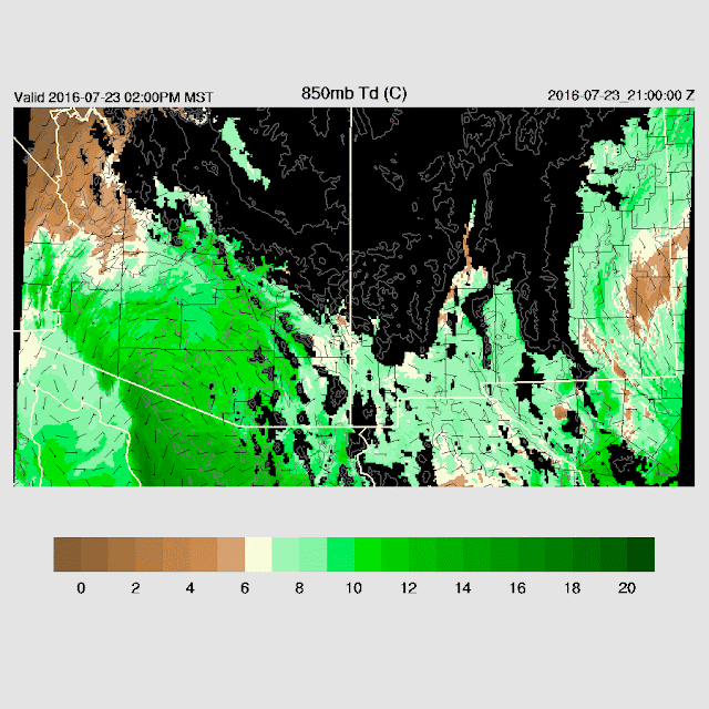
Looking upstream from Tucson, towards Phoenix 850mb dew point temperatures are marginal-around 10C. It's a tough call for Tucson.

Day 2, July 23
The big story for the next few days is going to be TS Frank as it moves slowly to the NW. Will it get close enough to the southern GofC to trigger a big gulf surge? Already, there has been considerable deep convection to the NE of Frank over Mexico thus creating cooler, wetter, and denser air around the southern gulf. The WRFNAM is a bit faster and has Frank just to the SW of Cabo by 18Z tomorrow and triggering a strong surge up the gulf. This is a day or two ahead of previous forecasts. The WRFGFS is a bit slower and weaker with Frank, but still, a weak surge is underway by 18Z.
By 21Z, both models have a big increase in PBL moisture since yesterday plus somewhat stronger low-level flow. It certainly is looking much better for a big outbreak.
 CAPE is somewhat slow to increase but is sufficiently high to support deep convection over much of the eastern 1/2 of the state.
 A high center at 500mb is located somewhere around NE Arizona/NW NM with mainly light flow except for southern Arizona where it's around 10 to 15knots. Better than light and variable.
 The WRFNAM and WRFGFS has an excellent wind profile for southern Arizona during the late afternoon. PBL is mixed deeply along with moderate CAPE. A classic looking skew-t for organized strong/severe storms.

Both runs develop scattered deep convection over the Rim/White Mountains/SE Arizona during the afternoon and by early evening, scattered strong to severe storms are present across far southern Arizona.

Thunderstorm outflows will be strong and likely to move into the Tucson area during the evening and trigger deep convection.

Overall, less activity than the previous day, but again, some isolated areas had very heavy rain.

The WRFNAM and especially the WRFGFS had too much activity. As Bob Maddox also noticed, the WRFGFS has been this way recently. It has also had too much activity for longer term forecasts too. The word must have gotten out about my RR complaints as the 15Z WRFRR dev version was the best. It still missed the isolated heavy precipitation. That's what I get for badmouthing the RR. None of the models picked up on the late night/early morning storms across Pima county.
 | |
| WRFRR dev |
As mentioned above, areas of showers and storms have been moving westward over Pima county this morning. RADAR shows a distinct cyclonic motion associated with the area but I don't see any evidence in the upper air maps. My guess is the Mexican upper IT, now located over far northern Chihuahua was responsible for this activity. Note that Guaymas seems to be reporting regularly at 12Z now and I hope I don't jinx it by saying that! The high center is quite diffuse and is located on an axis from around Flagstaff over to Oklahoma. OKC is reporting a -3C@500mb! Warm air is upstream from us too with temperatures around -4 to -6C and Tucson's 500mb height is 5970m. What a ridge! As mentioned, the upper trough is moving towards SE Arizona and seem initialized well.
Only the RR initialized the clouds over Pima county. However, clouds and showers are dissipating fast and moving west so there should be no issues with that error. Other than that, it's clear in the model initializations and in real life.
The RR and GFS have mainly small errors in their IPW initializations while the NAM is somewhat too wet in northern Mexico and small enough that the correction routine should take care of it. Overall, all the model initializations look good and there is no clear favorite except to be cautious of the WRFGFS because of it's high activity bias recently.
Day 1, July 22
Previous runs have been decreasing moisture for today and that appears to be the case, at least for eastern Arizona. Also, it has been relatively dry across western Arizona and NW Mexico too and that continues with IPW of only 38mm at Hermosillo and down to 25mm at Puerto Penasco recently. However, PP is now trending up and is back to 40mm.

Moderate amounts of moisture continue to be present over much of the state except for SE Arizona where dry air advection from the east is occurring.

Once again, mid-level steering flow is very light from the east while temperatures are not all that good either with -4 to -6C over the area. Much of eastern Arizona does have relatively cool air at 500mb.

I was somewhat surprised to see that much of eastern Arizona had a moderate amount of CAPE in both the WRFRR and WRFNAM while the WRFGFS looked somewhat more realistic as it has somewhat less. Still, sufficient to support some deep convection.
 |
| WRFGFS |
The afternoon vertical profile over Tucson looks unfavorable for deep convection as CAPE is limited and the mixed layer is too shallow to reach the LFC. Mid level winds are also bad and any storms that do form over higher terrain will have their anvils pushed out ahead of them.

Deep convection is limited to the Rim and White mountains this afternoon.
 |
| WRFNAM |
As has been the case recently, the WRFGFS is more active and manages to develop quite a bit of deep convection around Tucson. The WRFNAM does this too, but not as strong or widespread while the RR has very little activity. I'll go with the middle of the road.
 |
| WRFNAM |
What will need to happen for the WRFNAM (or GFS) to verify is to have the IPW increase to around 32mm. Also, the early evening wind profile looks somewhat better with a little low-level shear along with 15 knots of mid-level easterly flow - note the deeply mixed PBL and large inverted V. The WRFRR has so little activity as it keeps the IPW around 28mm.

Storms that do form will produce very strong outflows. The WRFGFS and WRFNAM move outflows from activity to the NE of Tucson into the valley by early evening, strong enough to trigger deep convection. If IPW can come up into the low 30mm range, this could indeed occur.

Looking upstream from Tucson, towards Phoenix 850mb dew point temperatures are marginal-around 10C. It's a tough call for Tucson.

Day 2, July 23
The big story for the next few days is going to be TS Frank as it moves slowly to the NW. Will it get close enough to the southern GofC to trigger a big gulf surge? Already, there has been considerable deep convection to the NE of Frank over Mexico thus creating cooler, wetter, and denser air around the southern gulf. The WRFNAM is a bit faster and has Frank just to the SW of Cabo by 18Z tomorrow and triggering a strong surge up the gulf. This is a day or two ahead of previous forecasts. The WRFGFS is a bit slower and weaker with Frank, but still, a weak surge is underway by 18Z.
 |
| WRFGFS |
By 21Z, both models have a big increase in PBL moisture since yesterday plus somewhat stronger low-level flow. It certainly is looking much better for a big outbreak.


Both runs develop scattered deep convection over the Rim/White Mountains/SE Arizona during the afternoon and by early evening, scattered strong to severe storms are present across far southern Arizona.

Thunderstorm outflows will be strong and likely to move into the Tucson area during the evening and trigger deep convection.
No comments:
Post a Comment
Note: Only a member of this blog may post a comment.