Good news on the Suominet GPSMET IPW front, for once. AZTP, Tempe is now operational and finally fills in a major gap in the coverage in south central Arizona.

The break in the monsoon continues across the state except for occasional activity along the border as the mid level high meanders around southern Arizona into Texas and keeps the monsoon moisture south. Plenty of moisture in Mexico, as seen in the above IPW plot. The strong (for this time of year) 500mb flow continues across the northern 1/2 of the county, causing the ridge suppression. Additionally, the strength and position of the high is not allowing any of the many tropical systems to move close enough to the southern Gulf of California to initiate a gulf surge.

Day 2 (2016-07-16)
Over the next few days, the various model runs are now moving the high center slowly to the northeast thus allowing mid level winds to shift to southeasterly and the higher moisture in NW Mexico to advect into the southern 1/2 of Arizona. Note the cool 500mb temperatures of around -9C over Arizona.

Overnight, what appears to be an outflow surge from thunderstorms in NW Mexico moves into southern Arizona. The WRFGFS and WRFNAM are quite different with the amount of IPW present with the WRFGFS much wetter in SW Arizona. I'll go with the more conservative WRFNAM.

Of course, this has a big impact on the max CAPE forecast and again, I am conservative and lean towards the WRFNAM. Perhaps reality will be somewhere in the middle? In any case, enough CAPE is present in the WRFNAM to support storms over much of SE Arizona tomorrow.
In spite of the moisture differences, the two models are very similar in developing deep convection over the higher terrain of SE Arizona during the late afternoon and early evening.

Later in the evening, the WRFGFS continues with a few storms perhaps even into Pinal county.
As inverted V profiles are large with the mixed layer above 700mb, there are likely to be very strong winds associated with storms and the possibility of large scale outflows and associated dust storm/haboob events.

Thunderstorms are likely to be around Tucson with possibly a few within the city. What appears likely is a big outflow into town during the evening.

Day 3 (2016-07-17)
The tropical system, currently classified as TD Six-E, does come a little farther to the north than previous systems an may be close enough to increase the moisture over the southern Gulf of California and trigger a weak surge up the Gulf. Moisture does increase substantially across the state by Sunday due to a combination of the gulf surge and outflow surges from previous storms.

Max CAPE forecast isn't all that great with only 500-1000 J/Kg. Still, enough to support some deep convection.

What does look good is the wind profile as there is good low level westerly flow, that is relatively moist, plus good mid level SE steering flow and only weak SSW flow aloft to keep anvils interfering with heating.
The model runs have been inconsistent over the past few days regarding the amount of activity for Sunday. Some runs have been very active and some with only a little thus forecast confidence is low. In general, it is also difficult to forecast accurately this far in advance this time of year. Saying that, both the WRFGFS and WRFNAM develop storms over southeastern AZ and up over the White Mountains and Rim by mid afternoon Sunday and are fairly similar thus there is some confidence in the forecast.

SE Arizona storms are then steered into the lower deserts with some strong storms by early evening. Tucson looks likely to see strong storms in and around the valley. At this point, it looks unlikely that Phoenix will see any deep convection activity.

What is possible in/around Phoenix is a big dust storm/haboob event around 8-9pm.


The break in the monsoon continues across the state except for occasional activity along the border as the mid level high meanders around southern Arizona into Texas and keeps the monsoon moisture south. Plenty of moisture in Mexico, as seen in the above IPW plot. The strong (for this time of year) 500mb flow continues across the northern 1/2 of the county, causing the ridge suppression. Additionally, the strength and position of the high is not allowing any of the many tropical systems to move close enough to the southern Gulf of California to initiate a gulf surge.

Day 2 (2016-07-16)
Over the next few days, the various model runs are now moving the high center slowly to the northeast thus allowing mid level winds to shift to southeasterly and the higher moisture in NW Mexico to advect into the southern 1/2 of Arizona. Note the cool 500mb temperatures of around -9C over Arizona.

Overnight, what appears to be an outflow surge from thunderstorms in NW Mexico moves into southern Arizona. The WRFGFS and WRFNAM are quite different with the amount of IPW present with the WRFGFS much wetter in SW Arizona. I'll go with the more conservative WRFNAM.

Of course, this has a big impact on the max CAPE forecast and again, I am conservative and lean towards the WRFNAM. Perhaps reality will be somewhere in the middle? In any case, enough CAPE is present in the WRFNAM to support storms over much of SE Arizona tomorrow.
 |
| 12Z WRFNAM |
In spite of the moisture differences, the two models are very similar in developing deep convection over the higher terrain of SE Arizona during the late afternoon and early evening.

Later in the evening, the WRFGFS continues with a few storms perhaps even into Pinal county.
 |
| 12Z WRFGFS |
As inverted V profiles are large with the mixed layer above 700mb, there are likely to be very strong winds associated with storms and the possibility of large scale outflows and associated dust storm/haboob events.

Thunderstorms are likely to be around Tucson with possibly a few within the city. What appears likely is a big outflow into town during the evening.

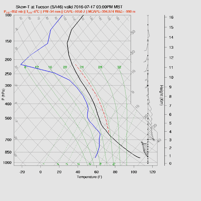
Day 3 (2016-07-17)
The tropical system, currently classified as TD Six-E, does come a little farther to the north than previous systems an may be close enough to increase the moisture over the southern Gulf of California and trigger a weak surge up the Gulf. Moisture does increase substantially across the state by Sunday due to a combination of the gulf surge and outflow surges from previous storms.

Max CAPE forecast isn't all that great with only 500-1000 J/Kg. Still, enough to support some deep convection.

What does look good is the wind profile as there is good low level westerly flow, that is relatively moist, plus good mid level SE steering flow and only weak SSW flow aloft to keep anvils interfering with heating.

The model runs have been inconsistent over the past few days regarding the amount of activity for Sunday. Some runs have been very active and some with only a little thus forecast confidence is low. In general, it is also difficult to forecast accurately this far in advance this time of year. Saying that, both the WRFGFS and WRFNAM develop storms over southeastern AZ and up over the White Mountains and Rim by mid afternoon Sunday and are fairly similar thus there is some confidence in the forecast.

SE Arizona storms are then steered into the lower deserts with some strong storms by early evening. Tucson looks likely to see strong storms in and around the valley. At this point, it looks unlikely that Phoenix will see any deep convection activity.

What is possible in/around Phoenix is a big dust storm/haboob event around 8-9pm.

No comments:
Post a Comment
Note: Only a member of this blog may post a comment.