Discussion
Kay remnants continue to spin off the SoCal coast resulting in SE flow over Arizona. At 500mb, a remnant circulation also remains. Elsewhere, the monster west coast ridge is still present but has weakened some what. Cool air is present over Arizona with -8 to -9C, and based on this and the fact that considerable moisture has returned to the state, it should be an active day.
There is also an upper-level trough over SoCal, which results in upper-level divergence/difluence over Arizona.
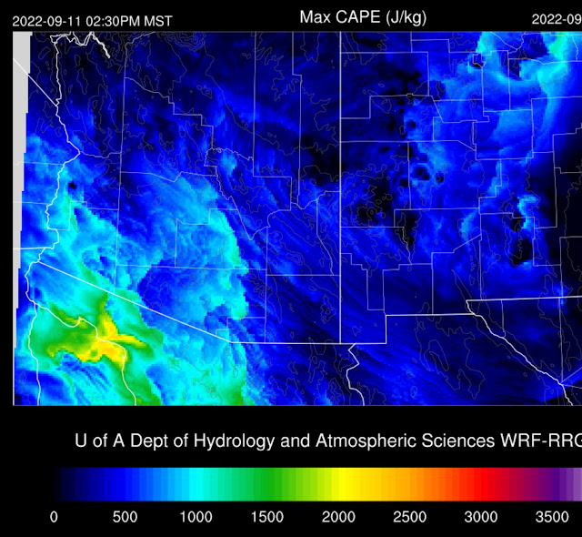
Moisture is generally around 30-35mm from Tucson to Phoenix. The cool air in the mid-levels results in a decent amount of CAPE, nearly 800 J/kg. Steering flow isn't bad, with 20 knots of SSE flow. Westerlies dominate above 500mb.
Phoenix looks similar, except for a strong subsidence inversion above 500mb. It's unclear if this will negatively affect deep convection later today.
GOES CAPE is present this morning over much of south-central Arizona. Another positive indicator for lower elevation deep convection.
Day 1
What a wild weather week it has been for the western CONUS, and now, it looks like Arizona is going to get in on the action. Moisture has increased due to the southeasterly flow around Kay, and by afternoon 850mb dew-points are favorable for deep convection from an N/S line, from about Tucson, westward. Somewhat drier air and southeasterly flow dominate far SE Arizona and into NM, resulting in only limited activity there.
CAPE mirrors the 850mb Td and is moderate from Tucson and up to Phoenix and sufficient to support deep convection.
The Tucson vertical profile looks quite good, with around 1000 J/kg CAPE, good E to SE steering, SW aloft, and even a little low-level westerly winds providing a bit of shear. There aren't any strong inversions so it should be pretty active by later in the afternoon.
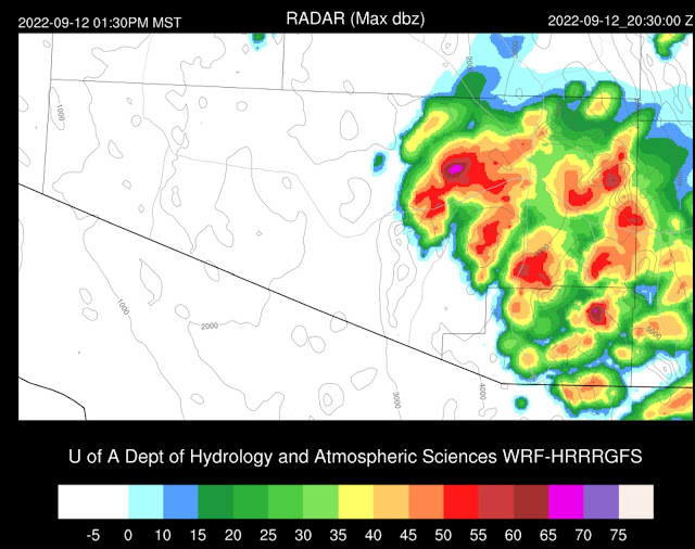
There is a unanimous agreement with all the morning runs to develop widespread storms in and around Tucson by late afternoon or early evening. However, looking closely, most runs keep most of the deep convection over the higher terrain, but a few storms are possible in the valley.
Storms move into Pinal County and eventually into Phoenix this evening. A strong outflow boundary proceeds the storms, resulting in a big dust storm.
Like Tucson, the Phoenix forecast Skew-T looks quite good as the steering is favorable, and there is a moderate amount of CAPE. The PBL could be mixed deeper, but the strong outflow boundaries might be sufficient. A few runs have low-level westerlies.
There is quite a bit of spread with the Phoenix forecast. On the low end, some runs have storms dying as they move into the valley. Others have strong storms. The middle-of-the-road forecast is some storms, but most skirting around the valley.
Day 2
A very active day is expected as moisture remains while a trough in the westerlies moves across the state. The first transition event of the season.
An upper trough that starts to move into southern Arizona also provides some favorable upper-level divergence/difluence.
PW increases somewhat and is high over much of southern and central Arizona. The low-level easterly flow also decreases, allowing moisture to move back to the east.
CAPE is relatively high, with most areas ranging from 1000-1500 J/kg.
Tucson is primed for significant early afternoon low-topped deep convection. CAPE is over 1000 J/kg, and there is some directional shear in the lower troposphere, resulting in some organization of storms and possible mini-supercells.
Some storms could be severe and may produce large hail.
Phoenix doesn't have a directional shear profile as favorable, but CAPE is good, with over 1200 J/kg. A good outflow boundary should kick off the party despite the weak inversion on top of the mixed layer.
Storm coverage continues to increase during the late afternoon hours and, like today, moves up I-10 towards Phoenix. Some of these storms are likely to be severe.
Another very strong to severe outflow boundary moves into Phoenix, probably with plenty of dust, followed by considerable deep convection.


No comments:
Post a Comment
Note: Only a member of this blog may post a comment.