The last two nights have seen large nocturnal mesoscale convective systems form over Sonora. This has resulted in a slight increase of moisture for southern Arizona as PW is now in the mid-thirties. The MCS from last night is still going over far southern Sonora this morning resulting in widespread clouds all through Sonora. Southern Arizona is also experiencing broken to overcast conditions. Cloud initializations are reasonably accurate, but the WRFNAM does burn the clouds off two quickly. The other two runs hold onto the overcast a bit long but eventually clouds burn off too.
A large inverted trough/MCV combination can be seen over much of Sonora. A second, energetic MCV is located east of El Paso. The Sonora IT was resolved in the 500mb data, but the El Paso MCV was not. The mid-level anticyclone is one again near the Four Corners, and temperatures near the center are quite high, around -4C.
All three of the 12Z initializations did a good job initializing these features, including the El Paso MCV. I was a bit concerned about the high wind speeds that were initialized at 600mb as the RR had 30 knot easterly winds just south of Nogales. Satellite imagery does indicate rapid westward movement of the mid-level clouds, so 20-30 knot winds are probably accurate.
The GFS and RR had some moderate PW errors of around 3-5mm over southern Arizona and into Mexico. The NAM was worse with 4-10mm errors. The GFS and RR initialized the situation quite well, especially considering the complexity and those are the favored runs today.
Day 1
A gulf surge is underway over southwestern Arizona which continues into the early afternoon bringing moist air into much of the southern part of the state. PW slowly increases and may be as high at the low 40's. The various runs disagree with the amount of PW with the GFS being the wettest. Weak low-level easterly flow is also present over New Mexico with quite a moisture gradient from north to south. This sets up another low-level convergence zone over southeastern Arizona, so storms are more likely there.
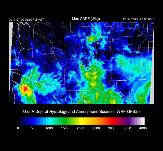
The wetter WRFGFS has more CAPE for parts of southern Arizona which is likely to result in more activity there but it hard to say which one is right.
Storms take their time getting underway this afternoon and the only active areas are the higher elevations of eastern Arizona, even in the wetter WRFGFS.
The WRFGFS late afternoon Skew-T forecast plot has a deeply mixed PBL and good mid-level steering flow of around 20 knots. CAPE isn't very impressive with only 5-800 J/kg.
Activity picks up over much of SE Arizona this evening, and the area of storms generally moves westward towards the lower elevations.
A few storms and associated outflows move into the Tucson area this evening.
While the Phoenix vertical wind profile looks good, there is only limited CAPE forecast, so it's unlikely that any activity will make it into the Phoenix area.
The model forecasts are all consistent with the lack of any activity near Phoenix, but some continue storms over far southern and/or southeastern Arizona well into the night. It appears another MCS forms over far northern Sonora aided by the Sonoran IT.
Day 2
All runs are consistent with placing the IT over the far northern Gulf of California which puts much of southern Arizona in favorable southeasterly 15-20 knot flow.
Very moist air is present over much of the state with PW over 50mm in places. Drying is underway over far eastern Arizona due to dry air advection from New Mexico.
CAPE also increases and is the highest in the WRFGFS. The big question will be how much heating with occur as extensive debris clouds are likely, especially over southern Arizona. Confidence in the Day 2 forecasts is low because of all the uncertainties.
The WRFGFS and WRFRR generally agree on developing storms over the higher terrain near Tucson and Phoenix by late afternoon.
The wetter WRGFS has plenty of CAPE to support deep convection for both Tucson and Phoenix as well as favorable mid-level steering.
Storms continue into the evening near both Tucson and Phoenix with some activity possible for both cities.


No comments:
Post a Comment
Note: Only a member of this blog may post a comment.