Previous Day
None of the 12Z models did very well as the WRFGFS and WRFRR were too active while the WRFNAM was not active enough over SE Arizona. The 15Z WRFRR(below) turned out to be the best.


Initializations
An elongated IT is located over central Arizona down into NW Sonora and is initialized OK by the various 12Z models. The high center continues to the east of Arizona putting the state in mostly south to southwest flow. Widespread clouds are across NE Arizona and the GFS and RR initialized these well while the NAM didn’t have enough coverage. The NAM is generally 2-3mm too wet most locations but the error is small enough that the correction routine should work OK. The WRFRR and the WRFGFS have initialized the best.
Day 1
CAPE is low over most of the state except for the SE.

Unfavorable SW steering is over most of the state behind the departing trough and along with warming at mid levels, deep convection is expected to be minimal today.


The only thing of interest is the tropical system that is now present SSW of Puerto Vallarta. It moves slowly west today and tonight and is in a perfect location to trigger a Gulf Surge. Somewhat surprising that NHC hasn’t named it yet as it’s still just an X on their page. I’m impressed that the various model runs over the past few days have insisted on developing this system and now, here it is. Magic! The forecast position by the WRFRR(below) is too far north and the WRFGFS is a bit better as it’s closer.

Day 2
The tropical system is SW of Cabo around midday with a classic Gulf Surge underway into Arizona. I call it “classic” as it’s a surge that extends the length of the GofC vs the more typical (at least this year) thunderstorm (MCS) driven surges.

CAPE is much improved tomorrow with moderate CAPE over much of the state. The big question will be how much low-level cooling occurred as well as how much heating there will be during the day.

The IT shears apart leaving a weak trough over Puerto Penasco which puts most of the state in light SW flow which is poor for storm motion and organization. Another negative is the very warm air in the mid-levels with temperatures around -4 to -5C.

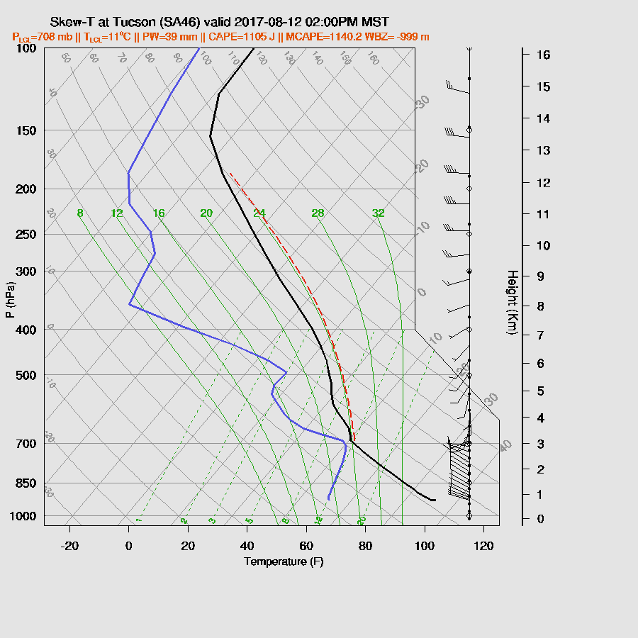
The Tucson area afternoon vertical profile forecast indicates a good amount of CAPE at around 1100J/kg. That is the only good thing as there is a cap at the top of the mixed layer with a warm layer above. Mid level steering winds are poor as they are mostly light from the SW. My guess are storms mostly over the higher terrain with a few managing to form/move into the lower elevations.
A very similar looking late afternoon Skew-T at Phoenix.

It appears only scattered storms mainly over the higher terrain of SE AZ and north central AZ during the afternoon. Tucson may get lucky and see a few storms.

Isolated activity is expected to continue into the night in some locations. A pathetic crop of storms in spite of a good surge event. Sad!

No comments:
Post a Comment
Note: Only a member of this blog may post a comment.