Previous Day
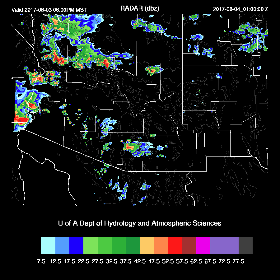
Very little storm activity was present over the lower elevations as morning clouds and showers prevented the heating needed for deep convection. Strong storms did move off the higher terrain of Yavapai and Mohave Counties into the Colorado River valley.

The 15Z WRFRRx was the better model run as it had little or no thunderstorm activity over the lower deserts. However, it did miss the heavier activity in southern Mohave County. The 15Z WRFRRx is operational now and links to it are on the Arizona WRF web page. The WRFNAM was also fairly good yesterday. The WRFGFS had too much activity in the lower deserts as it had too much heating.

Initializations
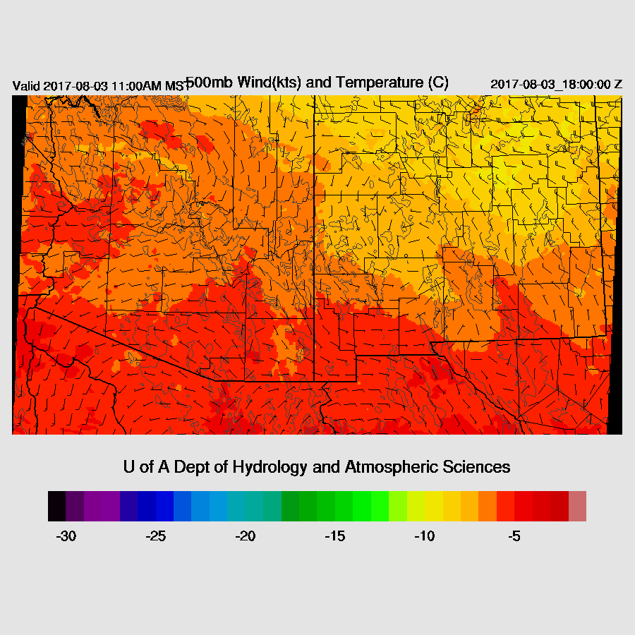
It is another complex situation around Arizona with ongoing showers between Tucson and Phoenix and extensive clouds over much of southern Arizona. The 500mb pattern is essentially unchanged from yesterday with the high center to the NW of Arizona. Unfortunately, the cooler air over NM didn’t make it to southern Arizona as it is a very warm, -4C at Tucson. A week IT is located between Tucson and Phoenix which is responsible for the morning clouds and showers. An upper trough was over Baja California Norte and moving NNW. Upper air initializations all look fine.

The RRx initialized the morning clouds were initialized as well as could be expected but the WRFRRx did develop widespread showers in the Phoenix area this morning which was too much. The NAM was poor as it did not have enough clouds over central and western Arizona and too much over SW NM. The GFS initialized clouds fairly well and the WRFGFS also developed a few showers during the morning hours more or less in the right spot between Tucson and Phoenix but developed an anomalous area of storms to the west of Tucson. The NAM had its usual wet bias in Mexico. The other initializations had only minor errors. The WRFRRx followed by the WRFGFS, have the better initializations today. Confidence is medium at best due to the complex situation.
Day 1
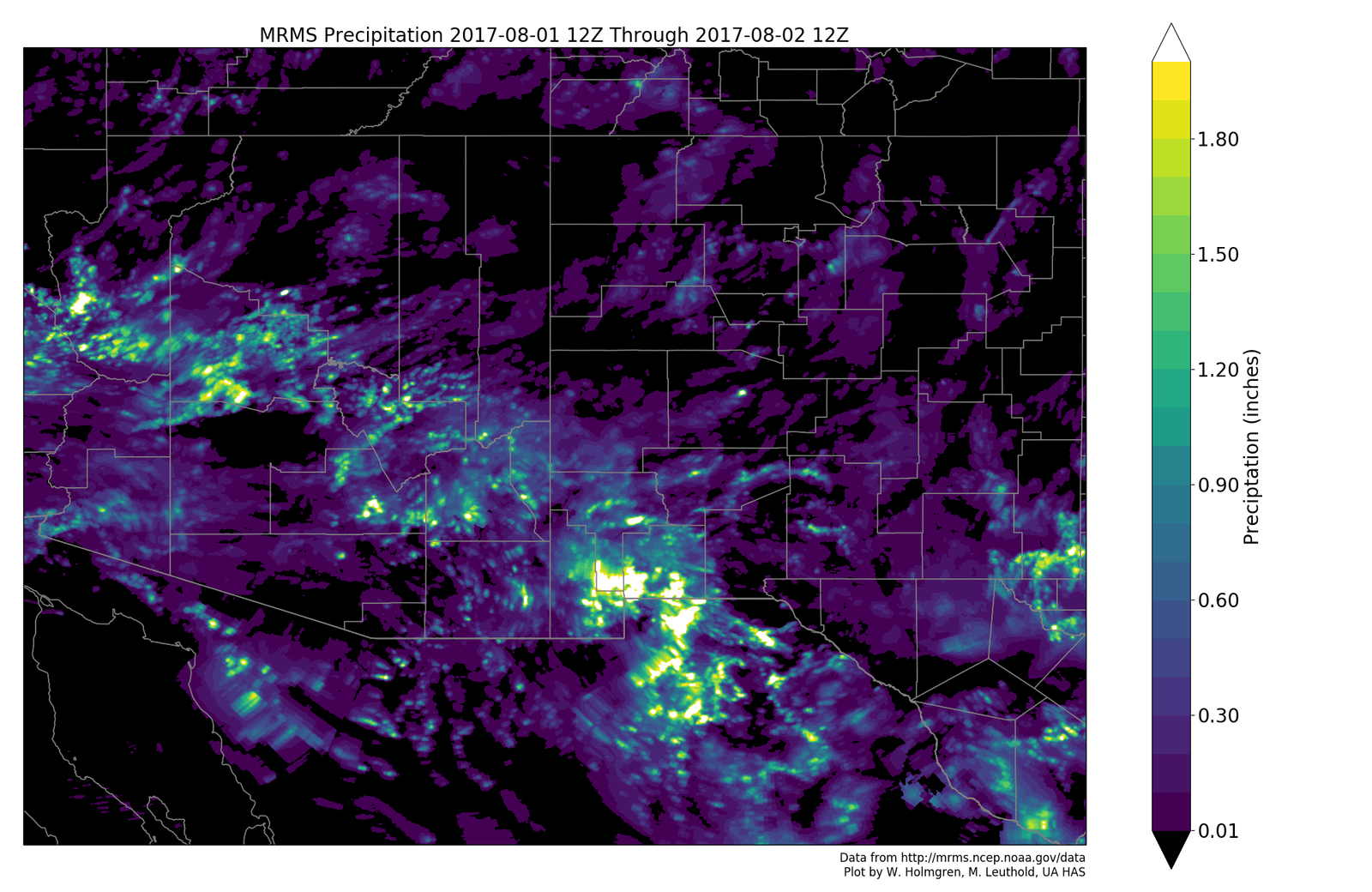
IPW continues to be near record levels over SW Arizona as a site just east of Yuma has 56mm! This moisture sticks around over central and western Arizona today while far eastern Arizona has light easterly flow which is advecting slightly drier air out of NM. Yesterday’s model runs had a bit more drying than actually occurred. This weak easterly flow may be sufficient to act as a low-level convergence zone on the westward edge. 
The southern Arizona IT moves slowly to the west and puts much of eastern Arizona in a weak east to SE mid-level flow which is not enough for any significant storm organization.

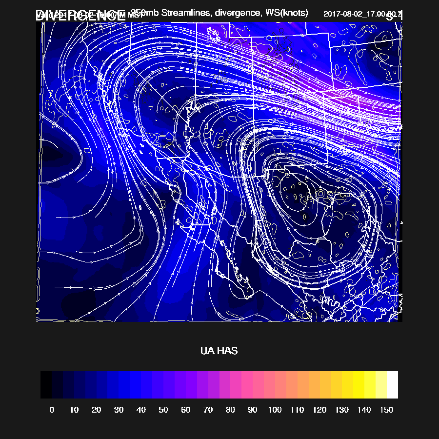
The upper trough moves northward over Arizona today with a large area of upper difluence and areas of divergence which will help whatever storms manage to form.
CAPE is moderate to high at locations to the west of the back door dry line. Any of these higher CAPE areas could see activity depending on the amount of insolation.

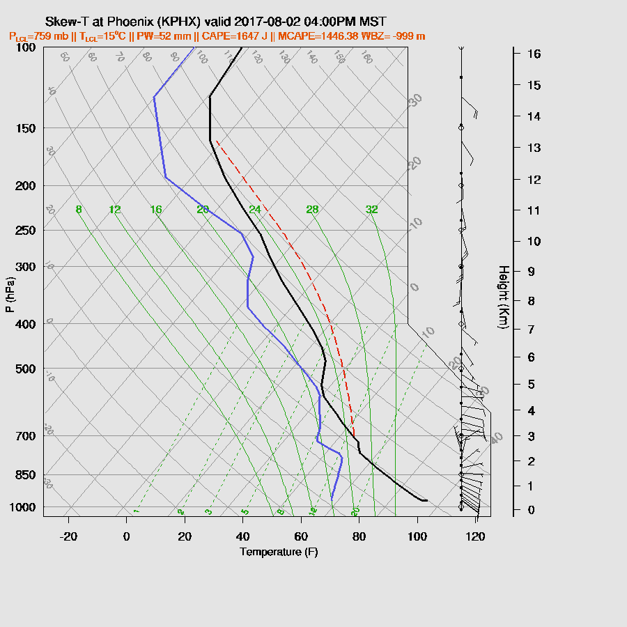
By late morning, Tucson had around 1000 J/kg along with a well mixed PBL. Mid level winds continue to be poor and Tucson is on the east side of the low-level convergence zone thus there is a slight amount of directional shear below 500mb. Going by the Skew-T, there should be activity during the afternoon in and around Tucson as the area is mostly clear and getting good heating.

The WRFRRx and WRFNAM (below) develop scattered storms over SE Arizona during the early afternoon on what appears to be the low-level convergence line. The WRFRRx is a bit to the east of Tucson which may be incorrect as the convergence line appears to be west of the city.
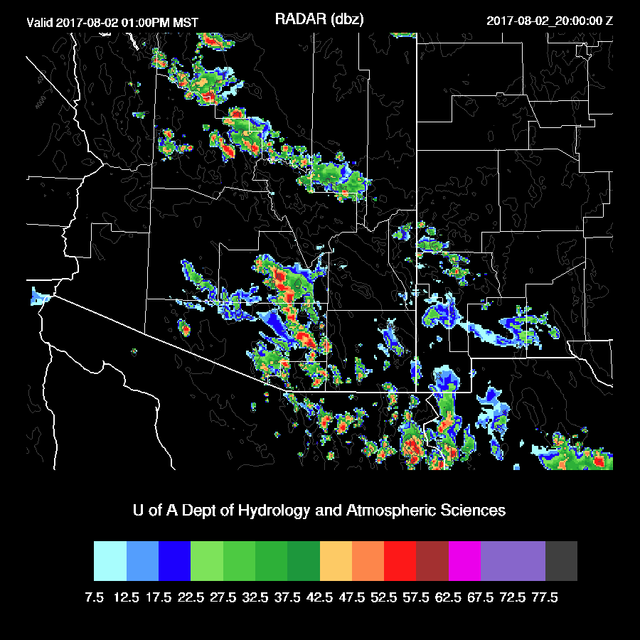
Big storms continue over SE Arizona while another line of storms moves toward the CO river in Mohave county. All three of the morning runs are quite similar thus confidence is high for these two areas.

The Phoenix area stays showery and cloudy this morning thus there will be insufficient heating for any significant activity. The WRFNAM does allow some heating this afternoon (which is probably too much) and it still doesn’t look good for Phoenix as there is a strong inversion at the top of the PBL plus another around 500mb. However with 52mm of IPW CAPE is still around 1500 J/kg, a big outflow just might be able to trigger some deep convection as is forecast by the WRFGFS.
Storms decrease over SE Arizona during the evening while deep convection continues over far western Arizona.

Day 2
It looks like the beginning of the end for widespread thunderstorm activity, at least for awhile. IPW drops tomorrow over most of the state but plenty of low-level moisture exists over most of the state as 850mb dewpoints remain high. The WRFRRx is the odd man out as it dries out much quicker than the other runs and is most likely too fast. WRFNAM below.

CAPE is moderate to high once again except for far eastern areas where drier air from NM has moved in.

There is a lot of uncertainty where the IT ends up. In general it moves slowly to the NNW thus putting much of Arizona in weak southwesterly flow which is not favorable. Usually, behind a departing IT activity is much decreased due to weak subsidence.
Afternoon storms mainly over NW Arizona.

There might be a few storms over the lower deserts during the evening.
No comments:
Post a Comment
Note: Only a member of this blog may post a comment.