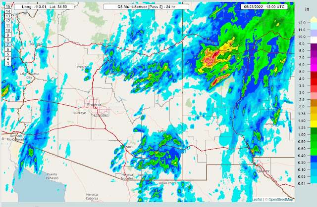
Previous Forecast
The WRFGFS and WRFRR did reasonably well, as they had the SE Arizona activity. The WRFGFS did much better along the rim and into NM, where heavy rain fell again. I have to say, I was sweating when those storms formed just west of Tucson as I thought the outflows were going to trigger deep convection in the valley, which was not in my forecast.
The dominate 500mb anticyclone has been pushed southwest by a series of northern branch troughs and is located over central Texas. The west coast cutoff low is in the process of kicking out and, as was discussed yesterday, may provide dynamics for storms in Arizona today.
TS Celia has struggled over the past day, but the NHC still calls for hurricane status in 24-36 hours. It's following in the tracks of Blas, so maybe upwelled cooler water is part of the reason. In any case, it appears to get enough to the southern Gulf of California to provide some additional moisture. Moisture has increased slowly over central and western Arizona as PW is in the low 30mm range, which isn't that great. PW has generally decreased over southeastern Arizona, probably due to the widespread activity last night.
I don't know why the SPC plot is having a problem with the CAPE calculations at Tucson and eyeballing the positive area; it doesn't look like there is much.
The Phoenix sounding is unavailable, but the view from GOES indicates a moderate amount of CAPE is present over central Arizona, as indicated by the purple areas. Thus, it looks like the potential for storms in those areas exists.
Initializations look generally accurate.
Day 1
Slight moisture advection continues for western and central Arizona today. Drier and more stable are is over far eastern and southeastern Arizona due to downsloping winds and the general decrease in moisture upstream in SW NM.
Despite a weak Gulf Surge, 850mb dewpoint temperatures are marginal for central and western Arizona and poor for SE Arizona.
Despite marginal moisture, many central and western Arizona areas have sufficient CAPE to support at least some activity.
The model runs all indicate that Phoenix may have enough CAPE, 500-900 J/kg, to support some activity, especially considering the ejecting west coast low. The wind profile is mainly unidirectional, but there is some weak speed shear. The big message from the Skew-T is the deep mixed layer, which will result in some strong winds and widespread blowing dust. Maybe even the H-word.
Model runs develop storms over the higher terrain of south-central Arizona by later in the afternoon.
Storms move/develop in the Phoenix area by late afternoon to early evening.
It looks unlikely for a classic I-8 haboob as storms and outflow boundaries are steered to the NE. Storms are also not well organized or strong, so no cold pool or large-scale outflow boundaries are expected. Still, a few storms could generate strong winds and significant areas of blowing dust.
Scattered weak storms continue into the evening.


No comments:
Post a Comment
Note: Only a member of this blog may post a comment.