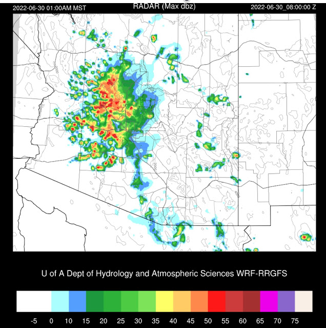
Previous Forecast
It mainly was a down day except for some strong to severe storms between Prescott and the Colorado River valley.
All runs were generally correct in the location and timing. The WRFHRRR, as usual, didn't have enough precipitation.A lot of data was missing at 12Z. Nothing from Mexico and Tucson and Flagstaff are missing. The center of the CONUS-wide 500mb anticyclone is located over the 4-corners, which is a favorable location for storm propagation from the higher terrain of the Rim and the White Mountains into the lower deserts.
PW has increased over the last 12 hours over western and central Arizona and ranges from 35-38mm. Southeastern Arizona has decreased and is mainly in the 30-35mm range. Phoenix CAPE looks fair, at 562 J/kg, and the wind profile is moderately favorable for steering storms from the higher terrain. The Tucson sounding was missing, but going from the Phoenix sounding, Tucson might have problems again with anvils advecting over the city from deep convection in central Pima County.
Initializations
The overall synoptic/mesoscale situation is straightforward as there are no significant areas of clouds over the state and no obvious cyclonic circulations. WV imagery confirms there are no apparent waves either. There are two weak MCVs in northern Sonora, one quite close to Nogales. These are associated with clouds and a few showers and are slowly moving NW. There is some GOES-derived CAPE over south-central Arizona up towards Flagstaff. Many times, this is a good indicator for later deep convection. Most initializations had some sort of weak cyclonic circulation over northern Sonora. Cloud amounts and locations were well initialized, except by the 12Z HRRR. It was too clear over far southern Arizona and northern Sonora. Generally, initializations are good, except for the 12Z HRRR. The GFS and the RR should perform well today.
Day 1
Moisture continues to advect into much of the state as a weak surge continues from the Gulf of California and is more than enough to support deep convection.
850mb dewpoints also look good, with most areas at or above 10C. Far SE Arizona has drier air advecting in from NM. Thus activity will be less there. However, this ESE flow has set up a low-level convergence over the Pima/Cochise County line, so this may be a favored spot for storm development.
CAPE is relatively high over much of western and central Arizona by early afternoon and isn't too far off from the observed GOES CAPE from this morning. With some areas at or above 1500 J/kg, there will likely be some very strong to severe thunderstorms.
The morning runs are remarkably consistent on developing afternoon storms, some potentially severe, over the high terrain around Flagstaff, and the high terrain of southeastern Arizona. As of 17:05Z, storms are already underway over the highest terrain of SE Arizona. I hear thunder over the Chiricahuas, which is always a good sign for an active day for SE Arizona.
Phoenix also looks favorable for evening storms. The forecast vertical profile looks much like Tucson: well-mixed PBL, low-level shear, OK mid-level steering, and upper flow steering anvils away from storm motion. There are the first Skew-T profiles of the season that actually look like a typical monsoon storm setup.
Most runs develop strong storms in and around the Tucson area by late afternoon. Storm motion is slowly to the NW.
Outflow boundaries and thunderstorms move down I-10 and into Phoenix during the evening hours. All runs are consistent with this solution, so confidence is high. The situation looks like a classic Tucson to Phoenix southeasterly steering event.
A few of the storms could be near severe, with mainly strong winds and blowing dust.
Storms continue to move NW and cover quite a bit of west-central Arizona by late evening. It looks like WRF tries to spin up an MCS in some of the runs.
Day 2
After all the activity today, tomorrow is likely to be mostly inactive, at least for much of the state, due to the cooling and stabilization of the atmosphere. It remains quite moist with PW in the 30-38mm range over much of the lower elevations.
Only scattered activity is expected over the higher terrain.


No comments:
Post a Comment
Note: Only a member of this blog may post a comment.