Previous Forecast
It was a very active afternoon (for June!) for much of southcentral to northcentral Arizona. Strong to severe storms (2 severe wind reports) moved into the Phoenix area during the late afternoon hours. A fair amount of rain fell north of Phoenix, both in the afternoon and in the early morning.
All runs had the right idea to develop storms over the higher terrain of central Pima and southern Pinal Counties and then move them into the Phoenix area. In fact, the previous day's forecast was similar, and IMO was an excellent forecast so far in advance. Where WRF fell down was the amount of precipitation, especially south and north of Phoenix. Most runs could not pick up on the early morning activity north of Phoenix. I do not understand why the WRFHRRR is always the worst forecast. It does an OK job of when and where, but the amounts are always less than the other two initializations. I've double-checked the namelist to ensure the runs are using the exact same settings, and they are.

Discussion
The center of the CONUS anticyclone is over northern Texas, with troughs near each coast. Arizona is not in a traditional monsoon flow pattern, despite storms occurring as SW flow continues to be present over most of the state. We've been lucky that Blas moved close enough to allow moisture to advect into the state. The situation over Arizona and Sonora is complicated as there is a larger scale inverted trough, seen in the 12Z data, plus a strong MCV leftover from an overnight MCS in Sonora. This may have been the first big one of the year.
PW has increased somewhat for Arizona, with values around 30 to 35mm. A weak Gulf Surge is underway over western Arizona, partially induced by the outflow from the Sonora MCS. Regarding moisture, Celia looks better organized and is still on a WNW trajectory. Its associated moisture is already entering the lower GofC where PW is over 50mm and should eventually work its way into Arizona.
Both the Tucson and Phoenix vertical profiles are mediocre. Little or no CAPE and marginal moisture. Tucson's wind profile is bad, with light and variable winds below 500mb and southwesterly flow above.
At least Phoenix has a little directional shear, but like Tucson, little or no CAPE.

Initializations
You don't need an animation to see where the MCV is located! Clouds and ongoing showers are present north of Phoenix due to the forcing of the ejecting west coast trough, while a band of clouds is present over far SE Arizona and into NM. The initializations are struggling with the activity north of Phoenix. The 6Z WRFGFS completely missed it while the others had something, but not enough. The initializations are also struggling with the MCV/IT. Only the 9Z and 12Z RR had a discreet closed rotation. The others initialized a larger scale IT. I like the various RR initializations today.

Long-time readers may have noticed I no longer talk, or even look at, the IPW errors. The below plot (GFS) shows the difference between the initialization and observed IPW from Suominet. There are only minimal errors, even in Mexico, and this is the case for every initialization, except for the NAM. Remote sensing of IPW and proper initialization of the GFS, RR, and HRRR have come a long way. The NAM has been removed from the model rotation as it was frozen years ago before proper assimilation of IPW.
Day 1
The Gulf Surge continues into the afternoon, advecting moisture into mainly western Arizona, but most of the southern 1/2 of the state has decent moisture, especially considering it's still June.
850mb dewpoint temperatures are more favorable for activity as many areas are around 10C.
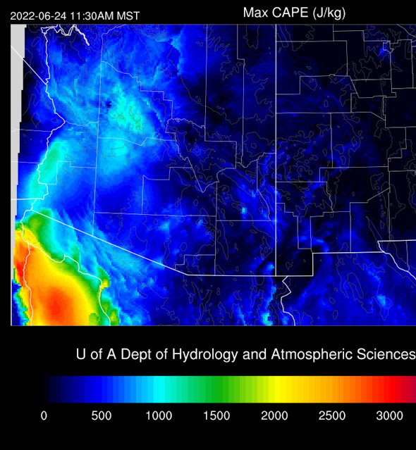
Early afternoon CAPE is quite high over western Arizona, which will result in quite a bit of afternoon activity over the higher terrain. Much of eastern Arizona has minimal amounts, so it doesn't look like it will be active there today. All runs are similar in their solutions, so confidence is high.
Activity is present over the higher terrain of NW and NC Arizona during the afternoon, while the lower elevations and southern Arizona are mainly quiet.
Most runs, once again, develop strong storms late this afternoon over the higher terrain of the O'odham Nation.
While CAPE isn't great and is similar to yesterday, it may be sufficient to support storms in and around Phoenix again today. Steering winds are quite light. Thus storms will need to form on outflow boundaries to propagate. A good OFB should be able to kick off activity in Phoenix as the PBL is reasonably well mixed by later in the afternoon.
From the model forecasts, it seems to be a 50-50 proposition for Phoenix, and the general message is fewer storms than yesterday.
A few runs develop evening activity for Tucson, so there is some hope. Some storms may also continue into the late evening in the Phoenix area.
It could happen in Tucson as CAPE increases to around 3-500 J/kg, and outflow boundaries move in from the west.
It seems WRF has a low bias for precipitation amounts, so some higher elevations may see more than an inch. Lower elevation amounts are generally expected to be light.
250mb indicates southern Arizona is under a weak entrance region and general troughiness, providing some upper-level support.
Day 2
I've run out of time, so there will be no detailed day 2 discussion. Saying that, it looks like less activity as moisture decreases tomorrow except for southwestern Arizona, where moisture is still high.


No comments:
Post a Comment
Note: Only a member of this blog may post a comment.