Previous Forecast
This was one of the best forecasts of the season so far. Strong storms developed along the Cochise/Pima border and spread to the east, nearly identical to the forecasts. Later, showers and a few storms developed over western Arizona as the old midlevel circulation of Blas moved north. The WRFGFS runs were a bit better for eastern Arizona as they had more widespread precipitation. No run could fully predict the amounts and extent of the heavy rain in west-central NM. Some parts of NM have received 4-5 inches during the past few days.
Discussion
A 500mb anticyclone continues to dominate the CONUS. The west coast cutoff low has dropped slightly to the south and has had some moisture wrap into it, setting off thunderstorms north of L.A. A weak trough, the remnants of Blas, is located over western Arizona.
The SSEC TPW product indicates significant drying over southeastern Arizona and into Sonora, verified by GPSIPW sensors. TS Celia continues to slowly strengthen and is moving to the WNW.
The SSEC TPW product indicates significant drying over southeastern Arizona and into Sonora, verified by GPSIPW sensors. TS Celia continues to slowly strengthen and is moving to the WNW.
Tucson's 12Z sounding does have quite a bit wetter lower troposphere and more (elevated) CAPE compared to yesterday. Winds below 500mb are mainly weak from the SE, so vertical shear isn't as favorable. This is quite a bit worse compared to the forecast from yesterday for today. The PBL has also cooled some, with a lot of weak inversions and a stronger inversion above 500mb. As it's sunny over much of southern Arizona, there may be enough heating to develop deep convection. "Maybe" is the keyword.
Despite the drying seen from surface and satellite, Some CAPE is present over much of SE Arizona.
Initializations
Clouds were initialized well. The GFS seems to have the better initialization of the CAPE over SE Arizona.
Day 1
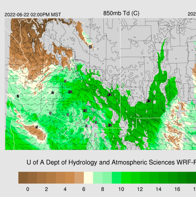
Due to the strong subsidence noted on the satellite imagery over SE Arizona, it's a tough day. The 850mb dewpoints start out relatively high this morning over SE Arizona but decrease during the afternoon. However, there is still quite a bit of low-level moisture in SW NM, which continues to advect into southeastern Arizona, resulting in dewpoints around 10-12C.
Despite the drying, CAPE is still sufficient to support storms over much of southeastern Arizona.The various runs disagree on how much drying occurs in the Tucson area. The WRFGFS holds onto 32mm of PW by afternoon, resulting in 12-1800 J/kg of CAPE. The WRFRR is in the middle (below) with 29mm of PW and 5-700 J/kg. The vertical wind profile has some weak directional shear, so storms could have some organization.
There is little agreement between the morning runs. The WRFHRRR has only isolated activity over far SE Arizona, while the 9Z WRFRR looks almost like yesterday for SE Arizona. In the middle are the WRFGFS and 12Z WRFRR, with a few storms for mainly Cochise County. Quite a big change from yesterday's runs which had significantly more activity. It shows how difficult it is to forecast more than a day in advance during the monsoon season.
Day 2
It's shocking to see how much moisture is over the SW US for June 23nd! Moisture has moved as far north as the Bay Area! PW over Arizona is mainly in the mid-30 mm range.
Some runs have activity as far north as the Phoenix area. As CAPE is only low to moderate, storms are mainly expected to be on the weak side. In any case, June monsoon rain is rare, so anything is a bonus.
Much of this increase in activity appears due to the west coast cutoff, opening up, and ejecting across NV. Arizona is under the right entrance region for the departing jet, favorable for upper divergence.


No comments:
Post a Comment
Note: Only a member of this blog may post a comment.