Initializations
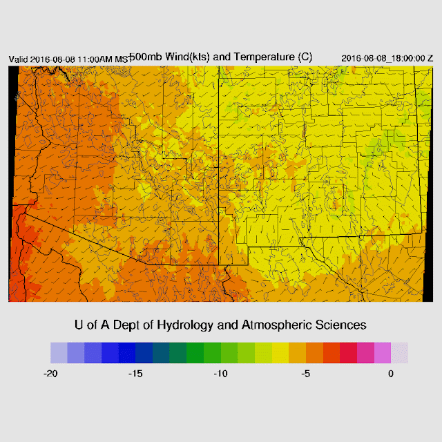
The big story is Javier as it moves to just west of southern Baja over the next few days. The 12Z NAM has initialized it too weak with only 20 knots or so 10m winds while NHC has it at 45 knots. The RR and GFS have the intensity about right and all three have the location about right.
The 500mb center is located somewhere over Texas while a strong trough with a closed center is located along the west coast causing westerly flow all across Arizona.
The 12Z RR is struggling in the area of Javier as much of that area was initialized too wet. The NAM was a bit better while the GFS was quite good.
Overall, the model initializations look good with the favorite being the WRFGFS. The WRFNAM may have issues beyond today due to the poor intensity of Javier.
Day 1
The gulf surge is underway during the day with quite strong low-level flow up the gulf. Moisture amounts around Javier are very high, above 60mm. Enough moisture is present over the southeastern 1/3 of the state for afternoon storms.
CAPE is very high in SE Arizona so I expect that part of the state to be very active with deep convection starting early as full heating is being realized. The odd man out is the WRFRR as it has lower CAPE over SE Arizona.
500mb flow is weak from the SW with some slightly lower temperatures over eastern Arizona, thus the better CAPE. So, another day of storms, mainly over the higher terrain, which doesn't move much, but drops very heavy rain.
Deep convection is restricted to mainly the eastern third of the state this afternoon.
It's possible for a few storms to form around the Tucson area during the late afternoon as there is some CAPE available, but with weak steering, storms will be unorganized and short-lived.
Day 2
Finally, the weather gets interesting again. The various model runs bring Javier to the NW but with some significant differences. For example, the 6Z WRFGFS keeps it offshore of the west coast of Baja, but the 12Z WRFGFS makes landfall on the far southern tip which is also similar to the 12Z WRFRR. The WRFNAM really struggles to get the system spun up and then jogs to the right and moves it up the GofC! The official NHC track is offshore like the 6Z run, but perhaps it's going onshore instead which will result in a quick reduction in intensity which might decrease the intensity and longevity of the surge.
With the unusual track of the WRFNAM, moisture does not increase as quickly as in the WRFGFS. The WRFGFS has a strong surge underway tomorrow with IPW values in southern Arizona approaching 40mm.
CAPE also increases and is very high over southern Arizona, especially around the Tucson area. As the track of Javier is somewhat in question, the forecast confidence for Day 2 is low. Saying that, looking at the 6Z runs with a more westerly Javier track, IPW and CAPE are similar to the 12Z WRFGFS so there is some run to run consistency.
A typical day 1 surge vertical profile is seen at Tucson with a shallow, very moist, and slightly cooled PBL with very high CAPE. Steering winds are slightly less unfavorable as mid-level flow, what there is of it, is southeasterly. Fall is present above 400mb with fairly strong SW flow.
Deep convection forms over the higher terrain of Pima and Santa Cruz counties during the afternoon. Outflows just don't seem strong enough to trigger deep convection in the Tucson area, at least in the WRFGFS. However, the atmosphere is primed and it won't take too much to set off deep convection.
The WRFGFS keeps deep convection mainly over the higher terrain and it skirts around the Tucson area.
Phoenix is also close to seeing some deep convection. Around 1000 J/Kg of CAPE with much higher lurking nearby as well as a deeply mixed PBL. There is a bit of an inversion to break through at the top of the PBL with much drier air aloft.
Storms do try to move off of the higher terrain to the south into the Phoenix area, but they die out as they do. Quite a letdown, especially as earlier runs were so active, but that has been typical this year.
Javier continues up along the coast of BCS and continues to weaken while the southerly flow continues up the GofC. With so much moisture entering the state, it once again becomes possible for deep convection to form just about any time.


No comments:
Post a Comment
Note: Only a member of this blog may post a comment.