Previous Day
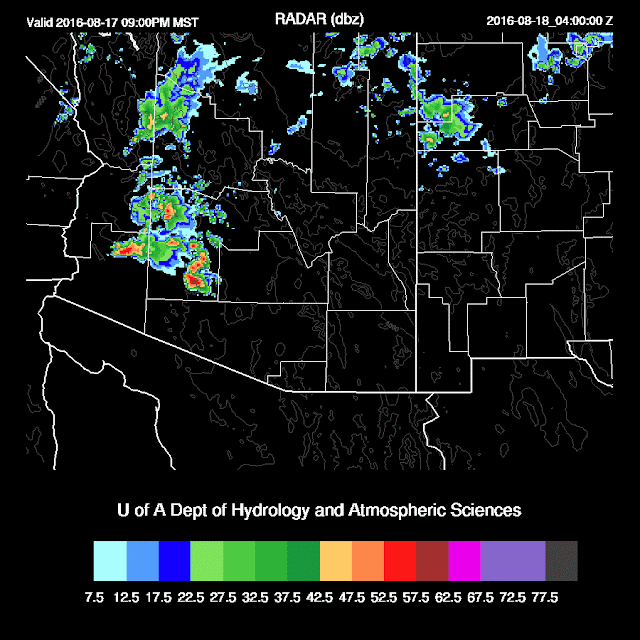
The WRFNAM and GFS made good forecasts as quite a bit of activity was present over central and southern Arizona during the late afternoon and night. The WRFGFS was close to having activity in the Tucson area as it had scattered storms over the mountains and strong outflows into the valley. All runs did miss the isolated activity around Phoenix early this morning. Both models were a bit late developing the convection that formed to the SW of Phoenix. Too bad there wasn't more moisture/CAPE in Phoenix as outflows intersected over the valley around 6pm.

Initializations
There was an area of clouds leftover from the Phoenix activity which was initialized OK by the RR and NAM. The rest of the state was clear so a simple setup this morning. 500 and 700mb 12Z maps indicate the high center is somewhere over northern Arizona and no obvious ITs were seen. At first, I missed this feature as I'm still thinking 'summer' and watching for troughs in the easterlies. There is a shortwave trough over the southern Sierra Nevada in California. Initializations look fine. IPW initialization was good except for the RR which was too wet over the southern GofC. Overall, there are no major initialization errors and if I had to choose, I'd go with the WRFNAM just because it's been performing the best this summer.
Day 1
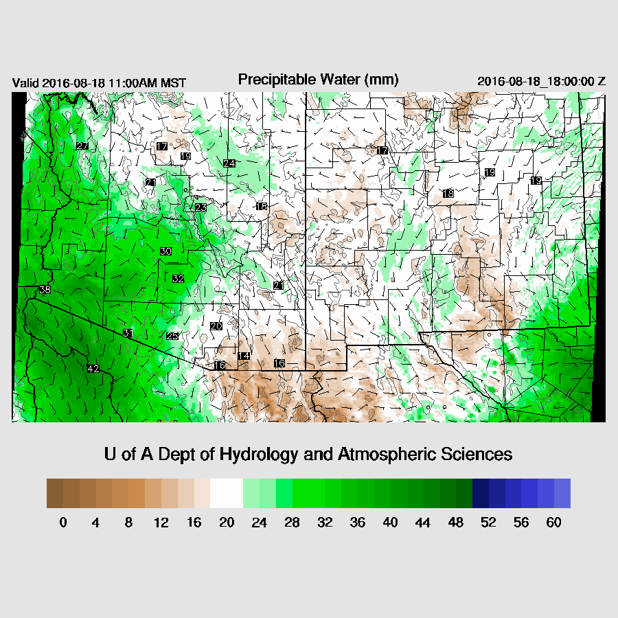
A grim situation for much of eastern and central Arizona due to very dry easterly/southeasterly flow out of NM. This dry air is due to subsidence on the south side of a 700mb high located in Kansas. Moisture advection continues up the GofC into SW Arizona.

A bit of CAPE from around Flagstaff to the NW and that's probably the only location that will see much activity. Deep convection forms by early afternoon.

During the early evening, low-level moisture increases across southwestern Arizona.

A few strong storms develop in the WRFGFS during the evening and move into western Maricopa county. These storms weaken, but continue throughout the night. They appear to be supported by part of the trough in the westerlies that moves into western Arizona and an area of upper divergence which over much of the northern 1/2 of the state.
The same for the WRFNAM, but later and farther to the west.

Day 2
Morning activity is possible due to the increased moisture and upper support in and around the Phoenix area.

Quite cool air continues over the state with much of northern Arizona around -10C, creating steep lapse rates as well as moderate CAPE. Moisture increases over the western 1/2 of the state as the flow from the south increases and the dry easterlies weaken.


Ongoing showers and clouds could impact heating tomorrow over the western 1/2 of the state. However, it appears much of the activity will be forced by the trough, weak upper divergence, and the jet streak located over western Arizona.
 The Phoenix wind profile looks interesting as it exhibits veering with height, however, wind speeds are quite light. A moderate amount of CAPE is present due to the moisture increase in lower levels. The moisture also causes a weak capping inversion.

Much of northern Arizona is quite active during the afternoon with some very strong storms present. With the cooler air aloft, hail is a possibility with some storms.
By late afternoon, the WRFNAM has quite a few strong storms underway with a couple severe, from Phoenix westward.

Some storms produce very strong to severe winds during the late afternoon into the evening, especially over western Arizona.

The WRFGFS areal coverage of storms is less than the WRFNAM and keeps most deep convection to the west and north of Phoenix. What looks likely is that western Arizona will have an active late afternoon and evening as the WRFGFS also has strong/severe storms in that area.
The WRFNAM and GFS made good forecasts as quite a bit of activity was present over central and southern Arizona during the late afternoon and night. The WRFGFS was close to having activity in the Tucson area as it had scattered storms over the mountains and strong outflows into the valley. All runs did miss the isolated activity around Phoenix early this morning. Both models were a bit late developing the convection that formed to the SW of Phoenix. Too bad there wasn't more moisture/CAPE in Phoenix as outflows intersected over the valley around 6pm.

 |
| WRFGFS |
 |
| WRFNAM |
There was an area of clouds leftover from the Phoenix activity which was initialized OK by the RR and NAM. The rest of the state was clear so a simple setup this morning. 500 and 700mb 12Z maps indicate the high center is somewhere over northern Arizona and no obvious ITs were seen. At first, I missed this feature as I'm still thinking 'summer' and watching for troughs in the easterlies. There is a shortwave trough over the southern Sierra Nevada in California. Initializations look fine. IPW initialization was good except for the RR which was too wet over the southern GofC. Overall, there are no major initialization errors and if I had to choose, I'd go with the WRFNAM just because it's been performing the best this summer.
Day 1
A grim situation for much of eastern and central Arizona due to very dry easterly/southeasterly flow out of NM. This dry air is due to subsidence on the south side of a 700mb high located in Kansas. Moisture advection continues up the GofC into SW Arizona.

A bit of CAPE from around Flagstaff to the NW and that's probably the only location that will see much activity. Deep convection forms by early afternoon.

During the early evening, low-level moisture increases across southwestern Arizona.

A few strong storms develop in the WRFGFS during the evening and move into western Maricopa county. These storms weaken, but continue throughout the night. They appear to be supported by part of the trough in the westerlies that moves into western Arizona and an area of upper divergence which over much of the northern 1/2 of the state.

The same for the WRFNAM, but later and farther to the west.

Day 2
Morning activity is possible due to the increased moisture and upper support in and around the Phoenix area.

Quite cool air continues over the state with much of northern Arizona around -10C, creating steep lapse rates as well as moderate CAPE. Moisture increases over the western 1/2 of the state as the flow from the south increases and the dry easterlies weaken.

Ongoing showers and clouds could impact heating tomorrow over the western 1/2 of the state. However, it appears much of the activity will be forced by the trough, weak upper divergence, and the jet streak located over western Arizona.


Much of northern Arizona is quite active during the afternoon with some very strong storms present. With the cooler air aloft, hail is a possibility with some storms.
 |
| WRFNAM |
By late afternoon, the WRFNAM has quite a few strong storms underway with a couple severe, from Phoenix westward.

Some storms produce very strong to severe winds during the late afternoon into the evening, especially over western Arizona.

The WRFGFS areal coverage of storms is less than the WRFNAM and keeps most deep convection to the west and north of Phoenix. What looks likely is that western Arizona will have an active late afternoon and evening as the WRFGFS also has strong/severe storms in that area.
 |
| WRFGFS |
No comments:
Post a Comment
Note: Only a member of this blog may post a comment.