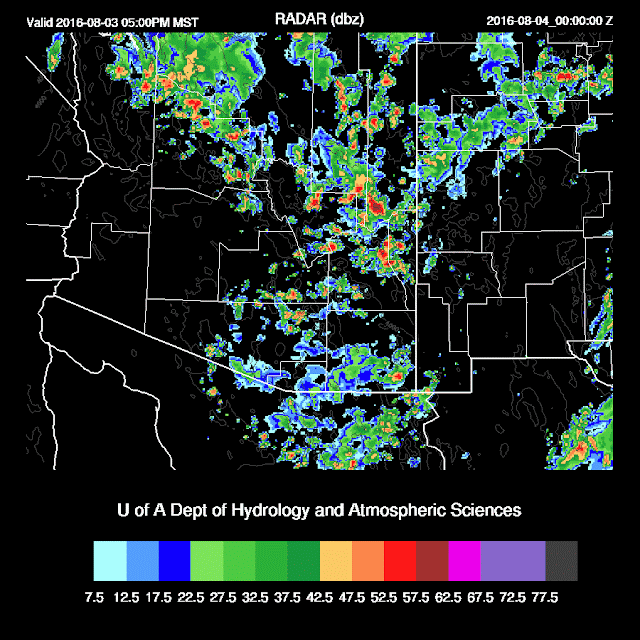
As expected, model performance was quite poor. The sun was able to come out around the Phoenix area and storms formed as outflows from the south and north were able to collide, resulting in very heavy rain. Some runs did have deep convection in and around Phoenix during the late afternoon and early evening but were not intense enough.
Initializations
A somewhat less complicated situation as clouds and showers are decreasing during the morning rather than increasing. A weak cyclonic circulation was noted in the visible imagery over Gila county. Upper air maps indicate this feature is at around 700mb and they indicate 500mb temperatures are from -6 to -4C. All three 12Z initializations have this feature plus another over far NW Sonora. Both are very weak.
As usual, the 12Z initializations have little or no morning clouds. The 0 and 6Z WRFNAM both have a fair amount this morning so perhaps they may be of more use and looking at how they are doing with surface temperatures so far, show that both are pretty close to observed. Also, if clouds can burn off, the 12Z runs might be OK.
IPW initializations were very good with all initializations.
I think that the 6z WRFNAM might do OK today. Also, the 12Z WRFNAM doesn't seem too far off, except for northern Arizona where it didn't pick up on the ongoing activity there. Confidence is higher than yesterday, but still low overall.
Day 1
High moisture and CAPE are again present at Tucson and Phoenix and it's not going to take much heating to get deep convection going in and around either location. 12Z soundings are light and variable so again, very heavy rain is the main threat. Wettest air continues over central and eastern Arizona where 850mb dew-points are from 15 to 17C!
Moderate to high CAPE is forecast over the eastern two-thirds of the state thus deep convection could form just about anywhere. More stable air is over western Arizona which may work its way east over the next few days.
The morning sound at Tucson didn't look that worked over and had l400 J/Kg of MLCAPE. Just going by that, even some heating should set off some deep convection. By late afternoon, the model runs still haven't formed deep convection, but it could happen anytime with a sounding this wet and close to the LFC. Winds continue to be light and variable thus individual storms will drop very heavy rain along with isolated high winds from wet microbursts.
The situation is the same in Phoenix as their morning sounding has lots of CAPE and isn't too worked over either. Like yesterday, if the situation is just right (outflows moving into the valley from nearby mountain convection, some storms may again form as late afternoon CAPE is high and the PBL is deeply mixed.
Most of the model runs do not develop deep convection over Tucson or Phoenix this afternoon or evening. Still, the potential is there so it could happen, but it's more likely that not much happens. The WRFGFS is the most aggressive, but it only has weak storms around the Tucson and Phoenix areas late this afternoon.
Day 2
Same old story at 500mb as temperatures around -4 to -6C and light winds. Note the trough over the far NW part of the domain as that is going to decrease moisture in a few days. Weak cyclonic circulations continue to spin slowly over Arizona and over the northern GofC.
Moisture decreases slightly, but still very wet. CAPE continues to be sufficient over mainly SE Arizona for deep convection. Drier air continues to move slowly to the east, decreasing CAPE.
Again, it's very difficult to say when or where storms may develop where CAPE and moisture are high and because of possible clouds. Tucson continues to be at risk for deep convection most any time as CAPE remains above 1000 J/Kg tomorrow.
Hard to say about Phoenix as the models disagree with moisture and CAPE at Phoenix. The WRFGFS keeps moisture and CAPE high while the WRFNAM has less as mid-level winds become southwesterly and begin to bring in drier air.
 |
| WRFNAM |


No comments:
Post a Comment
Note: Only a member of this blog may post a comment.