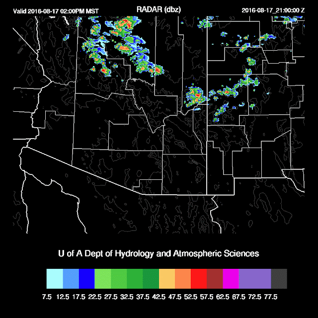
How fast things can change. I wasn't really paying any attention to the model runs this morning when I decided to take a look around 17:30Z. This is another example of how bad the day 2 forecasts can be in the monsoon season as the more recent runs are much more active around Tucson and Phoenix today.
Initializations
Mid level flow continues to be weak with no obvious cyclonic circulations at 500mb except for an IT over the Big Bend of Texas. The 700mb map indicates a trough over the Four Corners area that was initialized well by all models. This feature isn't seen in the winds or heights at 500mb, but there is an area of cooler air, around -10C, and clouds are associated with this feature. There is also a weak 700mb high over central Arizona which is producing favorable NE steering flow over SE Arizona. There are no major IPW initialization errors. All runs have initialized well and there are no clear favorites.
Day 1
Low-level moisture advection continues with even a bit of a gulf surge ongoing. It's shallow as seen on the 14Z Yuma sounding. However, at 850mb, the atmosphere as dried since yesterday. Just looking at available moisture, one would think that this would be a mostly down day. Dry air is present over far western Arizona in SW flow and over eastern Arizona in the easterly flow. I wouldn't think 8 to 10C dewpoints that are across central Arizona would be enough to support deep convection.

CAPE is low to moderate over the higher elevations, so I can see that area being active. It does appear enough CAPE is present in Maricopa and Pinal counties to support some deep convection over the higher elevations there.

Deep convection develops by around noon over the higher elevations and by later in the afternoon, it's moved slowly to the south with activity quite close to Phoenix. Note that the WRFNAM is a few hours earlier with this nearby activity.
The PBL is deeply mixed with a pronounced inverted V profile at Phoenix during the late afternoon as the outflows move through. However, not enough CAPE/moisture is present to support deep convection.

The 12Z runs are all predicting strong thunderstorm outflow winds into Pinal and Maricopa counties during the late afternoon and early evening. The timing is considerably different as the WRFNAM has outflow winds into Phoenix quite early, around 0Z while the others are around 8pm. Confidence is high for this outflow wind event.
The WRFGFS and WRFNAM do develop some storms in the lower elevations of Maricopa, Pinal and Pima counties triggered by the strong outflows. Activity appears to remain just west of Tucson as moisture is not sufficient there. As Bob Maddox said, this looks more like June that mid-August!

Day 2
Dry air continues to advect into eastern Arizona. Weak southerly flow out of the GofC continues to keep SW Arizona fairly moist, but it looks like the dry air is winning the battle.

Activity is mainly around the Flagstaff area tomorrow.
Initializations
Mid level flow continues to be weak with no obvious cyclonic circulations at 500mb except for an IT over the Big Bend of Texas. The 700mb map indicates a trough over the Four Corners area that was initialized well by all models. This feature isn't seen in the winds or heights at 500mb, but there is an area of cooler air, around -10C, and clouds are associated with this feature. There is also a weak 700mb high over central Arizona which is producing favorable NE steering flow over SE Arizona. There are no major IPW initialization errors. All runs have initialized well and there are no clear favorites.
Day 1
Low-level moisture advection continues with even a bit of a gulf surge ongoing. It's shallow as seen on the 14Z Yuma sounding. However, at 850mb, the atmosphere as dried since yesterday. Just looking at available moisture, one would think that this would be a mostly down day. Dry air is present over far western Arizona in SW flow and over eastern Arizona in the easterly flow. I wouldn't think 8 to 10C dewpoints that are across central Arizona would be enough to support deep convection.

CAPE is low to moderate over the higher elevations, so I can see that area being active. It does appear enough CAPE is present in Maricopa and Pinal counties to support some deep convection over the higher elevations there.

Deep convection develops by around noon over the higher elevations and by later in the afternoon, it's moved slowly to the south with activity quite close to Phoenix. Note that the WRFNAM is a few hours earlier with this nearby activity.
 |
| WRFNAM |
The PBL is deeply mixed with a pronounced inverted V profile at Phoenix during the late afternoon as the outflows move through. However, not enough CAPE/moisture is present to support deep convection.

The 12Z runs are all predicting strong thunderstorm outflow winds into Pinal and Maricopa counties during the late afternoon and early evening. The timing is considerably different as the WRFNAM has outflow winds into Phoenix quite early, around 0Z while the others are around 8pm. Confidence is high for this outflow wind event.
 |
| WRFNAM |
 |
| WRFGFS |
The WRFGFS and WRFNAM do develop some storms in the lower elevations of Maricopa, Pinal and Pima counties triggered by the strong outflows. Activity appears to remain just west of Tucson as moisture is not sufficient there. As Bob Maddox said, this looks more like June that mid-August!

Day 2
Dry air continues to advect into eastern Arizona. Weak southerly flow out of the GofC continues to keep SW Arizona fairly moist, but it looks like the dry air is winning the battle.

Activity is mainly around the Flagstaff area tomorrow.

No comments:
Post a Comment
Note: Only a member of this blog may post a comment.