Random!
Initializations
Anther complex morning with widespread clouds and some showers. Of course, model initializations do not have nearly enough clouds and showers. Clouds are rapidly dissipating over SE Arizona, but clouds and showers continue between Tucson and Phoenix and model runs are warmer than observed at both Phoenix and Tucson.
A mid level circulation is over NW Arizona and another upper IT was seen in the WV over far SW NM back towards far southern TX. Another was seen over NE Arizona which didn't really appear on the morning analysis. 300-250mb 12Z plots indicate that SE AZ is under difluence and divergence. Model initializations look accurate.
Precipitable water initializations were good in all three 12Z initializations. Again, the issues with ongoing clouds and showers between Tucson and Phoenix are likely to cause problems with the model runs in those areas. Otherwise, the models should perform OK elsewhere.
Day 1
Nearly the same story as the past few days. SE steering flow is again weak over much of southern Arizona. However, weak southwesterly flow is present over the northern 1/2 of the model domain.
Drying is ongoing over western Arizona as very dry air west of Baja is starting to move in. The eastern 1/2 of the state remains very wet with dewpoints of around 15C.
Moderate to high CAPE is again present over SE and into SC Arizona. These areas should again see random storms popping up almost anywhere, with little organization except for SE Arizona where upper support may assist in organization.
Scattered deep convection is present during the afternoon mainly over the eastern 1/3 of the state. The WRFNAM is the middle of the road as the WRFGFS has more activity while the WRFRR has less.
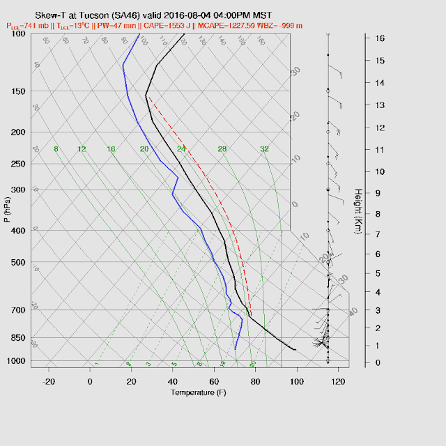
For the Tucson area, it looks like all the model runs are somewhat too warm due to the lack of clouds and shower activity. Saying that, there have been days recently where the atmosphere recovers rapidly. The forecast skewt-t diagram indicates over 1200 J/Kg CAPE, well-mixed PBL, and light and variable flow. This is probably a 'best case' and more likely the profile won't be so deeply mixed.
The model runs really disagree at Phoenix as the WRFGFS and NAM have around 1700 J/Kg of CAPE while the WRFRR has nearly 0!
 |
| WRFNAM |
Both the WRFGFS and NAM have scattered activity around both the Tucson and Phoenix area later this afternoon and into the evening. I feel the WRFGFS is overdoing it around Phoenix, but anything could happen if the CAPE is actually that high.
I'm running the 15Z WRFRR development version operationally now. It runs too late for me to have time to evaluate it. It has most activity restricted to SE and eastern Arizona this afternoon.
Day 2
Mid level flow becomes mainly southerly as a west coast trough moves to the east and the 500mb high is centered over west Texas. Mid level temperatures cool a degree or so over today.
Wet air remains over the eastern 1/2 of the state as a moderate southerly flow is present and continues to bring moisture in from Sonora.
As has been the case recently, CAPE remains moderate to high over eastern Arizona. The unknown will be how many clouds are present and how much heating will be restricted.
Storms are showing more organization and propagation tomorrow. Most activity is over the eastern 1/2 of the state including both eastern Pima, Pinal, and eastern Maricopa counties.


No comments:
Post a Comment
Note: Only a member of this blog may post a comment.