Saturday, August 20, 2022

20220820

 Previous Forecast

Wet and wild! The eastern 1/3 of the state received a widespread soaking, but only a few areas had flash flooding accumulations.  That was reserved for NM where there were large areas that received over 1".  A squall line again moved north to south over western Arizona all the way to Puerto Penasco.

Fortunately, some of the extreme forecasts from the WRFRR didn't verify.  A 15Z run had 6" accumulation for Mt Lemmon, but gauge data show "only" 2.8", which was close to one of the clusters of the ensemble forecast of 2.5".  All the runs forecast the western Arizona activity well.

Discussion

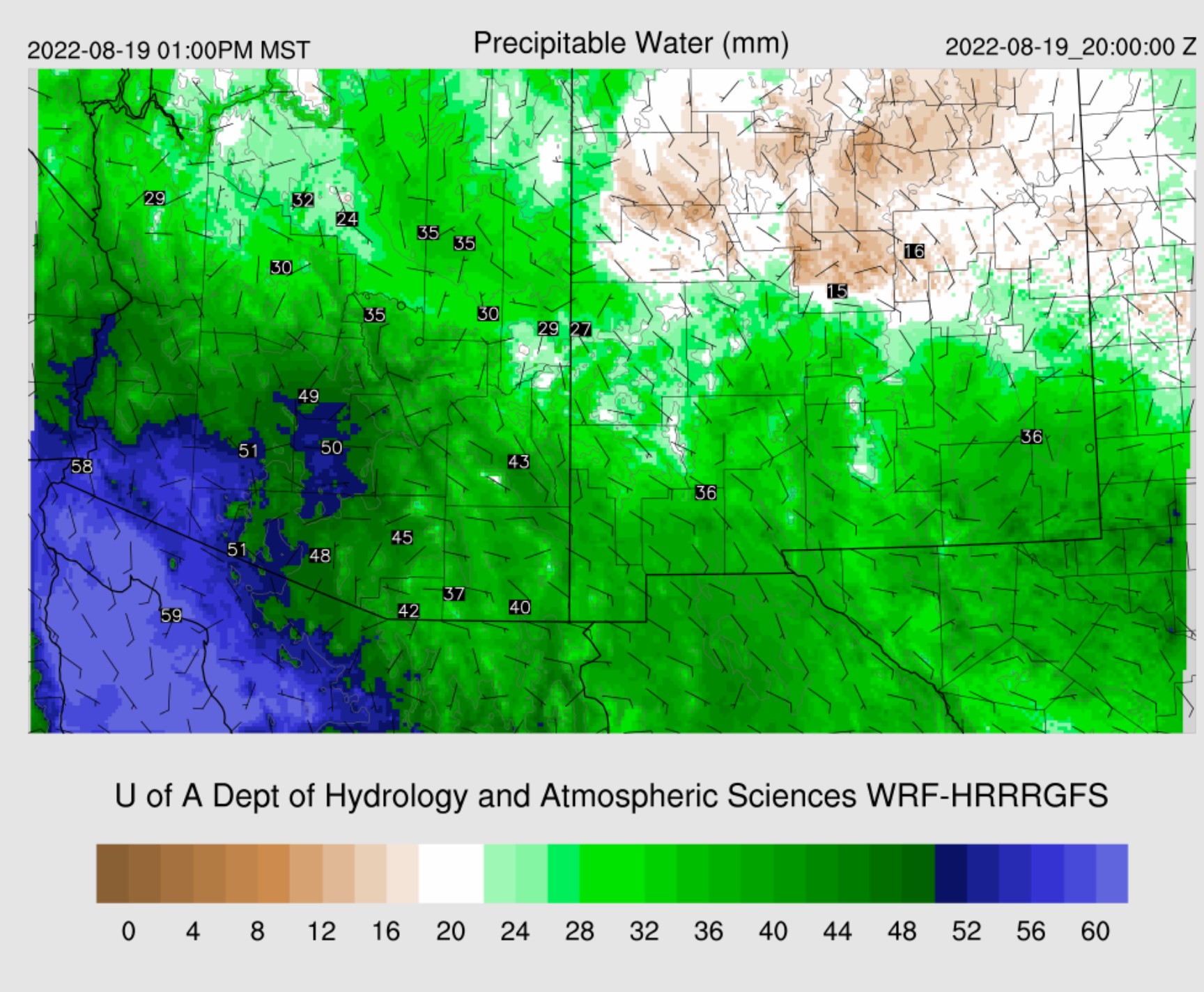
The remnant low-level cyclonic circulation appears to be near Sonora's west coast, not far from Hermosillo.  Convection has been firing for much of the night in the general area.  A drying trend has begun in western Arizona as PW has decreased to less than 50mm, but that may be temporary as it appears to be post squall line subsidence induced. PW is extremely high elsewhere.  For example, Tucson is at 2.02" and looking at the sounding climatology, these are some of the highest amounts ever recorded.  According to the GPSMET UofA sensor, PW peaked at 53.7mm overnight, which ties the all-time record from the sounding record.


The morning sounding is saturated all the way up, as would be expected.  The CAPE is a skinny tropical profile with almost 1000 J/kg of Mixed Layer CAPE.  Winds are poor, with southwesterlies dominating.  Low and mid-level winds appear to be temporarily affected by a possible MCV from the western Arizona squall line and will probably go back to southeasterly shortly.  Even a little sun should be sufficient to get heavy showers and a few storms going today.


It's about the same situation in Phoenix.   Like Tucson, Phoenix also has strong upper-level wiresence of the upper-level trough.

It is a complicated pattern at 250mb with a broad trough over the SW and another closed circulation in Utah.  Southern Arizona seems to be in a weak difluent pattern, which isn't as strong as was forecast by some of the runs from yesterday.  NM isresultingch resulted in all the rain there over the past 18 hours.

500mb is even more of a mess.  The UT closed low has -7 to -9C associated with it, bueems to be stuck and hasn't moved much since yesterday.  Who knows what is going on in Arizona and Sonora, especially as the Guaymas sounding is missing at 500mb.  However, data is present at 850mb, indicating the old TD might be going strong as there are 30-knot southerly winds!  25 knots at 925mb.  It's hy for sure if these winds are correct as there was deep convection near the sounding location.

Initializaevident
It's clear in far western Arizona, so GOES CAPE is working there, and it's very high, above 1000 J/kg.  For some reason, GOES-derived CAPE, at least here in the SW, always is less than sounding derived CAPE.   Clouds and showers were initialized well by all initializations.  The various RR runs had too much morning activity in SE Arizona.  The 6Z HRRR and GFS were much better.  The 12Z HRRR also had a bit too much.  A weak cyclonic circulation is visible in the  loop just north of Tucson and is responsible for the ongoing shower activity.  This circulation was generally initialized too far to the northeast, but the 12Z HRRR was better.  All were able to initialize the remnant low well.  I'm presently surprised by how well everything looks, considering the complexity.  The only major issue is with the RR series having too much morning activity, which may not even be a serious error.

Day 1
The GofC low drifts slowly to the north and begins to weaken.  It also has started to advect some dry air into the circulation from the Pacific, at least at 850mb.  Dewpoints are still 15 to 17C from central Arizona to New Mexico.

PW remains very high, with the wettest air shifting to the east.  Tucson remains around 50mm.

CAPE continues to be marginal for storms for much of southeastern and eastern Arizona but is moderate to high from Phoenix westward.  It looks like another western/central Arizona rimshot this evening.

Upper-level difluence/divergence is minimal and only over southeastern Arizona and into NM as the jet moves out.  However, a trough remains over California.  The UT closed low doesn't move much.

The UT low advects cooler air at 500mb into northern Arizona, which offsets the lack of upper-level support.

Heavy showers and maybe a few thunderstorms reform during the afternoon hours across southeastern Arizona.  Stronger storms develop near the Phoenix area and over northwestern Arizona by late afternoon.

It looks very favorable for big storms in and around Phoenix this evening.  Steering flow is excellent, from the NE at 20 knots, with some low-level shear and upper-level winds in the opposite direction of steering.  CAPE is high, at 1800 J/kg.

All model runs have another squall line-like feature moving across Phoenix and west this evening.


Some areas of severe winds are likely, mainly due to wet microbursts.  Frequent lightning and flash flooding are also likely.

Some runs have 2" or more of rainfall in and around Phoenix.  Some areas of southeastern Arizona also see excessive amounts of rain into tomorrow morning.

  
Day 2
The remnant low moves slowly north and is over the northern Gulf of California by morning.   This location results in continued southerly flow over a wide area of southeastern Arizona.

The mid-level circulation decouples and starts to move into far southern Arizona.

This low is responsible for continuing the heavy showers and maybe some thunder into the morning hours tomorrow.

Activity decreases for southeastern Arizona, but with daytime heating and some CAPE, another(!) squall line feature develops NW of Phoenix.  The lower deserts have finally been worked over enough as the storms die as they move towards Yuma.


Friday, August 19, 2022

20220819

 Previous Forecast

It was an active evening for Phoenix and much of southwestern Arizona.  There were some severe reports, plus flash flooding.


The WRFRR and somewhat surprising, as it's not been doing very well this summer, and the WRFGFS had the best forecasts.


Discussion
Something very unusual is going on over the central Gulf of California.  It looks like the old tropical system is trying to spin up again.  An obvious large low-level circulation centered over the Gulf and intense deep convection located over the center of the circulation.  Tropical systems can maintain themselves as they move up the Gulf, but I've never seen one regenerate!

The 500mb map is quite complex, with a cutoff low working its way across northern NV and a large but weak cyclonic circulation over Sonora.  500mb temperatures continue to be tropical, at -6 to -4C.

The 300mb map has a trough moving into western Arizona, supporting any storms that get going today, tonight, and tomorrow.  Due to the slow-moving trough, this will likely be a long-duration heavy rain event.

It is wet out there!  PW is about as high as it gets at Tucson, at nearly 50mm.  MLCAPE is very high, over 1400 J/kg.  Steering winds are pretty good, out of the east at 10 to 20 knots.  However, a notable inversion around 600mb may keep a lid on deep convection.  It won't take much to get things going, though, as the LFC is only 800mb.  Another issue is that on days like this, a little heating sets storms off early over nearby mountains and clouding over the valleys, so heating is cut off, and nothing happens in the lower elevations.  On the other hand, with the presence of the upper trough, there may be enough support for deep convection.  After saying all of the above, my guess is 1400 J/kg of CAPE will win out, and Tucson should be active.


Phoenix doesn't look as favorable as MLCAPE is only 800 J/kg.  Steering flow is also poor.

Initializations
Clouds, clouds, and more clouds.  Shockley, all initializations were accurate with their depiction of all the clouds.  They also had the weak morning showers initialized well.  Even the RR didn't have too much activity like it sometimes has.  They all had the low-level circulation accurately initialized, just south of Isla Tiberon.  Despite all the challenges, the initializations look good, and no clear favorite exists.

Day 1
The potential spinup or, at minimum, continuing the TD's circulation and its location will majorly impact Arizona's weather over the next few days.  The surge event has ceased, but historic amounts of PW remain over the state. 


850mb is especially interesting as the cyclonic circulation is well established, resulting in extreme amounts of moisture advecting into the state, especially the southeast and southcentral.  It's a rare event to see 18C dewpoints at 850.  

Despite all the moisture in SE Arizona, CAPE is still marginal but slightly better than the past few days.  It's much better from Tucson to Phoenix and westward. 

Despite all the clouds, by early afternoon, all runs are similar in developing scattered storms over much of the eastern 1/2 of the state.  Tall skinny CAPE profiles, weak steering, and a warm rain process will result in storms producing heavy rain.  Another round of mid-day flash flooding near Flagstaff.

Heavy showers and thunderstorms continue to expand to the west during the late afternoon hours while precipitation continues in eastern Arizona.

It appears east-central Arizona will receive a long period of heavy precipitation due to orographic enhanced upslope flow and southeasterly and eventually southerly flow across eastern Arizona and western NM.  This is in combination with the support of the upper trough.

As the upper-trough moves closer, divergence/difluence increases over southern Arizona and western NM.


Many runs consolidate the scattered storms north of Phoenix into a tropical squall line, which moves south during the evening hours.  Some have it moving into Phoenix, but others, just to the west.  As Phoenix got worked over last night, I'll go with the westernmost forecast.


The situation overnight for east-central and west-central NM becomes more serious as the flow becomes more southerly, thus already enhancing the orographic enhancement.

This isn't the only location at risk, as many runs continue storms and heavy rain over south-central Arizona into the early morning, forced by the upper trough.

24 hours accumulated precipitation, ending 5am tomorrow.


Day 2
All the runs maintain the low/mid-level cyclonic circulation, and some intensify it, like the WRFRR.  At 5am, the location hasn't changed much, but there is a broad area of 20-knot winds on the east side.  I've used the firehose analogy earlier this season, but this is more like a raging river!

The 250mb trough continues to provide some upper-level divergence/difluence, especially over southeastern Arizona into western NM. (5am forecast)

Heavy rain and thunderstorms continue to reform under this area of upper-level support.  The runs are slightly different with the location, as the WRFHRRR is a bit farther to the south than the WRFRR(below).

Things settle down by mid-day but ramp back up later in the afternoon.  Storms develop over southeastern Arizona, and another squall line-like feature forms and moves south towards central and western Arizona.

48-hour accumulated precipitation.  Insanity!


Thursday, August 18, 2022

20220818

 Previous Forecast

It was a wild night just west of Tucson as training strong to severe storms resulted in heavy rain with some areas over 4".  Gauge data indicated 2.17 at Three Points and 3.15 at highway 286/Altar wash.  Tucson mainly received light precipitation, and Phoenix wly quiet, despite a 0Z sounding with almost 1700 J/kg of MLCAPE.


Generally, most of the forecasts had the right idea of keeping Phoenix quiet while forecasting a significant precipitation event west of Tucson.  The 12Z WRFRR and 15Z WRFHRRR were the best.


Discussion

Visible satellite imagery indicates the remnant low is just south of Cochise County.  The 500mb map has a broad area of cyclonic circulation over NW Mexico, southeastern AZ, and SW NM, but temperatures are still a warm -6 to -4C.  A broad trough has amplified the 500mb ridge (or vice versa)  over the western CONUS.  There is a cutoff low near Reno, which may play a role in our weather in a few days. 


The PW insanity continues!  It's 56mm at Yuma, 52mm at Phoenix, and 45mm at on.  Unfortunately, most of the Arizona GPSMET IPW data has been missing for a few days now.  The Phoenix sounding is saturated all the way up, and there is almost 700 J/kg of MLCAPE, which isn't too bad.  Mid and lower troposphere winds are northeasterly, so perhaps higher elevation storms will be steered into the valley at some point today/tonight.

Tucson is mostly the same, but a couple of inversions may make deep convection difficult, plus CAPE is marginal at 469 J/kg.

Initializations
It is not as cloudy as it could be, considering the amounts of moisture around.  Cloud initializations are mostly accurate, but the 12Z RR clouds are too thick and widespread, especially in western Arizona.  The initial position,, of the low is generally accurate.  Most runs should perform well, except for the 12Z WRFRR which will probably have issues in central and western Arizona.  

Day 1
The firehose/Gulf Surge continues into the afternoon, keeping PW at extreme levels.  The low-level easterly flow will weaken somewhat but still may keep convection to a minimum east of Tucson, especially considering all the clouds present.

850mb is interesting as it appears the old TD low-level circulation is centered over Nogales.  Dewpoint temperatures continue to be high at 15 to 16C.

CAPE continues to be marginaof the eastern 1/3 of the state.  250mb indicates a little divergence/difluence is present over SE Arizona, but who knows if it will be sufficient to force anything more than brief heavy showers.  CAPE is much more favorable in central and western Arizona, which is high to extreme.  However, western Arizona is strongly capped, as seen on the 14Z Yuma sounding.  MUCAPE is 2755 J/kg, so the below forecast of  2-3000 J/kg seems reasonable.


It takes some time to get storms going; by late afternoon, much of southern and southeastern Arizona is still quiet.  All the runs are nearly identical to this forecast.

While Tucson has a fair amount of CAPE, around 1000 J/kg, there appears to be a bit of dry air entrainment just above the mixed layer and a weak inversion.  The vertical wind profile has no low-level shear, but steering flow is quite strong from the ENE.  Another subsidence inversion is present just above 500mb.  All these things seem to be conspiring against any deep convection.


During the evening, activity starts to pick up around the Phoenix area as steering flow is favorable for moving the existing storms into the valley.  Every run has activity n or nar Phoenix, so something will likely happen there.  The 12ZHRRR, below, is the least active of all the runs.


The forecast Skew-T looks pretty good, with over 1500 J/kg, some low-level shear, 10 knots of easterly steering flow, anvil-level winds from the opposite direction, and a deeply mixed PBL.  There is a cap, but with some outflow interactions, this cap can be broken.

Many runs develop widespread strong to severe storms for southwestern Arizona late this evening.  It's not often I talk about Yuma, but the forecast Skew-T indicates this is a real possability as the cap weakens by early evening.  CAPE is extremely high, nearly 3000 J/kg, and PW is 56mm.  Storms that manage to break the cap will be severe and produce extreme rainfall.

The most conservative run (like Phoenix) is the 12Z WRFHRRR, and it has storms for parts of SW Arisignificantlater this evening.

The 9Z WRFRR (and 6Z WRFHRR/GFS) forecasts a major severe weather and flash flooding event.  We'll see later this morning if the 15Z WRFRR and/or the WRFHRRR confirm this forecast.

Some runs have areas of 4-6" of rain in SW Arizona.

Day 2
There is no reason to try to forecast any details for tomorrow.  The general outlook is we remain in the soup, with PW again from 50 to 58mm over the southwestern deserts.  SE low-level flow continues over southeastern Arizona, which will probably continue to suppress activity there.

CAPE is forecast to be a bit higher for eastern and southeastern Arizona, so there may be more activity after all.  With steering still being easterly, perhaps the Tucson and Phoenix areas will see more activity as there will be more upstream storms.  CAPE would certainly support big storms for Pima and Pinal Counties.