Precipitation was limited to mainly the high terrain of northern and eastern Arizona. Quite a bit fell over far eastern Arizona as showers and storms were present for a long period.

Discussion
The 500mb pattern is about the same as yesterday except for one important change. A pronounced mid-level cyclonic circulation is over far southeastern Arizona and is responsible for the ongoing showers and clouds. Some cooler air at 500mb is also present as temperatures have decreased to -7 to -9C.

PW has generally increased as the surge that was mentioned yesterday is now underway as Yuma has southerly winds and a surface dew-point of 70F. The surge seems mainly triggered by the outflow from the widespread storm activity in Sonora last night. The increase in moisture and slight cooling has not helped the CAPE situation that much. The morning sounding says only 200 J/kg of MLCAPE. Phoenix has around 100 J/kg. The mid-level steering flow is still not very good as it is quite weak at only 10 knots. However, it is from the NNE thus storms that form over the higher terrain could move into the lower elevations. Maybe they will improve throughout the day.
Initializations
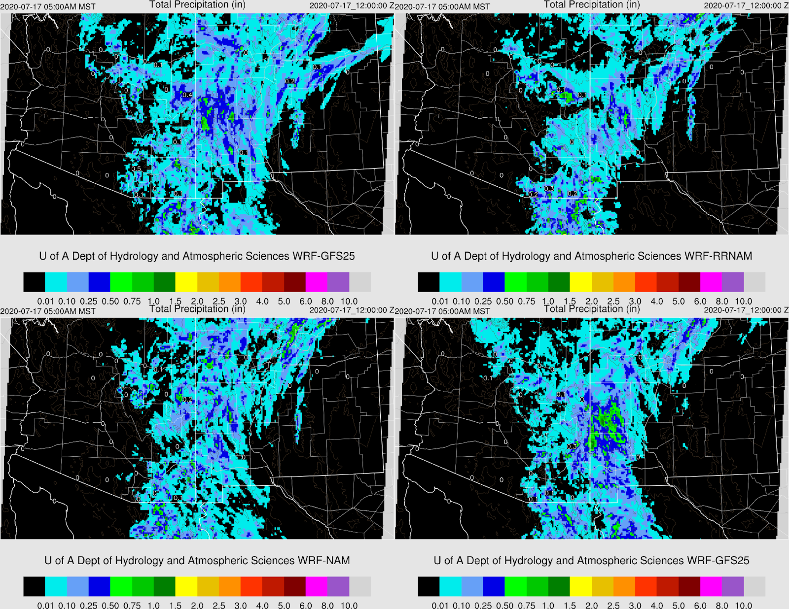
It's going to be a challenge to get the initial conditions accurate with such a complex situation. Widespread clouds and some showers continue this morning over much of eastern Arizona. In years past, this sort of situation would result in poor forecasts as clouds were usually not initialized well. However, due to improvements in the way WRF handles clouds this year plus generally better initializations from NCEP, all four of the morning runs have the clouds initialized well.


The initializations have the mid-level anticyclone initialized accurately and this is a good thing as it's likely to play a significant roll in our weather today. The 6 and 12Z NAM has some moderate PW errors over both northern Mexico and Arizona, where it is too moist. It looks like the WRFGFS and RR have the best initializations today.
Day 1
The moisture surge has resulted in increased moisture over much of central Arizona resulting in favorable 850mb dew-points of 10C or greater.

CAPE has also increased over much of southern and southwestern Arizona. Central Pima County looks especially primed for a major convective event as CAPE is very high and skies are now mostly clear. West of there, model Skew-T forecasts indicate the atmosphere is strongly capped.

By early afternoon, strong storms develop over the high terrain of eastern Arizona in advance of the mid-level circulation. It's still very cloudy in this area so I have my doubts. Storms also form over the high terrain of eastern and central Pima County.

Steering flow over Gila and southern Apache appears favorable for steering storms off the high terrain into the lower elevations of Pinal. Add in the support from the low and it should be an active day for much of eastern and central Arizona.

Coverage and intensity increase during the afternoon hours. Very strong/severe storms are possible for central Pima County. There is a big spread for amount of activity from the various model runs. The WRFNAM is even more active while the WRFGFS is less, especially for Gila/Pinal. The WRFRR is in the middle.

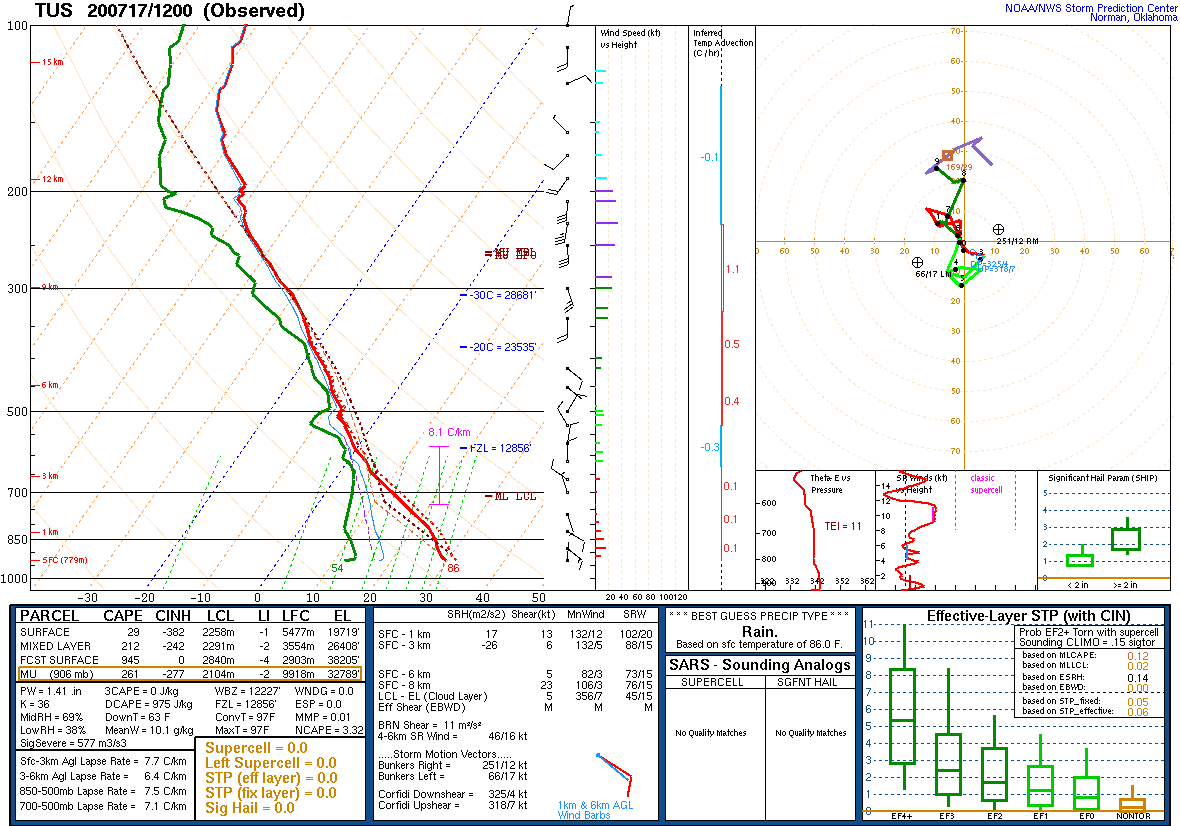
The forecast Skew-T for Tucson has a fair amount of CAPE and a deep mixed layer, which is good news. I don't know what to make of the wind profile as it's all over the place. Mid-level steering flow is 15-20 knots from the NW due to the location of the low which I would think isn't very good. Also, some layers of the upper winds are southerly which may result in anvils blowing over the Tucson area, which is bad so it's a mixed bag.

It's the first decent CAPE day of the monsoon for Phoenix. The mixed layer isn't that deep and CAPE isn't great so probably no storms for Phoenix, but at least there is a chance. The wind profile looks good though so I bet storms from the NE get close.

By late afternoon, storms die as they move into the lower elevations. It looks like not enough CAPE and/or too strong of a cap at the top of the mixed layer. Maybe a dust storm for Phoenix as the outflow moves in from the east?

Day 2
The cyclonic circulation washes out into just an ill-defined inverted trough over eastern Arizona. A new center of the 500mb anticyclone sets up over Vegas which results in favorable NE steering flow over northern and central Arizona. Unfavorably warm air is present over southeastern Arizona.

Weak moisture advection from the Gulf of California keeps PW fairly high.

In spite of the moisture, CAPE is quite low over most of the state. Is the monsoon ever going to kick it into high gear!?!?

This is it????

The westerlies are back, at least above 500mb.

No comments:
Post a Comment
Note: Only a member of this blog may post a comment.