Moisture has moved back into southeastern Arizona due to outflows from all the activity in northeastern Sonora and northwestern Chihuahua last night. PW has increased to 32-35mm, and surface dew-points are in the mid to upper 50's.
The center of the 500mb anti-cyclone has moved to northern Texas, but the flow is mostly light and variable, which unfavorable for storm movement. Temperatures have cooled slightly to around -6 to -7C, thus somewhat less hostile form storms.
The morning Tucson sounding has a bit of CAPE present and only weak inversions, but winds are light and variable below 300mb. Nevertheless, this is one of the better-looking Skew-T's so far this season.
Initializations
Morning satellite imagery indicates that there is an MCV from all that Mexico activity, in far SW NM, moving north. There are some debris clouds over southeastern Arizona, but they are dissipating. 6Z and 12Z runs initialized both the clouds and the MCV well, which is somewhat of a surprise. The 6Z NAM had some moderate wet errors with PW in Mexico, but other than that, the initializations look good with no clear favorite.
Many of the Suominet GPSIPW stations south of Hermosillo are no longer reporting for unknown reasons. My guess is there are no funds to maintain and troubleshoot them, similar to what I've seen here in the US. On the other hand, upper air stations have been reporting consistently, at both 0 and 12Z. However, Chihuahua has had a 20-30m or so, low bias at 500mb.
Day 1
The focus will be on the moisture boundary over SE Arizona and how it moves throughout the day. The morning 850mb shows this line very clearly, with Tucson being right on the edge. Flow to the west of Tucson is still mainly southwesterly and dry. The rest of SE Arizona is quite wet with a favorable 850mb Td of >=10C, so just based on that, it should be an active afternoon and evening at those locations.
Low to moderate CAPE is forecast over southeastern Arizona for this afternoon and is sufficient to support deep convection. Tucson is right on the boundary of this unstable air.
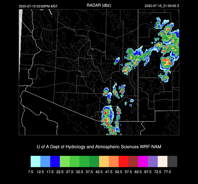
The WRFNAM is a bit wetter and more unstable at Tucson as PW is 33mm, and CAPE is around 500 J/kg by early afternoon. Mid-level steering flow is weak at only 5-10 knots from the southeast.
As would be expected, the models forecast scattered storms to develop in areas that have the most CAPE. Some storms are quite strong and are likely to produce strong to isolated severe winds as the morning DCAPE on the Tucson upper air data was 1600 J/kg.
The WRFRR develops storms a bit later in the afternoon.
Storms may continue into the evening hours over far southeastern Arizona as an MCS moves in from Mexico.
Day 2
The wet/dry line moves to the west and is almost to Phoenix by mid-day. 850mb dew-points are sufficient for storm activity to the east of this line.
CAPE isn't all that impressive but is sufficient to support scattered storms.
What is impressive are the mid-level steering winds as they are southeasterly at 15-20 knots; thus storms that form over the high terrain will be steered into the lower elevations. Tucson has sufficient CAPE to support some storms in the area later tomorrow afternoon. Strong to isolated severe microburst winds will be the primary issue as there is a significant inverted V profile.
The various model runs are similar in that they develop strong/severe storms over the higher terrain of eastern and central Pima county by late afternoon. Favorable steering should move these storms into the lower elevations.
The models differ on how far the storms make it into Pinal county, but it does look likely that a haboob will impact that area later in the day.
Storms continue over SE Arizona into the evening as it appears that an inverted trough/MCS moves into the area, keeping the storms going well into the evening.


No comments:
Post a Comment
Note: Only a member of this blog may post a comment.