Previous Forecast
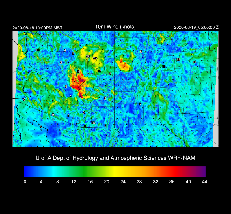
Model performance was again quite good, especially by the WRFNAM and WRFGFS. It was interesting to see that the morning runs of the HRRR did not predict a strong outflow boundary for Phoenix while the WRFGFS and NAM intensity was higher and covered a larger area.
The 15Z HRRR was the only morning run to come close.
Discussion
You don't see a map like this very often, that is for sure. A close 600dm contour and two stations reporting 600dm heights. 500mb winds continue to intensify over Arizona with upper-air stations reporting 30-40 knots. You don't see that too often either. Temperatures continue to run fairly cool at -7 to -8C, resulting in steep lapse rates as the surface is so hot.
This strong easterly flow goes all the way to the surface and is advecting dry air from NM over much of eastern and northern Arizona. A tongue of 1"+ moist air is over the Phoenix area and to the west which might support some activity in that area later today and tonight. I was curious how well the Suominet sites compared to the GOES derived PW product and for the few stations I looked at, it was extremely close. The only issue with GOES PW is that when it gets cloudy, you have no data so I still think it's important to try and keep Suominet alive.
CAPE is quite high in western Arizona, but not at Phoenix. The Skew-T looked much like this yesterday, and resulted in some activity anyways.
Initializations
It's a straightforward situation this morning so model initial conditions are generally good. The 6Z NAM and GFS had a large moist bias over in NM with a lot of 5-10mm errors so I'm a little worried the WRF might be too active. 12Z RR and NAM initialized PW well.
Day 1
Unfavorable easterly downslope flow continues over much of eastern and now, central Arizona. Moist air continues to be over the Colorado River valley, which may support activity later today and tonight.
CAPE is low to moderate over the high terrain of the Rim and White Mountains, in spite of the relatively dry airmass. Showers and storms are likely there today. Out west, CAPE is more than enough for strong storms.
Scattered showers and weak storms manage to form by later in the afternoon over the high terrain.
Storms move into the Colorado River valley in NW Arizona and also move to the southwest from the higher terrain of NE Arizona/NW NM. When steering flow is favorable, storms that initiate here can sometimes make it all the way to the lower elevations of central/southcentral Arizona later in the evening.
Is that going to happen tonight? Some of the WRF forecasts think so. The CAPE forecast by the 12Z WRFNAM might have enough CAPE to support these storms enough to get close. Also, it appears a surge gets underway in southwestern Arizona. Hopefully, this is the beginning of the return of significant moisture and CAPE to Arizona.
It's a big "maybe" for late-night activity. CAPE only 150-500 J/kg, but the boundary layer is still mixed deeply and there is no inversion at the top of the mixed layer. It wouldn't take much to kick off some weak activity. The inverted V profile is enormous so very strong winds would again be likely.
Another strong to isolated severe outflow boundary approaches eastern Maricopa and Pinal Counties later this evening.
A bunch of the model runs are predicting these storms to make it to the lower elevations of central Arizona later tonight. As CAPE is limited, they will probably be mostly wind and only limited precipitation.
Day 2
The low-level easterlies finally decrease and allow moisture to slosh back to the east somewhat and reducing the afternoon drying from downslope winds over southeastern Arizona.
CAPE generally increases, especially over the higher terrain.
However, with this somewhat moister, cooler, and CAPE, comes a stronger inversion on top of the mixed layer which keeps storms from forming over lower elevations.
Storms remain mostly over the higher terrain.


No comments:
Post a Comment
Note: Only a member of this blog may post a comment.