The activity was mainly restricted to Cochise and Santa Cruz Counties. A storm developed over the Catalinas in the late afternoon and managed to drop a little rain across eastern Tucson. The New Mexico storms were not as widespread as forecast nor as severe, but some wind gusts of >50mph were reported.

All runs performed well in New Mexico, but the WRFRR did not do well in Arizona as it was too light.


Discussion
The 500mb anticyclone is centered over Arizona with mainly light and variable winds except for eastern Arizona, where Tucson has 20 knots from the northeast. Temperatures are relatively cool (compared to recent times) of around -7 to -8C. The 300mb plot has a substantial area of upper-level divergence over SW NM and far SE AZ, which may help support deep convection, assuming there is any CAPE.


A strong Gulf Surge is underway with 15-20 knot winds at Yuma and dewpoints in the low 70's. The surge has made it almost to Phoenix as winds are southerly, and dewpoints are in the upper 60's south of the airport. Surface winds are generally easterly over southeastern Arizona with dewpoints in the low 50's. It has dried out in SW New Mexico, and this dry air is being advected into southeastern Arizona, which may put a big damper on all the deep convection that was being forecast for this area, yesterday.

The Phoenix upper-air data shows this moisture increase, which results in quite a bit of MLCAPE of almost 1400 J/kg. The lower atmosphere has been cooled, and there is now a cap around 800mb. There is a substantial subsidence inversion at 400mb too.
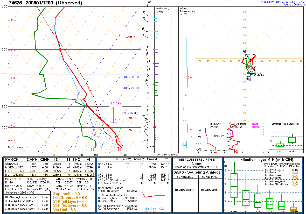
Tucson has quite a bit of moisture in the layer below the nasty 400mb inversion, but CAPE is only 200 J/kg. In fact, the MU layer isn't anywhere near the surface, but at around 700mb. There has been some high based in the vicinity this morning. Near-surface winds were strong out of the southwest, so maybe that is the beginning of the surge?

Initializations
The bad news is the UCAR Suominet GPSIPW system is completely down as of about 21Z yesterday. I've emailed them, but there will be no action taken until at least Monday. Thus, we are without this vital tool for both real-time monitoring of PW and model error identification and correction. This network is so important, and I just don't understand why there isn't more of an effort by the forecast community to make it operational. It's run on a minimal budget and considered experimental, so not guaranteed to be available. In fact, it is sometimes down for extended periods.
It's mainly clear over Arizona, with only a few areas of dissipating clouds and showers over southeastern Arizona. No cyclonic circulations were noted in either the upper-air data or the satellite imagery. Model initializations are generally good except the 6Z GFS is too cloudy over central Arizona. The exception is the 12Z NAM as it couldn't even initialize PW correctly at Phoenix, which has sounding data! It initialized 37mm, whereas the observed PW was 34mm. Another exception is the 15Z RR as it has Tucson way too dry, at 27mm. The 14Z RR development version was also run, and it had IP initialized well at Tucson and Phoenix.
Day 1
While moisture has increased over southcentral and central Arizona, it's decreased in far southeastern Arizona as the strong outflow that was predicted into that part of the state, did not materialize. By mid-day, westerly flow is advecting moisture back into that area, but will it be enough and in time to support the widespread severe activity that was forecast yesterday?

CAPE does increase throughout the day but is still low to moderate over far southeastern Arizona. It is moderate to very high over the rest of the southern 1/2 of the state, much like the model forecasts from yesterday.

While CAPE is around 2000 J/kg at Tucson this afternoon, the mixed layer is very shallow for this time of day, and there is a bit of an inversion on top of the mixed layer. It's going to take a lot of lifting and mixing to get any deep convection here. The wind profile is good with low-level shear, easterly to northeasterly steering and upper winds blowing anvils away from the storm motion.

It looks a bit better for the higher terrain of SE Arizona as Nogales is mixed deeper, and the inversion is weaker, compared to areas to the north and west. So, there is some hope for this narrow band where CAPE is high, and the PBL is deeply mixed.

The general model consensus is that storms develop over the higher terrain of eastern Arizona and move to the SSW. Other runs develop near or just south of the Arizona/Sonora border.

The storms that are moving down from the north run into the low CAPE air and weaken, but may be able to generate strong enough outflows to trigger storms in the higher CAPE air to the south and west.

It looks like the only locations that will experience strong to severe storms is right along the border.

There is a slight chance that some early morning storms could form over southeastern Arizona. The WRFNAM really goes crazy, but as it is most likely too wet, so I discount it. However, the 12Z WRFGFS also develops some storms, and it's certainly possible with all this CAPE.

Day 2
Despite a continued weak southerly flow from the Gulf of California, moisture mostly decreases.

CAPE is still quite high over southern Arizona and increases over southeastern Arizona compared to today. I'm assuming that most lower elevation areas have a high amount of convective inhibition due to a cap, so it will be the mid and higher elevations that see the most activity.

Another major problem is the dry air advection above the moist layer. The 700mb plot shows that clearly. Certainly not a typical 700mb monsoon pattern!

There is a wide spread in the model forecasts tomorrow from only a few storms over far eastern Arizona to quite a bit of activity from Tucson eastward. The WRFRR is quite over far SE Arizona during the afternoon hours.

Again, the strongest storms are along the border with Mexico.

The WRFRR is an outlier as it develops a few evening storms in Pima County tomorrow evening.

No comments:
Post a Comment
Note: Only a member of this blog may post a comment.