Discussion
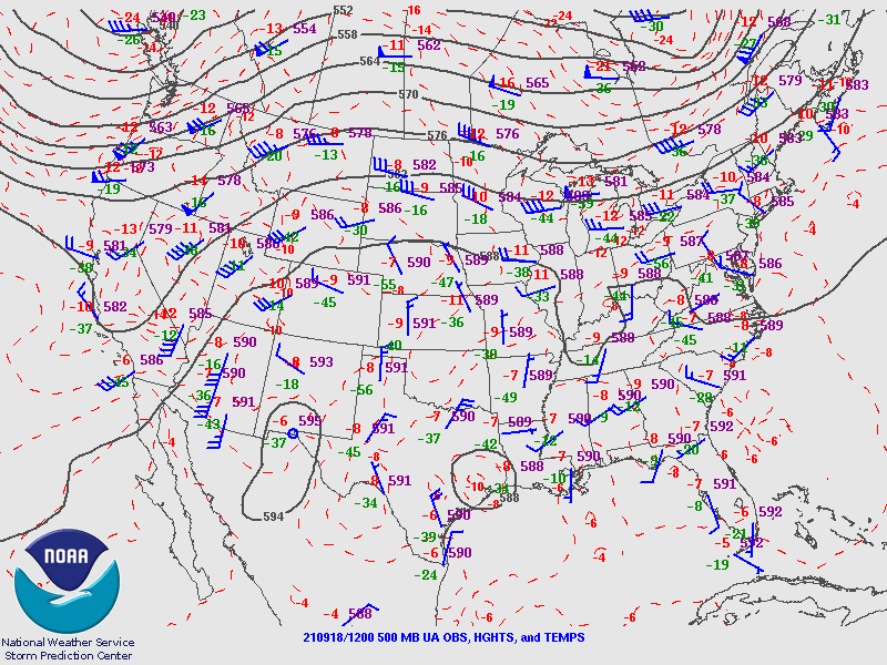
A western CONUS trough has finally pushed the 500mb anticyclone center to the east of Arizona, resulting in quite a strong southerly flow. Temperatures have decreased to -6 to -8C.
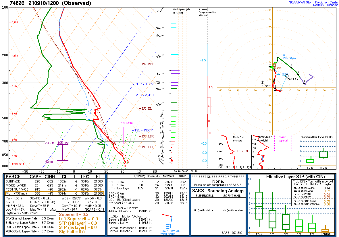
The 12Z soundings from Phoenix and Tucson are unimpressive, even sad. While moisture has slowly increased over the state, there is still limited CAPE available. Worse, there is a mountain of an inversion to overcome above 500mb. Why the model runs are going crazy with convection later today is a mystery to me, at least so far.

There has been quite a bit of trouble over the past two days as there were problems with missing initialization files from NCEP. Those were solved last night, so most runs succeeded. As mentioned recently, the NAM is slowly being phased and replaced by a mix of the RR and HRRR. This morning, clouds are scattered about the state, making for a bit of a challenge for the initializations. Also, GOES-derived CAPE is present over parts of southwestern Arizona, so that is a positive development. The RR and HRRR do not have any clouds over far western NM but are OK elsewhere, including the far NW Arizona convection. The 6z GFS did have thick clouds in far eastern Arizona, which isn't correct either as clouds are further east and not as thick. The WRFGFS also had scattered showers over eastern Arizona this morning, in error. CAPE was initialized accurately by all. There is no clear favorite, and the errors don't seem significant enough to impact accuracy.

Day 1
Something has to change for storms to form today as moisture and CAPE are lacking, and the strong inversion above 500mb isn't going to allow much activity. A band of high 850mb dewpoints is present this afternoon over central and western Arizona. Typically, this would be enough to support widespread deep convection, especially over the higher terrain.

Moderate CAPE is associated with the area of high moisture.

Now the important bits-the model forecast Skew-T plots. This afternoon it's not looking very favorable for deep convection at Tucson despite moisture increasing to nearly 40mm. The inversion above 500mb is very strong. Another big question with the forecast is the increase of moisture to almost 40mm in Tucson. It's only 32mm now, so it has a long way to go to make it to 40mm, which is probably the minimum needed for deep convection.

The story is better at Phoenix as the inversion is weaker as the mid/upper trough moves closer to Arizona. This results in quite a bit more CAPE.

The OLR plot is interesting as it has widespread shallow convection below the inversion with scattered areas where the inversion is overcome, resulting in deep convection.

Most of the WRF runs forecast storms in and around the Tucson area by late afternoon despite the marginal-looking Tucson Skew-T. Again, I have my doubts that moisture can increase by another ~8mm by this afternoon.

Phoenix is looking good by late afternoon as the PBL is mixed well, and CAPE is around 1000-1500 J/kg. The inversion also weakens.

Most runs develop strong storms in and around the Phoenix area tonight.

The 4-panel plot shows precipitation for both Tucson and Phoenix is likely. As the increase in moisture at Tucson to 40mm looks unlikely, the less active runs are most likely.

Day 2
Much warmer air is advected into the state behind the departing trough. This is likely to shut down any deep convection, except for the far southeastern part of the state.


No comments:
Post a Comment
Note: Only a member of this blog may post a comment.