Previous Forecast
Another in a string of down days. The only activity was in far southeastern Arizona.
Again, the WRFRR runs did not predict enough precipitation. The WRFNAM and WRFGFS were far better.
Discussion
The Gulf Surge that was scheduled to begin, has done so as moisture and CAPE have increased over much of southwestern and southcentral Arizona.
Tucson's 12Z sounding has ~1500 J/kg of MUCAPE, located at 850mb. The wind profile is also good with low-level NW flow for inflow/shear, mid-level easterlies for steering, and upper-level westerlies to advect the anvils away from the storm motion. The only issue is that the NW flow above 850 to 70mb is quite dry. Perhaps with low-level moisture advection, the CBL will be able to overcome this hostile layer.
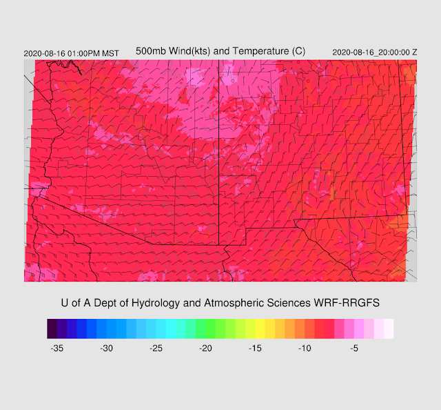
The NW CONUS trough has finally moved away, which allows the center of the anticyclone to move northward somewhat, placing southern Arizona in easterly flow. 500mb temperatures have also cooled slightly over NM and southern Arizona to a less hostile -7C.
Initializations
It's mostly clear over all of Arizona this morning and all initializations are the same. PW initializations were mainly small except the 12Z NAM was too wet in NW Mexico which may lead to too much activity later today and tomorrow. The 6Z NAM was better.
Day 1
The question for today is how far and fast the high CAPE airmass makes it into eastern and southeastern Arizona as the forecasts for yesterday had this area as the hotspot for storms. By early afternoon, the WRF continues with moist advection for much of southern Arizona and into far southeastern Arizona so enough moisture makes it there in time. Far southern Arizona has excellent 850mb dewpoints of around 13C.
Combined with slightly cooler mid-level temperatures, this moisture results in some moderate to extreme CAPE. CAPE is low over the high terrain of eastern AZ and western NM but should be enough to initiate storms which will then move towards the higher CAPE air over SE and SC Arizona.
The situation looks similar to back on August 1st. Storms or their outflow boundaries, move into southeastern Arizona by early evening, triggering stronger storms.
The Nogales forecast Skew-T certainly looks like it's ready to go by then with a deeply mixed CBL, >1000 J/kg of CAPE, and no real inversion at the top of the mixed layer. The wind profile looks excellent.
Strong to maybe severe storms expand and move to the SW over Cochise and into Santa Cruz counties this evening.
Even the mild-mannered WRFRR has strong/severe storms this evening.
What about Tucson? The wind profile is excellent and a moderate amount of CAPE is present. However, the CBL isn't mixed deep enough and there is a weak inversion on top of the mixed layer. Storms could happen if a strong outflow moves through, but the keyword is strong as the LFC is around 600mb.
A fairly strong outflow does move into eastern Pima County by later in the evening as winds are forecast to be 30 knots or so. The possibility for the development of deep convection is there, but none of the runs develop more than a few weak storms.
Day 2
All ingredients are there for a textbook tropical squall line/rimshot severe weather event for parts of southeastern and southcentral Arizona. By early afternoon, the battle line is drawn between the moist air over central Arizona and the beginning of the drying trend from the east in NM. These backdoor drylines frequently provide low-level convergence, focusing thunderstorm development.
The dryline is clearly defined on the CAPE plot too. CAPE is moderate to high just to the west of this line. Little or no activity is expected to the east. However, we'll have to wait and see until tomorrow to see exactly where the boundary sets up and today's runs have quite a bit of variance.
The 500mb pattern is good with ENE steering and moderately favorable -7C air over southern Arizona.
During the afternoon, scattered strong storms develop over the White Mountains of eastern Arizona and move to the southwest.
Well, hello there! Textbook severe Skew-T for Tucson. Deeply mixed, no inversions, deep sub-cloud layer/inverted V, and 15-20 knot ENE mid-level flow. The only minor issue is that westerly flow aloft would be better at keeping anvils away from the storm motion, but northerly isn't too bad. PW is pretty high so precipitation rates will be high, but fairly quick storm motion will reduce flash flooding risk somewhat.
Strong to severe storms move into eastern Pinal and Pima Counties by late afternoon or early evening.
It's likely that there will be a few areas with severe winds. Forecast wind speeds are as high at 50 knots, thus gusts over 70 knots are possible.
An organized area of strong to severe storms continues to move to the southwest during the evening hours. A strong outflow boundary moves into western Pinal County which will result in a large dust storm/haboob.
It looks like just a dust storm for Phoenix. The CBL is not mixed deeply at all and CAPE is marginal. There might be a few storms that manage to develop over the higher terrain near Phoenix though.


No comments:
Post a Comment
Note: Only a member of this blog may post a comment.