Previous Forecast
To say it was an active past 24 hours is an understatement. Widespread storms occurred during the afternoon and evening at Tucson and Phoenix and scattered over northern Arizona. An MCS got wound up over central Arizona overnight, resulting in more rain and storms. However, only a few severe reports were noted. Lightning and heavy rain were the main features of the storms. Tucson had an enormous amount of lighting with a late-night storm.
The WRFRR and WRFGFS were fairly accurate. One problem was the lack of evening activity in the Phoenix area, as many runs backed off on their previous forecast of an active evening. However, a few managed to develop storms: the 6Z WRFGFS and NAM. It appears WRF is doing a good job with the amounts of precipitation as it has resolved some of the heaviest rain amounts.
Discussion
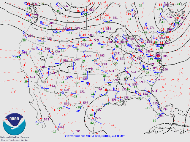
The MCS continues over central Arizona continues to generate scattered deep convection and widespread rain. Radar indicates that the area is weakening and slowly moving south. The IT is located over SW NM, which is about where it was forecast to be. It also has ongoing deep convection. The 500mb map still looks about the same, with the anticyclone centered somewhere near the Four Corners. The IT in NM has cool air associated with is at temperatures are around -9C. The MCS is also apparent.
The 300mb map indicates that much of Arizona is under strong divergence aloft, thanks to the NM IT.

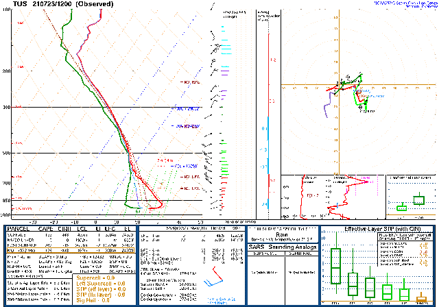
The Tucson and Phoenix soundings are the definitions of "worked over". Despite limited or no CAPE, storms are continuing north of Phoenix and west of Tucson! Both have an unusual wind profile, thanks to the MCV. Tucson has WNW winds all the way to 500mb. Once the MCV moves out, it will be difficult, if not impossible, for deep convection in the lower elevations today/tonight. Perhaps if there can be some heating, there might be some recovery.
Initializations
The NCEP initializations have their work cut out for them as they have to try and initialize a complex situation.
The 6Z NAM had a better representation of the clouds and the location of the MCV compared to the 6Z GFS, which wasn't much good for either. The 9Z RR was good except for too thick clouds over far eastern Arizona. The 12Z RR was also accurate, except the center of the MCS might be a little too far east. Its clouds and rain, and even storms on the periphery of the MCS, were initialized well. However, it appears that it has way too much moisture around the Phoenix area. The 12Z NAM? It had too much activity along I-40 near Winslow and deep convection near the center of the MCS. However, the clouds were initialized well, and PW errors weren't as large as usual. The 6Z WRFRR is the favored run today.
Day 1
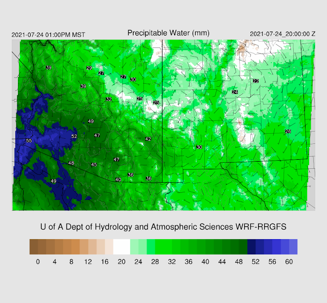
IMO, the 9Z WRFRR has a better handle on the moisture as the 12Z had 56mm at Phoenix, which appears way too high. It's impossible to say for sure as there are no operational GPSMET PW sensors in the Phoenix area. The 9Z is more reasonable at around 50mm. The firehose of moisture continues to flow into Arizona as the Surge continues.
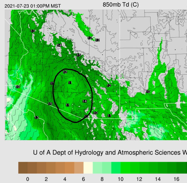
850mb continues to show that the Surge is deep, at least to 850. Drier air is present over south-central Arizona in the wake of the MCS, but other areas are in the 12 to 15C range.
The CAPE forecast looks reasonable as little or no CAPE is present over south-central Arizona. Another active day is on tap for the high country as CAPE is very high there.
Upper-level divergence/difluence continues over much of the state this afternoon and evening. Organized storms are again likely to form in NW New Mexico and NE Arizona and again move towards the lower elevations of south-central Arizona. (250mb 21Z)
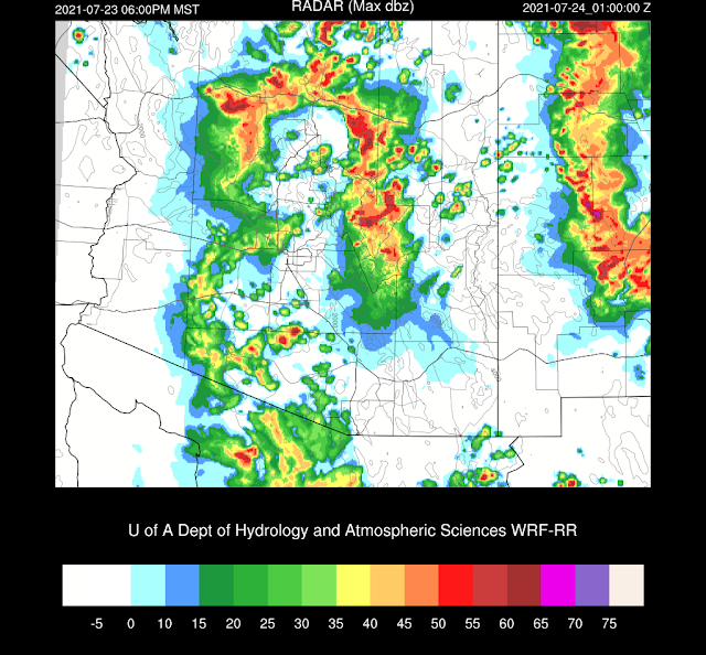
Clusters of strong to severe storms develop during the afternoon over the higher terrain of northern/eastern Arizona. Showers and a few weak storms continue to be associated with the decaying MCS, which is moving into Mexico. Model/forecast confidence is low as it appears only the 9Z WRFRR has a good handle on the situation, and it's uncomfortable to rely on just one model run.
By early evening, strong storms continue across much of the higher terrain of northern and eastern Arizona. Another organized line of storms is moving across NW NM towards Arizona.
Some of these storms produce excessive rainfall, over 3 inches in some locations.
Tucson and Phoenix struggle to recover, but they both have a bit of CAPE by late afternoon, which may be enough to support any activity that moves into the lower elevations. Note that the Skew-T plotting program did a poor job at determining surface-based CAPE. It should be higher, similar to Max CAPE. The wind profile continues to support moving higher elevations storms into south-central Arizona. The deep surge also continues.
As the morning has gone on, storms are continuing to redevelop to the northeast of Phoenix. This was not depicted by the 6Z WRFRR, which gives me little confidence in the above forecast. The 15Z RR (now available) has a bit more activity and moves it into Phoenix around mid-day.
Generally, southern Arizona gets a respite from the heavy precipitation, but areas north of Phoenix are at high risk of receiving another 1/2 to over 3".
Day 2
The NM inverted trough drifts westward and is over southeastern Arizona by early afternoon, resulting in continued northeasterly steering flow.
Support continues at upper levels as divergence/difluence continues over the state.
The Surge weakens, but that doesn't matter as there is a lot of moisture over the whole state, so the flash flooding risk continues.
CAPE is limited for much of the lower elevations but may be sufficient to still support some deep convection. It appears that more widespread activity will be limited for northern Arizona.
Forecast confidence is very low due to the extremely complex synoptic and mesoscale situation and the uncertainty with today's forecast. It appears that southern Arizona will have scattered rain and thunderstorms during the morning hours.
Scattered strong to severe storms are likely to be over parts of northern and eastern Arizona by late afternoon.
The 12Z WRFRR seems to think that Phoenix has enough CAPE for another round of severe weather and flash flooding. The Skew-T supports this idea as there is a bit of CAPE and winds are favorable. The PBL is also mixed deeply. Other runs don't do this.
Below is the 48 hour accumulated precipitation.











No comments:
Post a Comment
Note: Only a member of this blog may post a comment.