Previous Forecast
It was an active night in eastern Pinal and Pima Counties as storms moved in from the northeast during the evening hours. No severe weather was reported, but there was a lot of lightning.


Most of the WRF forecasts were accurate. One issue was that a few outliers were forecasting severe winds and CAPE over 2K. As I recall, CAPE from the 0Z Tucson sounding was 1200 J/kg, which was in line with the majority of the forecasts.


Discussion
Deep convection is ongoing over NW Arizona due to a weak trough interacting with the surge moisture. This feature will be playing an important role in generating precipitation for the next day or two. Arizona and NM are under moderate easterly flow and temperatures in the -5 to -6C range. There is an MCV near Puerto Penasco and a large 700mb IT over NW Mexico.

The Tucson sounding indicates the air mass is worked over, resulting in almost no Mixed Layer CAPE. The Phoenix Skew-T is missing, but the GOES CAPE product indicates 500-750 J/kg of CAPE in the area. The Gulf Surge is over, and PW has stayed the same or decreased over central and eastern Arizona while increasing in western Arizona.

Initializations
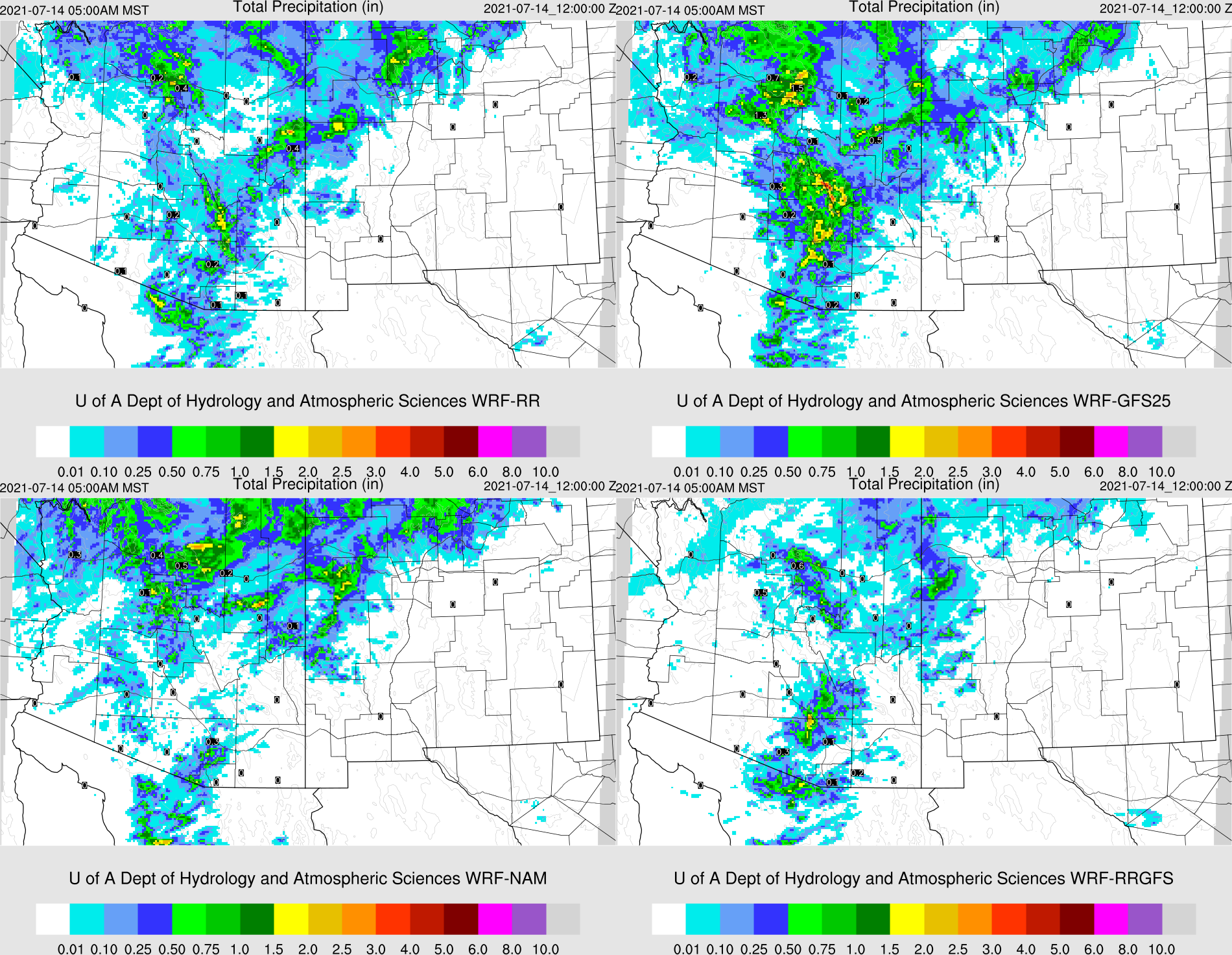
It's a complicated situation due to the ongoing activity. Initializations before 12Z didn't have nearly enough clouds or precipitation over NW Arizona. The 12Z RR had more clouds, but not the storms. The 12Z NAM had too much activity in NW Arizona. There is still a lot of smoke around, and the GEOS5 AOD forecast seems to have a handle on it. PW was initialized well except for the 6Z NAM, which had some large southern Arizona and NM errors. It looks to me like the 12Z RR had the best initialization.

Day 1
Weak moisture advection continues up the Gulf of California, resulting in moist air over most of the state today. The dryline is along the AZ/NM border.


It's no surprise that some strong/severe storms develop in this area during the afternoon.

What is a bit of a surprise is that Tucson seems to recover quite well after last night's activity. CAPE increases to around 700 to 1000 J/kg, and the PBL is mixed quite deeply. Steering flow is good as well as some low-level shear. Anvil shading may be less of a concern as upper winds are NNE while steering flow is easterly.


Many of the runs are predicting activity again for the Tucson area by the evening.

Later in the evening, storms continue southeast of Phoenix along an outflow boundary that moves to the NW.

The 6Z WRFGFS and 9Z WRFRR are a bit more active, including a few storms in the Phoenix area later this evening.

After midnight, the trough axis is located from western Arizona to NE Arizona. While CAPE isn't very high, there is plenty of moisture, so there is the potential for early morning.

A few storms may continue to roam around central Arizona into the morning hours. There is not much model consensus as some have more and some have none.


As seen in the 4-panel plot, the WRFGFS is the most active and has heavy precipitation for central and northern Arizona. The WRFRR doesn't seem to have enough, as I would expect more due to the trough.
Day 2
The 500mb shortwave trough moves into NM while the anticyclone is located somewhere near Vegas, resulting in favorable NE flow over much of the state.

Moisture is more than enough (>=10C) to supports storms over central and eastern Arizona. The dryline has been pushed back into NM.


No comments:
Post a Comment
Note: Only a member of this blog may post a comment.