Previous Forecast
It was an active afternoon and evening for much of the mid and high elevations of the state. A large area of strong storms developed in southeastern Arizona and made a run for Tucson but weakened as it moved in. A giant MCS rampaged through Sonora and is still active this morning.
 |

Most of the runs performed well, especially considering the complex nature of the initializations yesterday. The QPF for southeastern Arizona was pretty good. Q3 estimates for some storms north of Phoenix were over 3.5", which the WRF could not duplicate. The 15Z WRFRRR was the best overall.

As they say back in the home country, Minnesota, Uff Da! A 598dm or greater ridge dominates the western CONUS.....again. A weak IT or MCV is located between Phoenix and Tucson. It is responsible for clouds and a few showers around Phoenix. With the ridge in this position, shortwaves can break off from the westerlies and become inverted troughs that pass through Arizona from time to time. There is a trough dropping down over Oklahoma now, and perhaps some vorticity will get sheared off and move westward. I'll see if that is the case later.

PW has generally stayed the same for much of southeastern Arizona, around 40mm at Tucson, and bounced back to the upper 40's out west. However, note the drying (in the GOES imagery below) over western NM and far east-central Arizona from subsidence due to the building mid-level anticyclone. Both ABQ and ELP have subsidence inversions at ~500mb.

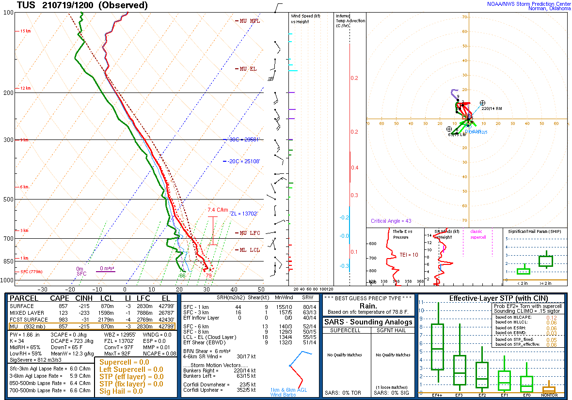
For the first time in a few days, only minimal MLCAPE is present at Tucson as the atmosphere is worked over. The wind profile is also poor, as it's light and variable all the way to 300mb. Based on the Skew-T, Tucson should be mainly quiet, but storms are likely to form over the nearby mountains but not move much. Heavy rain is a threat.
Phoenix has a fair amount of elevated CAPE, as well as some MLCAPE. Winds are considerably better for steering storms from the east into the lower elevations. The problem there is the thick clouds reducing heating, but it still looks better than Tucson.

Initializations
As seen in the GOES imagery above, widespread clouds and a few showers are present. The situation is less complicated than yesterday, but still not simple. Satellite animation indicates another IT/MCV over SW NM, moving eastward. I'm not sure if this was the IT that was identified in eastern NM yesterday. 6Z initializations had a lot of issues and won't be used today. The 9Z RR had way too many clouds over eastern AZ and western NM. I don't know what the deal is with the RR, as the 12Z is also way too cloudy. It did manage to initialize the Sonoran MCS, though. My list of possible model runs is getting short! The NAM wasn't as cloudy but still has too much. It managed to initialize weak waves near El Paso, between Phoenix and Tucson, and another in far northern Sonora, which all look OK. All initializations have major errors resulting in low model forecast confidence.
I've been patiently awaiting the 15Z RR, hoping that it can do a better job, and while not perfect, it has significantly less cloud cover over eastern Arizona. It also has a pretty good handle on the various troughs/MCVs. This is the one.

Day 1
The long-duration surge event has finally come to an end, despite the big MCS in Sonora and a westerly push of drier air is underway.

There is no agreement between the different morning runs for CAPE. The 12Z WRFRR has it mainly over far eastern Arizona,, which looks right as widespread cumulus is forming there now. However, it doesn't look high enough for the Phoenix area.

The 15Z WRFRR has only limited activity by later afternoon.


It looks a little better for Phoenix as the PBL is mixed deeper, but CAPE is marginal. It looks unlikely for any activity for Tucson or Phoenix.


Day 2
The drying trend continues as low-level easterlies push the moist air back to far western Arizona.


Storms are scattered about those areas during the afternoon hours.


Phoenix is a little better, but activity is still unlikely.

I wrote the above about Day 2 before the 15Z WRFRR became available. It has much more CAPE and moisture as it doesn't push the dryline as far east. I find it disturbing the large differences between the 12 and 15Z WRFRR and gives me no confidence in the day 2 forecast.


Earlier I mentioned that the pattern was favorable for a piece of a trough to break off and become a westward IT, and this is forecast to happen, so look for a big upswing in thunderstorms in a few days.

No comments:
Post a Comment
Note: Only a member of this blog may post a comment.