Previous Forecast
Wow, what a night for the eastern/southern parts of Phoenix! Severe storms moved rapidly info the northeast a proceeded all the way to Yuma. I'm not sure if they initiated in NE Arizona, as discussed yesterday.


This was the velocity scan as the storm was moving into the east valley. Estimated speeds were 75mph. The whole storm was also rotating!


Most of the model runs had the right idea of moving storms south of Phoenix during the evening hours. A couple of runs nailed it, like the 6Z/12Z WRFGFS and 9Z WRFRR. However, I went middle of the road as it's always difficult to figure out which run is correct.


What really surprised me was that the WRF runs predicted the general location and timing far in advance. Here are a WRFGFS forecast 42 hours in advance.


I had mentioned the HRRR yesterday, and it wasn't even close. The score is WRF 2, HRRR 1.

Discussion
That is enough patting myself on the back, which is always dangerous, as it provokes the weather gods to smite me with a big bust sometime soon. Let's start with the 500mb map big picture. Here we go again with another 12Z map with a 6000m height as the anticyclone has intensified. Maybe another world record high temperature in Death Valley today? Temperatures are an unfavorable -3 to -4C over southern Arizona, as well as the easterly "jet" of 30-45 knots. There is some "cooler" air in NM as Alburquerqe is at -6C.

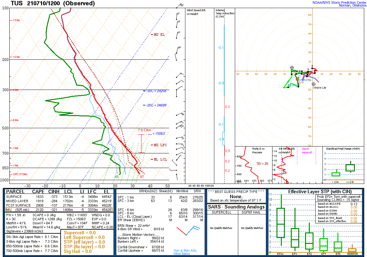
Moisture has generally decreased in western Arizona but increased in the far eastern parts. Tucson has around 35mm as well as an impressive amount of MLCAPE, 1900 J/kg. There is a pronounced cap at the top of the shallow moist layer, but I think that would go away with sufficient heating. Steering continues to be excellent with 20-30 knots of ENE flow. It certainly looks like a big day in and around Tucson. The Phoenix 12Z sounding was missing.
Initializations
Most clouds have either dissipated or moved into California, so skies are mostly clear. GOES PW shows the eastward push of the moisture almost into NM. All initializations have clouds, or the lack of them, initialized well.

PW is also initialized well by the GFS and RR. There are no obvious cyclonic circulations in either the upper-air data or satellite imagery. The GFS and RR are favored, and WRF performance should be good. 12Z RR is suspect as it didn't have nearly enough CAPE initialized for Tucson at 12Z.
Day 1
Some moisture advection continues, thanks to an ongoing shallow Gulf Surge. However, at 850mb, dewpoint temperatures aren't as high as they are around 10 to 12C, but they are still sufficient to support deep convection. Western Arizona may be a little drier due to subsistence in the wake of the storms that moved through early this morning. The dryline has been pushed back to the AZ/NM border, and this boundary may act as an area of convergence, helping storms form and intensify. The various runs disagree somewhat about the east-west positioning of the boundary.

CAPE is forecast to be high for much of eastern Arizona this afternoon. The 12Z WRFRR has significantly less moisture/CAPE for SE Arizona, which doesn't look correct as it's much less than observed on the 12Z Tucson sounding. I'm going to be skeptical of that run.

Storms don't really get going until later in the afternoon and mainly over far southeastern Arizona. My guess is because the low-level cap is keeping deep convection in check for much of the day.

The storms move to the southwest and intensify into the evening. Some storms are severe and will produce damaging winds. Model wind forecasts are over 45 knots. Thus gusts are possible over 65 knots. Not surprising as Tucson 12Z observed DCAPE was 1300 J/kg.


There is quite a bit of disagreement about what happens this evening, but the general idea is to move these severe storms into the lower deserts from Tucson to as far north as Phoenix. Some runs develop another area of organized storms to the northeast of Phoenix as storms again initiate on the Chuska Mountains in NE Arizona during the late afternoon. (15Z WRFRR)


Others have the activity farther south, moving them towards Pinal and eastern Pima Counties. In any case, the message is widespread strong to severe storms over much of southeastern and south-central Arizona this evening.

No matter what model run I look at, both Phoenix and Tucson look excellent for widespread severe storms as these are some of the best forecast Skew-T plots I've seen in a long time. Both have excellent NE steering flow and strong moist low-level westerly flow producing great shear. CAPE is from 1000-2400 J/kg, and the mixed layer is fairly deep. Both will need a good outflow boundary to trigger deep convection, and as seen above, storms are forecast to produce strong/severe winds.


12 and 15Z WRFRR runs dissipate storms as they move towards Tucson, which I'm not sure I agree with due to the above Skew-T (from the WRFRR!). However, they move the Chuska Mountain storms into Maricopa and Pinal Counties during the evening, much like last night. The storms look more severe than last night.


The WRFGFS and 9Z WRFRR have severe storms somewhat more south, in Pinal and eastern Pima Counties.


Storms generally weaken as they move into western Arizona, but it looks likely for a big haboob.

Day 2 follows later.
No comments:
Post a Comment
Note: Only a member of this blog may post a comment.