Previous Day
Clouds parted long enough to allow sufficient heating for early evening thunderstorms around the Tucson area. Both 12Z runs were pretty good as they both had activity in and near Tucson except they were a few hours early.
Initializations
Another difficult situation for the model initializations as widespread clouds and some areas of showers are again present. All initializations are terrible with little or no clouds. The 12Z NAM being slightly less bad as at least it had some clouds approximately in the correct locations but they quickly dissipated by mid morning. Lack of clouds are likely to cause problems with amounts and timing of deep convection and model confidence is low.
There is a mid upper IT present over northern Baja moving west while smaller cyclonic circulations continue to rotate around it with one passing through the Tucson area. Another mid level IT is stalled in west Texas and seems to be slowly shearing apart. The large scale features are initialized OK.
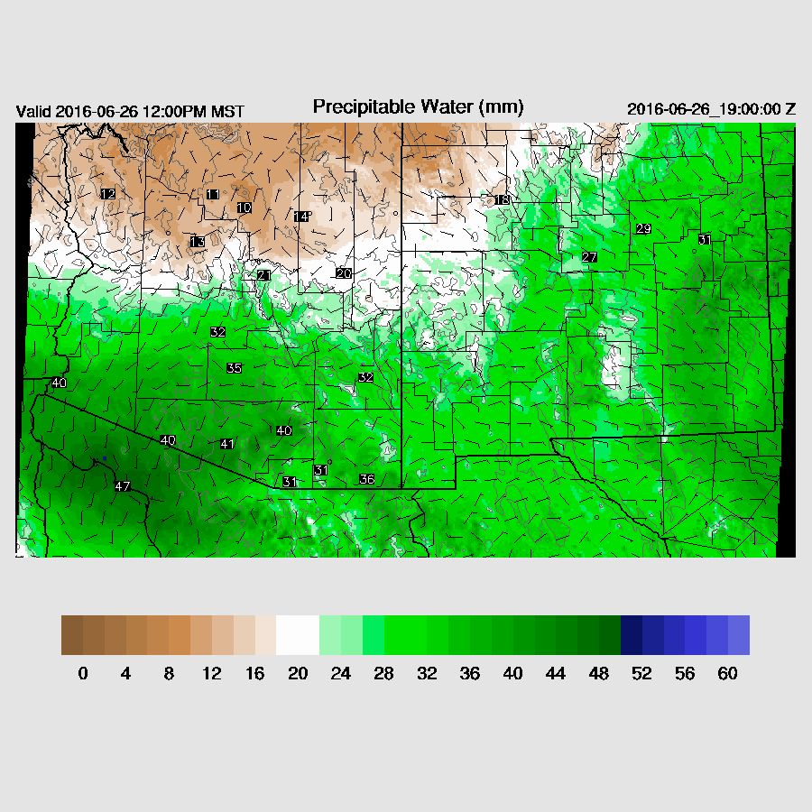
Precipitable water was initialized OK by both of the 12 initializations.
Day 1
Moderate amounts of moisture continue across SE and into central Arizona while dry air wraps around the departing Baja IT, into far SW Arizona while dry air advects into NE Arizona from NM.

At 500mb, flow across the state is a decent 15-25 knots from the ESE thus higher elevation storms could be moved into lower elevations. Temperatures are around -6 to -8C with warmer air off to the east which may act to eventually suppress convection over southeastern Arizona.

There is quite a difference between the WRFGFS and WRFNAM CAPE forecast as the WRFGFS has quite high CAPE in far SE Arizona. With morning clouds widespread, this is probably too high and the WRFNAM looks to be more accurate. Compared to the previous day runs, it's looking less likely for much activity in/around the Phoenix area as CAPE is low there.

A few storms form by early afternoon along the US/Mexico border as well as over the Rim and White Mountains as seen in the WRFNAM below. The WRFGFS is more active and moves some storms into the Tucson area by late afternoon, but I think this less likely due to the lack of heating.

By early evening, storms continue across SE Arizona and along the Rim and west of there, moving west towards the Colorado river.

The forecast Skew-T diagram for the Phoenix area does have some CAPE and is well mixed so there is a slight chance of some activity in and around the area. It's more likely that storms stay to the north and east and don't make it into the lower elevations.

What is more likely is a strong outflow into the valley by late afternoon or early evening.

Day 2
Easterly low level flow becomes quite strong across western NM into eastern Arizona with dry air across NE Arizona. However, from a line from Tucson to approximately Flagstaff, wet air remains. Sometimes, this back door pseudo dryline front can act as a focus for convective initiation.

The 500mb warm air that was over SE NM now advects into SE Arizona which will suppress convection there. Steering flow also becomes less favorable as wind speeds are only 10-15 knots.

The WRFNAM and WRFGFS are quite different as the WRFGFS has much more CAPE over south central into SW Arizona while the WRFNAM (below) has much less. SE Arizona and into SW NM CAPE is quite high in spite of low level easterly flow.

Most deep convection is restricted to areas west of Flagstaff and west of Tucson. Eastern Arizona is either too dry or suppressed. In spite of differences with CAPE, both the WRFGFS and WRFNAM are very similar.

Most activity dissipates during the evening with only isolated storms east of Phoenix.

An interesting situation late tomorrow night as CAPE is forecast to become quite high across SE Arizona and into the Phoenix area. Both 12Z model runs are quite similar.

CAPE and IPW increases during the late evening and results in a quite unstable atmosphere.

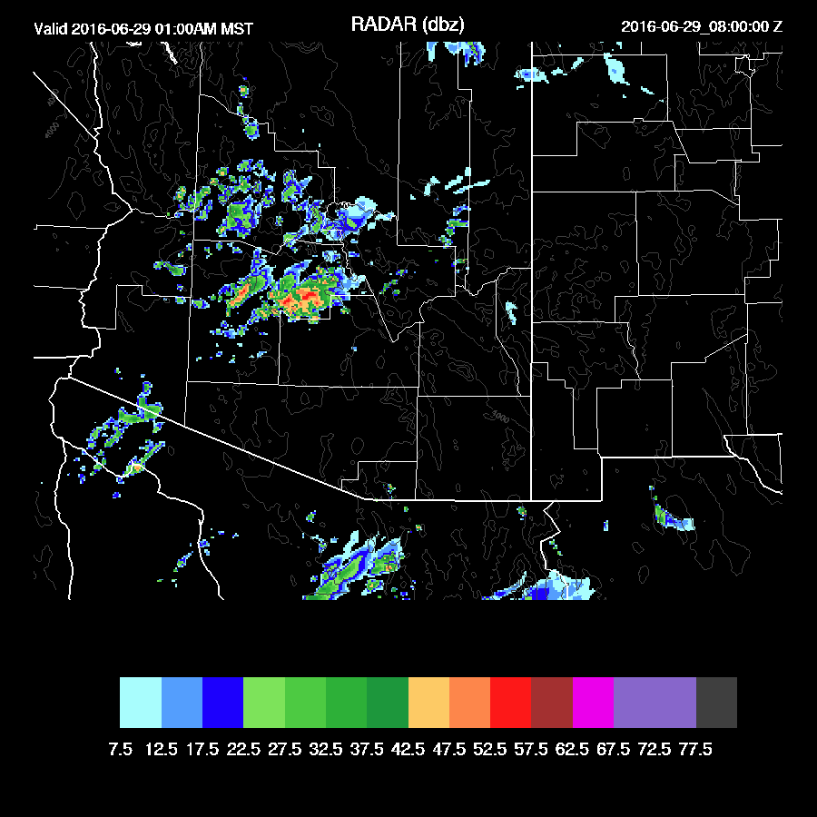
The weak storms to the east of Phoenix move into the valley and some become strong during the overnight hours and remain active into the early morning. Both model runs are quite similar so there is some confidence in this unusual event.
Clouds parted long enough to allow sufficient heating for early evening thunderstorms around the Tucson area. Both 12Z runs were pretty good as they both had activity in and near Tucson except they were a few hours early.
Initializations
Another difficult situation for the model initializations as widespread clouds and some areas of showers are again present. All initializations are terrible with little or no clouds. The 12Z NAM being slightly less bad as at least it had some clouds approximately in the correct locations but they quickly dissipated by mid morning. Lack of clouds are likely to cause problems with amounts and timing of deep convection and model confidence is low.
There is a mid upper IT present over northern Baja moving west while smaller cyclonic circulations continue to rotate around it with one passing through the Tucson area. Another mid level IT is stalled in west Texas and seems to be slowly shearing apart. The large scale features are initialized OK.
Precipitable water was initialized OK by both of the 12 initializations.
Day 1
Moderate amounts of moisture continue across SE and into central Arizona while dry air wraps around the departing Baja IT, into far SW Arizona while dry air advects into NE Arizona from NM.

At 500mb, flow across the state is a decent 15-25 knots from the ESE thus higher elevation storms could be moved into lower elevations. Temperatures are around -6 to -8C with warmer air off to the east which may act to eventually suppress convection over southeastern Arizona.

There is quite a difference between the WRFGFS and WRFNAM CAPE forecast as the WRFGFS has quite high CAPE in far SE Arizona. With morning clouds widespread, this is probably too high and the WRFNAM looks to be more accurate. Compared to the previous day runs, it's looking less likely for much activity in/around the Phoenix area as CAPE is low there.

A few storms form by early afternoon along the US/Mexico border as well as over the Rim and White Mountains as seen in the WRFNAM below. The WRFGFS is more active and moves some storms into the Tucson area by late afternoon, but I think this less likely due to the lack of heating.

By early evening, storms continue across SE Arizona and along the Rim and west of there, moving west towards the Colorado river.

The forecast Skew-T diagram for the Phoenix area does have some CAPE and is well mixed so there is a slight chance of some activity in and around the area. It's more likely that storms stay to the north and east and don't make it into the lower elevations.

What is more likely is a strong outflow into the valley by late afternoon or early evening.

Day 2
Easterly low level flow becomes quite strong across western NM into eastern Arizona with dry air across NE Arizona. However, from a line from Tucson to approximately Flagstaff, wet air remains. Sometimes, this back door pseudo dryline front can act as a focus for convective initiation.

The 500mb warm air that was over SE NM now advects into SE Arizona which will suppress convection there. Steering flow also becomes less favorable as wind speeds are only 10-15 knots.

The WRFNAM and WRFGFS are quite different as the WRFGFS has much more CAPE over south central into SW Arizona while the WRFNAM (below) has much less. SE Arizona and into SW NM CAPE is quite high in spite of low level easterly flow.

Most deep convection is restricted to areas west of Flagstaff and west of Tucson. Eastern Arizona is either too dry or suppressed. In spite of differences with CAPE, both the WRFGFS and WRFNAM are very similar.

Most activity dissipates during the evening with only isolated storms east of Phoenix.

An interesting situation late tomorrow night as CAPE is forecast to become quite high across SE Arizona and into the Phoenix area. Both 12Z model runs are quite similar.

CAPE and IPW increases during the late evening and results in a quite unstable atmosphere.

The weak storms to the east of Phoenix move into the valley and some become strong during the overnight hours and remain active into the early morning. Both model runs are quite similar so there is some confidence in this unusual event.
 |
| WRFNAM |
 |
| WRFGFS |