Previous Forecast
It was one of the more active late afternoon and evenings so far this monsoon season and the most active for western Arizona. Storms developed east of Phoenix and ejected multiple outflow boundaries which were sufficient to kick off a few thunderstorms. Severe storms also developed over western Pima County. Later, a complex of storms moved through the Parker area, bringing power outages and damage.
It was a problematic forecast as there was no consensus with the model runs and the spread was from very active (WRFNAM) to not much, (most WRFRR runs). The potential was certainly there, as pointed out yesterday. Also of interest, is both the WRFNAM and WRFGFS day 2 forecasts from the 31st verified well. The WRFNAM was best (including the 6Z run), by far, yesterday. Too bad I didn't get it more weight. It didn't have enough activity around the Tucson area where there was quite a bit of activity into the early evening.
The 15Z HRRR did no better than the WRFRR runs.
Initializations
The 500mb pattern is mainly the same as the moderate southeasterly flow over Arizona and coolish 500mb temperatures of mostly -8C. A weak IT may be located over Sinola while a tropical system is spinning up south of Cabo San Lucas. Will it be a player in our weather in a few days? I hope so. Model initializations all look accurate for upper-air features and clouds.
The main issue is how well the initial conditions handle the widespread worked over atmosphere. Both Tucson and Phoenix soundings look worked over. As of 16Z, the WRFNAM has the best T@2m forecast as the RR is too warm. Because of this, I'd think the WRFNAM may be the most accurate today.
Day 1
PW has generally decreased in the wake of the widespread activity, and this continues into the afternoon. The low-level easterlies have reduced in far eastern Arizona, allowing moisture to increase slightly.
850mb dewpoints have decreased but are still sufficient for some activity.
The WRFNAM is slightly wetter, resulting in a bit more CAPE than the RR. It's hard to say which is correct.
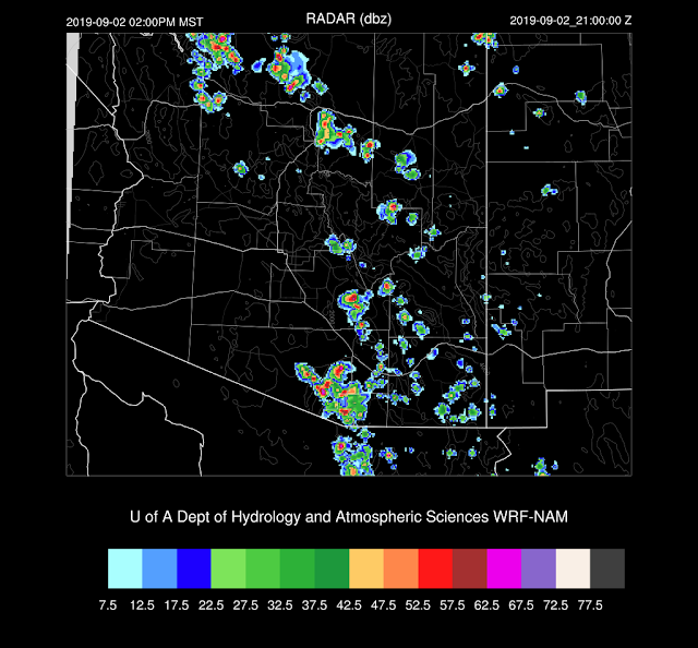
Both runs develop storms over the higher terrain with the WRFNAM having a bit more activity.
The wind profile is favorable, and the PBL is deeply mixed, so a few storms are possible. They will be weak as CAPE is only around 300 J/kg.
The WRFNAM does manage to move a few storms through Tucson this afternoon. Most activity will be over the higher elevations.
The WRFRR has no CAPE for the Phoenix area this evening. The WRFNAM has quite a bit, but the convective boundary layer is shallow and unlikely to convect as only weak storms are in the vicinity providing insufficient OFBs.
Day 2
The situation isn't any better tomorrow as PW ranges from 30-35mm for the Tucson and Phoenix areas. CAPE is low to moderate.
The warm air is back at 500mb, and you know what that means.
Low PW + -5C@500mb = #sad
The tropical system that isn't Hurricane Dorian moves mostly west and isn't close enough to trigger a surge. #sad x 2


No comments:
Post a Comment
Note: Only a member of this blog may post a comment.