There were a few areas of thunderstorm activity over mainly far southern Arizona and northwestern Arizona. There was a large area of mainly light precipitation, which was a nice respite from the heat.

The model runs had the right idea of mainly light activity over the state. They mainly missed the convection over NW Arizona, except for the 15Z WRFRR.

Discussion
Moisture has increased quite a bit since yesterday as PW is now mainly in the mid to upper 30mm range over the lower elevations. Even wetter air is in place over Sonora as Hermosillo is around 55mm which is the wettest so far this season. The 500mb map is finally looking better for Arizona as heights continue to decrease and temperatures cool to around -7C. However, the mid-level flow light and variable so it's always something missing it seems.

The Tucson sounding looks better as at least there is finally some CAPE. Steering flow isn't as bad as it looks on the 500mb map as there is a bit of easterly flow around 700mb. Upper winds are quite strong from the SW, ahead of an upper trough.

This trough is an interesting feature as it's providing upper divergence over southern California. I've not seen the forecast yet, but I would assume it is going to move towards Arizona and at some point, help to enhance storm activity.


Initializations
There are widespread clouds and showers over all of eastern Arizona thus it's going to be a challenge to get this activity initialized correctly. I see a weak IT located in northern Sonora in morning satellite imagery, as well as an area of deep convection ongoing over southern Sonora. The 12Z RR and 6Z GFS initialized well except for the Sonoran storms. The NAM has really been struggling recently as it's ongoing wet bias is causing too much deep convection shortly after the WRF starts to run. Below is an image from the 6Z run showing all sorts of storms over eastern Arizona when in reality, only light showers were present. I think this is mainly due to the wet bias that it has, which was again the case over much of Arizona where it initialized up to 7mm too moist. I did contact NCEP about the bias last year and I was told that the NAM configuration was frozen and it just happened that GPSIPW assimilation was turned off due to a temporary problem. To get around this issue, I've started replacing the initial conditions with the Rapid Refresh, but am still using the NAM LBC's. This is only the case for 18 and 0Z where this anomalous convection has been a big issue, but I may also replace it at 6Z. Ultimately, I may replace many of the NAM runs with RR, at least for the summer warm season.

Day 1
A surge continues to advect increasing PW into Arizona today. It's still mainly an outflow induced surge, but it's one of the better ones so far this season. I think there has only been one surge that was along the entire length of the Gulf of California which was caused by the traditional method when a tropical system approaches the southern Gulf.

With the cooling aloft and increasing moisture, we finally have a high CAPE situation over parts of the state. Due to clouds and showers, eastern Arizona has only low CAPE, but it's sufficient to support a few storms assuming the sun can break through the clouds.

The interesting part of the state is from about Phoenix, westward. Phoenix has around 1000 J/kg by early afternoon, but there are a couple of inversions to overcome, and steering flow isn't very good. The potential is finally there though.

Storms develop over the higher terrain by mid-afternoon. The storms north and east of Phoenix are likely to eject some outflows into the lower elevations around Phoenix and could trigger additional storms by early evening.

Well, look at that! The WRFRR manages to develop a few storms in and around both Phoenix and Tucson this evening.

Confidence is low in any one deterministic forecast as every run has been different for this afternoon and evening. The 12Z WRFNAM develops an intense tropical squall line over far southern Arizona and northern Sonora which results in a large anvil over SE Arizona, suppressing activity there.


Day 2
Very moist air continues to advect into Arizona resulting 40 to over 50mm of PW. Needless to say, very heavy rain and flash flooding are a risk.


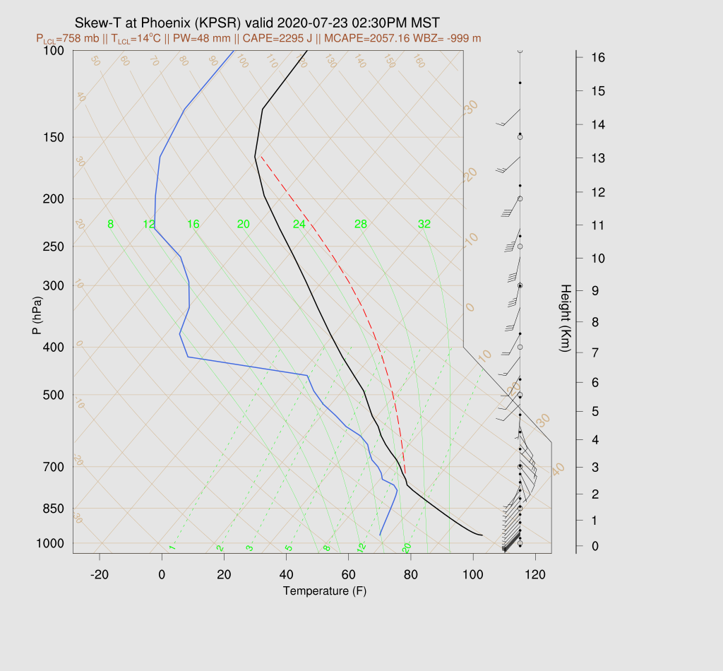
It sure looks like Phoenix is primed for a major severe weather event as all the ingredients are there. The afternoon forecast Skew-T has over 2000 J/kg of CAPE, a PBL mixed nearly to the LFC/LCL, a weak inversion at the top of the mixed layer, and a good wind profile! Wet microbursts will cause strong to isolated severe winds and other risks are frequent lightning and heavy rain.
There may be some upper support as a jet steak is present over northern Arizona, placing central Arizona in the right entrance region resulting in divergence aloft.

Storms develop during the afternoon over the Rim and White Mountains and over the higher terrain of far southern Arizona. Tucson gets a big anvil from the nearby activity which results in not much activity. All runs are quite similar so at least this part of the forecast has some confidence.

Storms increase in intensity and coverage and move into the Phoenix area during the evening hours.

The WRFNAM trains storms over the Phoenix area throughout the night resulting in some amounts over 3 inches. Generally, the forecast confidence for locations and timing is low as this is such a complex situation, but it sure looks like some locations in central Arizona are going to see strong to severe storms with some flash flooding, tomorrow evening.

No comments:
Post a Comment
Note: Only a member of this blog may post a comment.