Remnants of Lorena are located just north of Isla Tiberon or west of Hermosillo. Some deep convection is present in the northeastern quadrant. Mario is still a tropical storm but devoid much deep convection and is located just southwest of Cabo San Lucas. All morning initializations have these features initialized well. The NAM has issues with southern NM initializing too wet, and the GFS has a web bias at a few sites in eastern Arizona and northwestern Sonora. The 12 and 15Z WRFRR appear to have the best initializations.
Day 1-2
The big day is almost upon us. This is one of the more unusual situations that I've seen for transition season as I can't recall ever having a cutoff low that drops down and stalls over Arizona when there is this much moisture available. The 300mb map has a strong 125+ jet off the NW CONUS that will result in a trough digging down towards Arizona by tomorrow. Even then, there is still a >60 knot jet on the backside of the 500mb low which will result in further digging.
What about moisture? By late afternoon, moisture moves into the far southern parts of the state. There is plenty more in Mexico! Mario moves slowly to the northwest keeping southerly winds going over the southern Gulf of California, and moisture moving northward. CAPE is limited, so little or no activity is expected this afternoon and into the evening.
CAPE increases significantly during the early morning hours over south-central Arizona in some of the forecasts. This results in a few storms developing around sunrise. The 15Z WRFRR has some quite strong storms.
This region is in the favorable right entrance region of a 250mb jet streak, which produces upper divergence/PVA resulting in rising motion, more or less in the area outlined.
Morning storms could be very strong and exhibit organization and supercell characteristics as directional and speed shear are excellent.
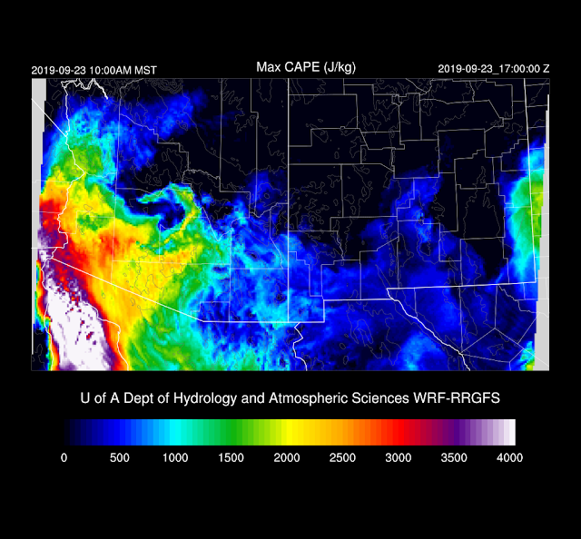
CAPE increases over western Arizona to extreme values of over 3000 J/kg.
With the approaching height falls, cold air advection, and PVA, western Arizona is primed for a major severe weather event. Strong to severe storms develop during the late morning to early afternoon hours.
Wow! Impressive CAPE and veering winds with height. There is pronounced inversion at the top of the mixed layer, but cold air advection should erode that away for areas north of Yuma. Large hail and even some tornadoes are possible with this kind of wind profile.
At this point, the various model forecasts go off all over the place. Moisture continues to surge northward into the early afternoon.
Generally, strong to severe storms are possible anywhere over the state tomorrow afternoon except for southern Arizona. Here's a sample of the various model forecasts:
By late afternoon, the low still exhibits strong digging characteristics with > 50-knot winds on the backside.
Southern Arizona stays capped until evening. CAPE increased to around 1300 J/kg and the cap weakens as the trough approaches, so some storms are possible during the evening hours.
CAPE continues to be moderate to high during the evening hours, so the potential for strong to severe storms continues. It's not possible accurately say where or when.
Day 3
There is still some disagreement between the WRF and GFS/ECMWF in regards to the location of the cutoff low. The WRF has it over far south-central Arizona, while the ECMWF and GFS are over southwestern Arizona. With the low farther to the west, eastern Arizona is likely to be more active than the WRF is saying for day 3.


No comments:
Post a Comment
Note: Only a member of this blog may post a comment.