Wednesday, June 21, 2017

20170621

Previous Forecast
Not a good day for the model runs and I neglected to pick up on some clues that indicated they were going to be too active.  Stronger storms were mainly restricted to the higher terrain of parts of SE Arizona with very weak activity around Tucson.  Below is the lightning plot as the QPE product from NOAA/OU (http://nmq.ou.edu/) is no longer available.  For whatever reason, NOAA had decided to make those products internal and not available to anyone else.  I've tried to get access but have been denied.


As mentioned, there were quite a few clues that the forecasts were going to be bad.  The first was that Tucson area IPW started dropping during the late morning hours while the model held steady or even increased slightly.  Another problem was the IT the model runs had initialized south of Douglas was not there.  Later in the morning, I could find no evidence when looking at cloud motions and I should have looked harder when evaluating the initializations.  The area of clouds that moved through during the morning also restricted heating a little.  By late morning, it was clear there was too much forecast activity by just looking at the lack of development.  Not a good way to start the season.

Initialization
No significant errors noted.

Day 1
500mb heights have come down a little so not quite as hot today but moisture has increased slightly.  Even a weak Gulf of California moisture surge is underway as dewpoints are in the 50's there.   Quite a bit of moisture is lurking just to our south over western Mexico and some of this continues to trickle into Arizona today.

In spite of this low-level increase, only far eastern and southeastern Arizona have sufficient CAPE to support deep convection.

 Scattered storms are present during the afternoon for this area.

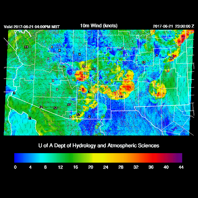
 The Tucson forecast vertical profile has only minimal CAPE and unfavorable winds.  Mt Lemmon might see a quick afternoon storm though. A deep inverted v profile will again cause storms east of Tucson to have very strong winds associated with them.

By late afternoon, areas of EC and SE Arizona as well as into SW NM may experience very strong winds.

Day 2
No significant weather expected as moisture is limited over higher terrain.  A weak surge continues to advect low-level moisture which will increase dewpoints into the 50's in western and central Arizona.


Tuesday, June 20, 2017

20170620

Previous Forecast
The various model runs were quite good forecasting the strong outflows over far southeastern AZ and SW NM where there was a terrible accident where the freeway crosses the Lordsburg Playa.  I was driving back from Paradise on I-10 shortly after the dust storm and at that point, the freeway had been closed.  It was spooky driving on an empty I-10 except for occasional tow trucks and emergency vehicles going the other way towards NM.  WRF-GFS was the best and is below.


Initialization/Discussion
The WRF runs are not all configured for the summer convective season yet and may have some issues with forecasting convection correctly.  Most runs will be transitioned over the next few days.

Southern NM was very active last evening which resulted in debris clouds advecting in over southern Arizona.  The key for today is if these clouds will thin out enough to allow sufficient heating for afternoon convection as IPW has increased to 26mm at Tucson.   Unfortunately, far SE AZ and far SW NM do not have any functioning GPSMET IPW stations so it's hard to say what is immediately upstream from us.  Demming is 28mm so southern NM is wet.

Of course, the first day back is tough as no model run has enough clouds; even the one that uses the new setting that is supposed to improve cloud coverage.  Because of overnight warmth, we got a head start on heating so, in spite of clouds, we're pretty close to the models.   


Looking at upper level maps, there does seem to be a weak inverted trough between Tucson and El Paso which is either a leftover MCV or an inverted trough.  In any case, this trough should help organize convection.  The 12Z NAM has a fairly sharp 500mb trough located just south of Douglas which looks OK.  The 6Z GFS is similar.   The 6Z WRFGFS also had the best cloud coverage of the morning models, but still not enough.  Model confidence is quite high as the clouds over SC Arizona are burning off quick enough to not be a big factor.

Day 1
Moisture continues to slowly increase over eastern Pima and Santa Cruz during the morning hours and is more than enough for deep convection.

CAPE is also very high for this time of year in SE Arizona with some values exceeding 2500 J/Kg.  NM also have very high CAPE.  

Deep convection forms over the high terrain of Santa Cruz County by early afternoon.

As mentioned by Dan Henz this morning, the mixed/sub cloud layer is very deep, extending to nearly 500mb.  The lower/mid level wind profile is also very good with mid-level easterlies and low-level northwest winds.  CAPE is low in the Tucson area but may be enough to support storms even in the lower elevations.
Storms are present over eastern Pima County later this afternoon while storms over the White mountains are just getting started.

Winds are going to be very strong with gusts above 50 knots in eastern Pima County with these storms.  It appears storms will put the break on temperatures so perhaps Tucson won't have record highs. 

The rest of SE Arizona becomes very active by late afternoon as outflows converge across Cochise County, triggering new development.  The big story is the winds as it looks like a repeat of yesterday with very strong outflow winds. 

A few storms form in far eastern Pinal County and eject outflows into the Phoenix area this evening accompied by a dust storm.  Strong winds continue over SE Arizona.

Due to slightly cooler/wetter air, it looks like Phoenix won't make it to the 'magic' 120 mark.  It's going to be close and maybe KLUF can do it.

Looks like the outflows provide some cooling for Phoenix this evening.

A Day 2 update will follow later this morning.