Thursday, June 30, 2022

20220630

Previous Forecast

All good things must come to an end.  WRF had been doing well this monsoon season until yesterday as the forecast didn't go as planned for the Tucson or Phoenix area.  It went off the rails early as widespread strong storms developed to the west of Tucson by early afternoon, resulting in a cooling outflow and anvils overspreading the valley.  As the forecast for Phoenix was contingent on big storms moving from Tucson up I-10, that didn't work out there either.  Besides those two areas, WRF did a reasonable job, except for precipitation amounts.


Discussion

The monster CONUS anticyclone continues and is centered over Kansas.  A weak trough is present over the SW US, resulting in weak southwesterly winds over the northern 1/2 of the state.  500mb temperatures are still quite cool, around -7C.


The morning soundings indicate only a limited amount of CAPE.  Phoenix exhibits a "green onion" profile indicating a worked-over atmosphere, despite storms mostly staying out of the metro.  Tucson isn't worked over, but MLCAPE is essentially zero, despite a nearly saturated "heavy rain" profile above 700mb.  PW is relatively high at Tucson, with a peak of 41mm around 12Z.  The Phoenix wind profile is mainly unidirectional from the SW.  Tucson is a better, with southwesterlies above 500mb and southeasterly 10-15 knot steering flow.


Initializations
A weak MCV was noted near Flagstaff, moving northeast.  WRF, to its credit, did spin up a similar feature yesterday.  There is a much larger MCV over central Sonora as there was a large MCS yesterday and last night.  Widespread clouds are associated with both features.  All initialized the Arizona MCV OK.  Only the RR did a fair job with the Sonoran MCV.  The 6Z GFS initialized clouds well.  The HRRR didn't have enough, especially in Mexico, and some RR initializations had too much.  The GFS and 15Z RR appear to be the better initializations.


Day 1
An outflow-induced Gulf Surge appears to be underway as Yuma has 15 knot SE winds and a dewpoint of 70F.  It looks quite shallow, as PW has increased only slightly.  Moisture continues to advect into Arizona during the day, keeping PW in the mid-30 mm range.

850mb dewpoints are also relatively high, at around 10 to 12C.

Lastly, CAPE is moderate, mainly over southeastern Arizona, so that looks like the favored area today.

Deep convection develops during the afternoon, mainly over the higher terrain from Flagstaff eastward and over the higher terrain of SE Arizona.

Tucson has just enough CAPE to support some deep convection, but there are issues.  The first is that the wind profile becomes mainly southwesterly, with minimal steering flow.  The second is a bit of an inversion on top of the mixed layer.  Also, note the double structure of the mixed layer, with a wetter layer (due to the surge) below 850mb.  This could also impede mixing to the LFC.

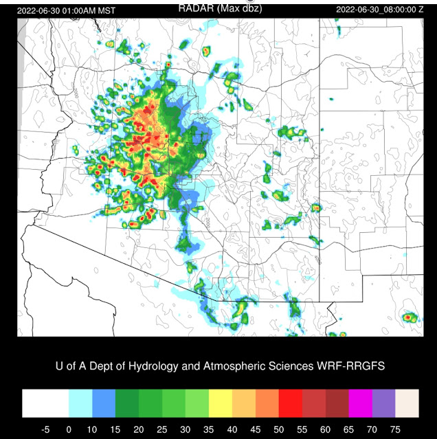
Most morning runs develop strong to isolated severe storms over far southern Arizona by early evening, but most stay out of the Tucson valley.  Still, with a strong enough outflow, there is enough CAPE to support a few storms.

Phoenix has just enough CAPE to also support a few storms.  Like Tucson, the vertical wind profile is poor, and the PBL needs to mix quite a bit higher for storms, so a strong OFB will be required for widespread deep convection.

Some activity to the north of Phoenix this evening, resulting in some outflow boundaries moving into the valley.  Some runs develop a few storms, similar to last night.  The best is the 15Z RR which has a few strong storms in Phoenix later this evening.  Hope for the best!

Day 2
As very dry air moves into western Arizona, a distinct drying trend begins for the state.  Dry air is also developing over southern NM.  Elsewhere, moisture continues to advect into the state due to an ongoing Gulf Surge, perhaps driven by another MCS in Sonora.

CAPE is forecast to be higher from southern Arizona to the Grand Canyon, so expect considerable more activity in these areas.

Maybe Tucson gets their first big storm event? 

Some runs move activity north along I-10 and into Phoenix during the early evening hours.  We've heard this story before, and it was an unhappy ending last time.


Wednesday, June 29, 2022

20220629

 Previous Forecast

It mainly was a down day except for some strong to severe storms between Prescott and the Colorado River valley.

All runs were generally correct in the location and timing.  The WRFHRRR, as usual, didn't have enough precipitation.

Discussion
A lot of data was missing at 12Z.  Nothing from Mexico and Tucson and Flagstaff are missing.  The center of the CONUS-wide 500mb anticyclone is located over the 4-corners, which is a favorable location for storm propagation from the higher terrain of the Rim and the White Mountains into the lower deserts.  

PW has increased over the last 12 hours over western and central Arizona and ranges from 35-38mm.  Southeastern Arizona has decreased and is mainly in the 30-35mm range.   Phoenix CAPE looks fair, at 562 J/kg, and the wind profile is moderately favorable for steering storms from the higher terrain.  The Tucson sounding was missing, but going from the Phoenix sounding, Tucson might have problems again with anvils advecting over the city from deep convection in central Pima County.


Initializations
The overall synoptic/mesoscale situation is straightforward as there are no significant areas of clouds over the state and no obvious cyclonic circulations.  WV imagery confirms there are no apparent waves either.  There are two weak MCVs in northern Sonora, one quite close to Nogales.  These are associated with clouds and a few showers and are slowly moving NW.  There is some GOES-derived CAPE over south-central Arizona up towards Flagstaff.  Many times, this is a good indicator for later deep convection.  Most initializations had some sort of weak cyclonic circulation over northern Sonora.  Cloud amounts and locations were well initialized, except by the 12Z HRRR.  It was too clear over far southern Arizona and northern Sonora.  Generally, initializations are good, except for the 12Z HRRR.  The GFS and the RR should perform well today.

Day 1
Moisture continues to advect into much of the state as a weak surge continues from the Gulf of California and is more than enough to support deep convection.

850mb dewpoints also look good, with most areas at or above 10C.  Far SE Arizona has drier air advecting in from NM.  Thus activity will be less there.  However, this ESE flow has set up a low-level convergence over the Pima/Cochise County line, so this may be a favored spot for storm development.

CAPE is relatively high over much of western and central Arizona by early afternoon and isn't too far off from the observed GOES CAPE from this morning.  With some areas at or above 1500 J/kg, there will likely be some very strong to severe thunderstorms.  

The morning runs are remarkably consistent on developing afternoon storms, some potentially severe, over the high terrain around Flagstaff, and the high terrain of southeastern Arizona.  As of 17:05Z, storms are already underway over the highest terrain of SE Arizona.  I hear thunder over the Chiricahuas, which is always a good sign for an active day for SE Arizona.


The forecast vertical profile at Tucson looks pretty good.  The PBL is well mixed, and there is a little low-level shear as up valley/surge flow is present in the low levels.  Steering flow could be better, as it's only 5-10 knots.  CAPE isn't all that great either but is sufficient for some storms.  Upper flow is mainly light and variable.  Thus, anvil shading shouldn't be much of a concern now.

Phoenix also looks favorable for evening storms.  The forecast vertical profile looks much like Tucson: well-mixed PBL, low-level shear, OK mid-level steering, and upper flow steering anvils away from storm motion.  There are the first Skew-T profiles of the season that actually look like a typical monsoon storm setup.


Most runs develop strong storms in and around the Tucson area by late afternoon.  Storm motion is slowly to the NW.

Outflow boundaries and thunderstorms move down I-10 and into Phoenix during the evening hours.  All runs are consistent with this solution, so confidence is high.  The situation looks like a classic Tucson to Phoenix southeasterly steering event.

A few of the storms could be near severe, with mainly strong winds and blowing dust.


Storms continue to move NW and cover quite a bit of west-central Arizona by late evening.  It looks like WRF tries to spin up an MCS in some of the runs.


The 4-panel plot shows that areas NW of Phoenix could get quite a bit of rain tonight.


Day 2
After all the activity today, tomorrow is likely to be mostly inactive, at least for much of the state, due to the cooling and stabilization of the atmosphere.  It remains quite moist with PW in the 30-38mm range over much of the lower elevations.


Only scattered activity is expected over the higher terrain.


Sunday, June 26, 2022

20220626

 Previous Forecast

It was another active day, especially for SW Arizona. June, really? New Mexico got hammered again, especially in the north. Storms mostly stayed out of the Tucson and Phoenix area.


Generally, the model forecasts were pretty good, except for the typical problem of not enough precipitation. The WRFHRRR has been quite the enigma this year. It seems to do poorly regarding precipitation with weaker storms, but with stronger storms, like those in SW Arizona, it does OK. It was also one of the better runs in NM.


Discussion

The second in a series of tropical systems is now impacting Arizona and Sonora. Celia has moved close enough to the Gulf of California to increase moisture there significantly. Hermosillo has a PW of 51 mm, for example.


A sprawling 500mb anticyclone is present from coast to coast. Over the western CONUS and into Mexico, the height field is remarkably uniform, resulting in very light winds. There is a mid to upper-level trough over far southwestern Arizona, which appears to be the main reason for the previous activity there.

The Tucson sounding has a bit of CAPE and a deeply saturated and cloudy layer. Most of southeastern and eastern Arizona have widespread clouds and even a few showers. Note the northerly winds between 500 and 700mb. Part of the reason for so many clouds is an MCV, spinning over Santa Cruz County. I didn't think deep convection in Sonora last night was strong enough to produce such an obvious MCV. Maybe the night before?  

These things are always a crap shoot. Either they cut off heating and not much happens, or they provide some organization to storms that form on the edge of the clouds or both.
Initializations
They are in for a challenge today! I was surprised that all initializations since 6Z had clouds and showers initialized accurately. However, all struggled with the MCV, which isn't too surprising. The 6Z initializations completely missed the circulation, but since then, they've at least had a cyclone circulation over SE Arizona. Close enough, IMO. As this is such a complicated situation, I looked at the IPW errors. Once again, errors, including in NW Mexico, where it's very moist, were minimal. NCEP was up to the challenge, so I think model performance should be good, with no particular favorite.


Day 1
A weak surge is underway in southwestern Arizona, and by later in the morning, it becomes stronger, resulting in increasing moisture for southern Arizona. PW 

850mb dewpoints are generally in the favorable range of around 10C. The air mass isn't as wet as it could be, but it is still only June. There is subsidence and drying over southern NM, attempting to move into SE Arizona.  

CAPE isn't all that impressive with the exception being southwestern Arizona. It is sufficient to support deep convection over much of the date, especially over the mid and high terrain.

Scattered storms develop over much of the higher terrain of northern Arizona by mid-afternoon.  


CAPE doesn't increase for the Tucson area and is only around 200-400 J/kg. The vertical wind profile is mainly light and variable, so storms will likely form over the higher terrain and not move much. Anvils will blow over the valley resulting in only limited activity, at best. This is assuming it can clear up, which looks unlikely from satellite trends. Also, the model forecast 2m temperatures are running 2-3C too warm.

Again, Phoenix looks more favorable for activity than Tucson. This shows you what a strange beginning to the monsoon where Phoenix has seen a lot more activity than Tucson. CAPE is sufficient for a few storms, the vertical wind profile has a bit of directional shear, and the PBL is well mixed.

Storms to the north of Phoenix move/propagate slowly south, and by early evening, strong storms are scattered over the lower elevations of southcentral to western Arizona. Many runs also develop storms around Tucson, but I think they are overdoing it.


CAPE increases over southwestern Arizona, with a slight risk of severe weather as a broken line of storms moves into this very unstable air. 

It's unlikely that storms will make it as far as Yuma as a strong cap is present. It will take a strong outflow boundary to break it.

Strong to severe storms over western and southwestern Arizona and western NM gets hit again!  The Arizona storms peter out as they move to the SW as outflow boundaries are not strong enough to break the cap.


Day 2
Typically after an active day, the next day is a down day as the atmosphere has been cooled and stabilized. In addition, dry air advection from southwestern NM is occurring in southeastern Arizona.