Discussion
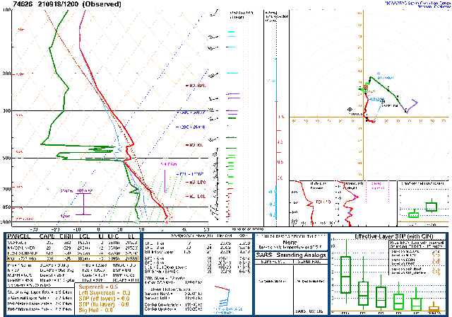
Moisture has gradually increased for much of the state over the past day or two. Tucson is up to around 40mm this morning, as well as a considerable MLCAPE of 1300 J/kg. The vertical wind profile is also moderately favorable to steer higher elevation storms into the Tucson area. There is a significant subsidence inversion at 500mb, but it shouldn't be a problem with the amount of CAPE available. DCAPE is moderately high at 1300 J/kg, so storms will likely produce strong outflow boundaries, assisting in propagation.

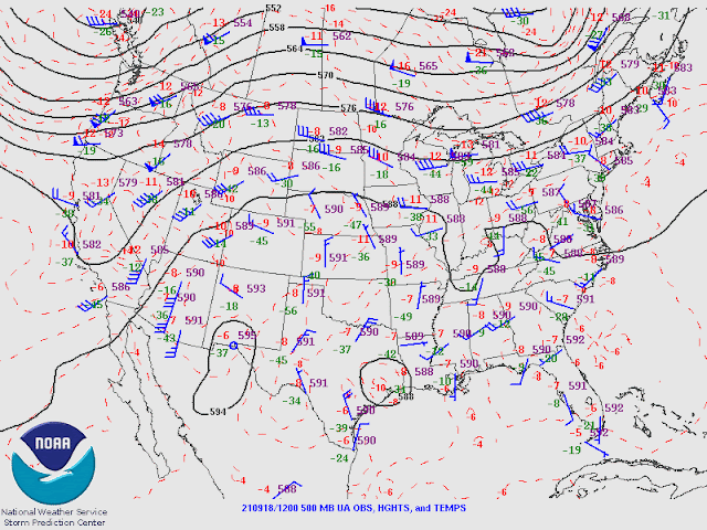
The 500mb map shows the anticyclone is centered over California, generally north to northeasterly flow over the state. The inversion is obvious with warm air at around -3 to -5C. Cooler air is upstream, though. There is a weak IT located over the far northern Chihuahua/Big Bend area, which is responsible for the ongoing showers and storms over far southern NM. This feature is likely to enhance thunderstorm activity in southern Arizona later today/tonight. Another IT/MCV is located over far northern Sinaloa and is responsible for the ongoing activity there.
Initializations
Remarkably, all initializations did well with both the clouds and ongoing showers/storms over southern NM. Most did well initializing the cyclonic circulations except for the 12Z HRRR, which had the IT a bit too far to the east. The HRRR and 12Z RR also didn't have enough clouds over far southeastern Arizona. Yes, you read that right; I've replaced the 12Z NAM with the HRRR and used the 0Z GFS for lateral boundary conditions to extend the run to 84 hours. From the first few runs, the WRFHRRR is usually quite similar to the HRRR, at least for the first 6-12 hours. After that, they start to diverge. Model accuracy is expected to be good, with the favored runs being the GFS and RR.
Day 1
Most, if not all, model runs over the past day, or two have been quite consistent in increasing storm activity for southeastern Arizona today. A surge is underway but is shallow and weak. The 850mb shows the wet/dry boundary quite well, with most of southeastern Arizona having dew points at or above 10C. Very dry air is still in place from about Phoenix and westward.
CAPE is low to moderate throughout much of SE Arizona. CAPE is minimal west of El Paso due to the ongoing activity there this morning.
Scattered storms develop during the early afternoon hours, mainly over the higher terrain of SW NM and southeastern Arizona. This may be a little too fast as the runs cleared out too quickly.
It looks good for the Tucson area as CAPE is from 900 to 1400 J/kg, the PBL is mixed deeply, and the vertical wind profile is excellent. There is low-level shear, mid-level northeastern 10-15 knot steering flow, and NW winds aloft keep anvils from advancing ahead of storms.
The Chihuahua IT moves a bit to the west, bringing cooler air at 500mb and NE steering flow over much of the state.
Later in the afternoon, storms move off of the higher terrain into the Tucson area, while other storms move off of the higher terrain of SW NM into eastern Cochise county.
Generally, outflow winds aren't too strong, at around 30-35 knots. A few locations could see stronger winds due to microbursts.
The runs have been quite consistent over the past 36 hours, and the most recent four runs continue that way. Some runs have precipitation amounts exceeding 2" for a few locations.
Storm intensity decreases into the evening. Storms cannot propagate down I-10 even with a favorable OFB due to the lack of CAPE.
Day 2
PW decreases over southern Arizona, resulting in mostly low CAPE, but maybe enough for a few storms.
At Tucson, it's not looking good for storms for multiple reasons. The first is the old rule that the next day after a big day is usually down. The other issues are a strengthening of the 500mb inversion and very dry air aloft. The wind profile is mainly unidirectional.
Little or no activity is forecast.


